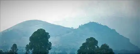
Mount Hehu
Mount Hehu (French: Mont Hehu) are large hills in the Buhumba Groupement in Bukumu Chefferie (chiefdom) in the Nyiragongo Territory of the North Kivu Province, Democratic Republic of the Congo. Mount Hehu is 2,430 meters high and situated nearby Hibumba and Bungeshi Mukuru villages on the border of Rwanda and the Democratic Republic of Congo.[1][2] The hills were occupied by Kumu (Bakumu or Komo) people, Bantu horticulturalists living in the autonomous villages collectively situated at the summit of a hill surrounded by a palisade in the tropical rainforests of Nyiragongo territory and Ituri Province in the eastern part of the Democratic Republic of the Congo.[3][4][5]

Mount Hehu lies between Kibumba and the border with Rwanda, and is exposed to alliances, militias, rebels and ever-evolving conflict sites across the region.[6][7] As a result of insurgent attacks, starvation, homelessness, unemployment, and horrific trauma, residents have fled their villages to Kanyaruchinya and Gasizi villages, rendering the hill and surrounding villages unoccupied.[8][9][10]
History
On October 25, 2013 the Forces Armées de la République Démocratique du Congo (FARDC) dislodged the March 23 Movement (M23) from Kibumba, located 27 kilometers north of the city of Goma, in North Kivu. Though, the rebels took up residence on the Hehu Hill, on the border with Rwanda, making little resistance.[11][12]
In January 2014 two young boys were killed in the Nyiragongo territory (North Kivu). According to local sources, the population accuses the FARDC of being responsible for the murder of two young boys. The perpetrator, whom they identify as a soldier, was probing for the victim's grandfather around Hehu's locality at approximately 9 pm (local time) to kill him. When he pulled the trigger the bullet struck his grandson, who died at the scene.[13]
On November 14, 2022 the resumption of fighting between the FARDC and the M23 around Kibumba resulted in the displacement of civilians in the Kibumba and Buhumba villages. The M23 seized control of the Mwaro village with the aim of controlling Gasizi and the strategic hill of Hehu.[14]
See also
References
- Congo (Léopoldville)-Rwanda Boundary. Indiana University, Bloomington, Indiana. 1965. pp. 4–5.
{{cite book}}: CS1 maint: location missing publisher (link) - "Pamphlets on Biology: Kofoid Collection, Volume 715". Google Books (in French and English). The University of California. 1903. Retrieved 2023-04-08.
- "Bukumu Royal Family, Nyirangongo Territory, Democratic Republic of Congo – THE AFRICAN ROYAL FAMILIES". theafricanroyalfamilies.com. 2022-09-02. Retrieved 2023-04-08.
- Project, Joshua. "Kumu in Congo, Democratic Republic of". joshuaproject.net. Retrieved 2023-04-08.
- "La justice chez les Bakumu, masse: s.d. | AfricaMuseum – Archives". archives.africamuseum.be. Retrieved 2023-04-08.
- "RD Congo : Les rebelles du M23 commettent des crimes de guerre". Human Rights Watch (in French). 2012-09-10. Retrieved 2023-04-08.
- "RDC: reprise des combats dans le Nord-Kivu". RFI (in French). 2012-11-17. Retrieved 2023-04-08.
- "Nord-Kivu : les FARDC contrôlent le centre de Kibumba après avoir repoussé le M23". Radio Okapi (in French). 2013-10-25. Retrieved 2023-04-08.
- "Nord-Kivu : 2 soldats tués dans les affrontements avec des FDLR au Mont Mikeno". Radio Okapi (in French). 2018-12-18. Retrieved 2023-04-08.
- "Nord-Kivu : 150 familles de Kibumba réfugiées à Kanyaruchinya pour fuir le M23". Radio Okapi (in French). 2013-10-19. Retrieved 2023-04-08.
- "Nord-Kivu : les FARDC contrôlent le centre de Kibumba après avoir repoussé le M23". Radio Okapi (in French). 2013-10-25. Retrieved 2023-04-08.
- "Nord-Kivu : les FARDC délogent le M23 de Kibumba". Radio Okapi (in French). 2013-10-26. Retrieved 2023-04-08.
- "Nord-Kivu : la population en colère après le meurtre de 2 jeunes à Nyiragongo". Radio Okapi (in French). 2014-01-13. Retrieved 2023-04-08.
- "Nord-Kivu : reprise des combats entre FARDC et M23 autour de Kibumba". Radio Okapi (in French). 2022-11-14. Retrieved 2023-04-08.