Mount Katamuki
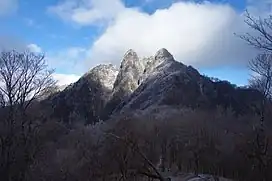
Mount Katamuki (傾山) (1,602 m (5,256 ft)) is at the western end of the Sobo Mountain range in Ōita Prefecture. It is now part of the Sobo, Katamuki and Okue Biosphere Reserve.[1][2]
| Mount Katamuki | |
|---|---|
 Mount Katamuki in winter | |
| Highest point | |
| Elevation | 1,602 m (5,256 ft) |
| Coordinates | 32°50′21″N 131°28′33″E |
| Naming | |
| Native name | 傾山 (Japanese) |
| English translation | “tilting”, and was given to this mountain because it tilts toward Mount Sobo |
| Geography | |
| Climbing | |
| Easiest route | from Kuori trailhead (all routes are not for inexperienced) |
Formation
It is believed that the foundation of the Sobo mountain range occurred in two periods of volcanic activity. The first, around 13 million years ago, was buried in the second period of volcanic activity ending about 10 million years ago leaving the landscape seen today. The extinct Katamukiyama Caldera is aligned on a NW to SE axis and was 11 km (6.8 mi) by 6 km (3.7 mi) in size with a DRE erupted volume of 50 km3 (12 cu mi).[3] From about 3 million years ago the activity of the Aso volcano caused nearby pyroclastic flow deposition.
Environment
The slopes of the mountain is covered by old-growth forest. Typical species include Japanese beech and hemlock. Going up from the lowland, the vegetation changes from evergreen (glossy-leaved) forest over conifer forest halfway up the mountain, to Suzu-take and beech close to the summit.
References
- "Sobo, Katamuki and Okue Biosphere Reserve, Japan". UNESCO. 25 October 2018. Retrieved 1 October 2022.
- "Sobo, Katamuki and Okue Biosphere Reserve". Retrieved 2022-10-01.
- Daisuke, Miura; Yutaka, Wada (2007). "Middle Miocene ash-flow calderas at the compressive margin of southwest Japan arc: Review and synthesis". The Journal of the Geological Society of Japan. 113 (7): 283–295. doi:10.5575/geosoc.113.283. Retrieved 8 August 2019.
