Mount Lovenia
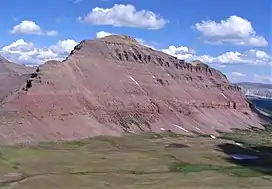
Mount Lovenia is a 13,219-foot elevation (4,029 m) mountain summit located on the common border that Duchesne County shares with Summit County in the U.S. state of Utah.
| Mount Lovenia | |
|---|---|
 West aspect | |
| Highest point | |
| Elevation | 13,219 ft (4,029 m)[1][2] |
| Prominence | 1,459 ft (445 m)[3] |
| Parent peak | Henrys Fork Peak (13,260 ft)[4] |
| Isolation | 11.59 mi (18.65 km)[4] |
| Coordinates | 40°45′24″N 110°36′26″W[5] |
| Geography | |
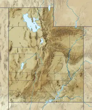 Mount Lovenia Location in Utah  Mount Lovenia Mount Lovenia (the United States) | |
| Location | High Uintas Wilderness |
| Country | United States of America |
| State | Utah |
| County | Duchesne / Summit |
| Parent range | Uinta Mountains Rocky Mountains |
| Topo map | USGS Mount Lovenia |
| Geology | |
| Age of rock | Neoproterozoic |
| Type of rock | Metasedimentary rock |
| Climbing | |
| Easiest route | class 2 scrambling[4] |
Description
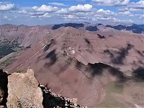
Mount Lovenia is set within the High Uintas Wilderness on land managed by Ashley National Forest. It is situated along the crest of the Uinta Mountains which are a subset of the Rocky Mountains, and it ranks as the 10th-highest summit in Utah, and 51st-highest in the United States if a 400-foot clean prominence cutoff is considered as criteria.[3] Topographic relief is significant as the west face rises 2,000 feet (610 meters) in less than one-half mile and the north face rises 1,800 feet (550 meters) in one-half mile. Neighbors include Wasatch Peak two miles to the north-northwest, and Dead Horse Peak is five miles to the west-southwest. Precipitation runoff from this mountain drains north to the Blacks Fork and south into headwaters of the Lake Fork River.
Etymology
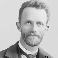
The landform's toponym has been officially adopted by the U.S. Board on Geographic Names.[5] Nature-lover and artist George Beard (1854–1944) of Coalville, Utah, named this mountain for his wife, Sarah Lovenia Bullock Beard (1859–1932), who was the daughter of Mormon pioneer Thomas Bullock.[6]
Climate
Based on the Köppen climate classification, Mount Lovenia is located in a subarctic climate zone with cold snowy winters and mild summers.[7] Tundra climate characterizes the summit and highest slopes.
See also
References
- United States Geological Survey topographical map - Mount Lovenia
- Adam Helman (2005), The Finest Peaks - Prominence and Other Mountain Measures, Trafford Publishing, ISBN 9781412059954
- "Mount Lovenia, Utah". Peakbagger.com. Retrieved 2022-08-05.
- "Lovenia, Mount - 13,219' UT". listsofjohn.com. Retrieved 2022-08-05.
- "Mount Lovenia". Geographic Names Information System. United States Geological Survey, United States Department of the Interior. Retrieved 2022-08-05.
- John W. Van Cott (1990), Utah Place Names, University of Utah Press, ISBN 9780874803457, p. 262
- Peel, M. C.; Finlayson, B. L. & McMahon, T. A. (2007). "Updated world map of the Köppen−Geiger climate classification". Hydrol. Earth Syst. Sci. 11 (5): 1633–1644. Bibcode:2007HESS...11.1633P. doi:10.5194/hess-11-1633-2007. ISSN 1027-5606. S2CID 9654551.
External links
- Mount Lovenia: weather forecast
- Mount Lovenia: Mountain-forecast.com
- Sarah Lovenia Bullock Beard (photo): Findagrave.com
- Photo of George and Lovenia Beard