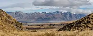
Two Thumb Range
The Two Thumb Range (sometimes called the Two Thumbs Range) is a range of mountains in the Canterbury Region of New Zealand's South Island. It is located to the east of Lake Tekapo and has several peaks which rise to around 2,500 metres (8,200 ft).[1] The southern end of the range contains one of Canterbury's main skifields, Mount Dobson.

.jpg.webp)
Geography
An eastern spur of the Southern Alps, the Two Thumb Range runs in a predominantly north-south direction for approximately 45 kilometres (28 mi). It and the smaller, mostly parallel, Sibbald Range branch from the Southern Alps close to Mount D'Archaic, 40 kilometres (25 mi) northeast of Aoraki / Mount Cook. The two ranges are separated by the valley of the Macauley River and form a barrier between the valleys of the Godley River and Lake Tekapo to the west and the Rangitata River to the east. The Two Thumb Range's peaks diminish in size towards its southern end, immediately to the east of the town of Lake Tekapo, after which it splits into two less significant ranges, the Rollesby and Albury ranges. At the saddle between the Two Thumb Range and these ranges, State Highway 8 crosses Burkes Pass on its route between Lake Tekapo and Fairlie.[2]
The South Opuha, Havelock, and Coal Rivers have their sources within the Two Thumb Range, as do numerous smaller watercourses, the most notable of which is Forest Creek, a tributary of the Rangitata River.
Peaks
Major peaks within the range include (from north to south):[1]
- Mount D'Archaic — 2,875 metres (9,432 ft)
- Mount Alma — 2,510 metres (8,230 ft)
- Mount Achilles — 2,540 metres (8,330 ft)
- Mount Myrmidon — 2,474 metres (8,117 ft)
- The Thumbs — 2,546 metres (8,353 ft)
- Captains Peak — 2,371 metres (7,779 ft)
- Mount Hope — 2,086 metres (6,844 ft)
- Mount Misery — 2,305 metres (7,562 ft)
- Dobson Peak — 2,095 metres (6,873 ft)
The names of several of the range's peaks, including Mount Achilles and Mount Graf Spee, commemorate New Zealand's involvement in the Battle of the River Plate.
Recreation
Dobson Peak and its surrounding terrain are the home of the Mount Dobson skifield.[3] The smaller Roundhill Ski Area is also located within the range.
New Zealand's major north-to-south walking track, Te Araroa Trail, crosses the Rangitata River before following the valley of a tributary, Bush Stream, into the Two Thumb Range. It crosses the range at Stag Saddle — the trail's highest point at 1,925 metres (6,316 ft) — immediately to the north of Mount Hope, before following the eastern shore of Lake Tekapo south.[4]
In popular culture
The Two Thumb Range was the setting for Desmond Bagley's 1975 novel, The Snow Tiger.
References
- Two Thumb Range, Canterbury, NZTopoMap. Retrieved 22 January 2022.
- Dowling, P. (ed.) (2004). ’’Reed New Zealand atlas’’. Auckland: Reed Publishing. ISBN 0 7900 0952 8
- "Mt Dobson Ski Area," Tekapo Tourism. Retrieved 22 January 2022.
- "Two Thumb Track," Te Araroa - New Zealand's Trail, updated 20 January 2022. Retrieved 22 January 2022.