Mount Murchison (Tasmania)
Mount Murchison is a mountain on the West Coast Range, located in the West Coast region of Tasmania, Australia.
| Mount Murchison | |
|---|---|
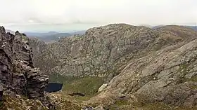
 A view over Shaded Lake near the peak of Mount Murchison | |
| Highest point | |
| Elevation | 1,275 m (4,183 ft)[1] |
| Prominence | 760 m (2,490 ft)[1] |
| Isolation | 19.96 km (12.40 mi)[1] |
| Coordinates | 41°48′00″S 145°36′36″E |
| Geography | |
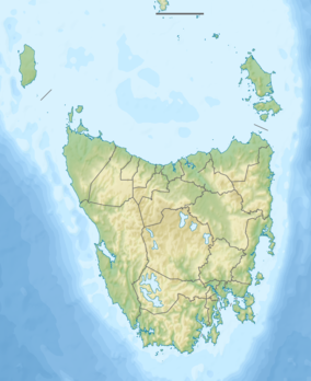
 Mount Murchison Location in Tasmania | |
| Location | Western Tasmania, Australia |
| Parent range | West Coast Range |
| Geology | |
| Age of rock | Jurassic |

At 1,275 metres (4,183 ft) above sea level, it is the highest mountain in the range and within the top thirty highest mountains in Tasmania.[1]
Location and features
Lying close to the Williamsford and Tullah mining areas, the mountain is often found referred to in early photographs.[2] It is located in the Mount Murchison Regional Reserve[3] and lies east of Zeehan, and Mount Read,[4] and north of Mount Tyndall. The track to the summit takes approximately 2.5 hours to complete with infrequent rests. The total walk to time to the summit and return is approximately 5.5 to 6 hrs.
From the trig point the nearby Towns of Tullah, Rosebery and Zeehan can be seen on a clear day. Mount Murchison is for moderately experienced climbers and contains sections that includes loose and sometimes slippery rock.
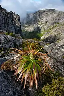
The first part of the track winds through dense bush and involves stepping over a lot of tree roots. The track breaks from the bush straight into a view of the surrounding area. Navigation from this point onwards involves moving between rock cairns and bits of tape to ensure you are on the track. At one point on the track about a third from the top requires an ascent up a 2-metre rise. As of June 2018, the rope attached to assist at that point is still in serviceable condition.
Water is available from about two thirds up the track from snow runoff which forms a little spring.
The last third of the track across the top to get to the trig point is quite narrow and has a fall off to the right. There is also a 1.5 metre ledge to climb up on to as part of the last section of the track.
The geology of the ground around the mountain relates to the range of mining activities nearby.[5]
On the south eastern side there a number of lakes, some unnamed. From the north, they are Shaded Lake, Little Sister, Lake Gaye and Lake Sandra lying to the east of the southernmost part of the main mountain, and below a very steep cliff.
According to local tradition, it is considered good luck to throw a sausage off the top of the mountain to ward off animals on the descent.[6]
It was named by Charles Gould in the early 1860s.[7]
References
- "Mount Murchison, Australia". Peakbagger.com. Retrieved 7 June 2015.
- "PICTURESQUE TASMANIA: MOUNT MURCHISON, LOOKING EAST FROM WILLIAMSFORD-ROAD". The Australasian (Melbourne, Vic. : 1864 - 1946). Melbourne, Vic.: National Library of Australia. 18 February 1905. p. 27. Retrieved 23 February 2015.
- "National Parks and Reserves under the Nature Conservation Act 2002 managed by the Tasmania Parks and Wildlife Service" (PDF). Tasmania Parks and Wildlife Service. 2 June 2022. p. 22. Retrieved 9 August 2022.
- "OPENING UP NEW COUNTRY". Zeehan and Dundas Herald (Tas. : 1890 - 1922). Tas.: National Library of Australia. 23 May 1912. p. 2. Retrieved 9 June 2015.
- McNiell, A W; Corbett, Keith D; Tasmania. Division of Mines and Mineral Resources; Mt. Read Volcanics Project (1992), Geology and mineralisation of the Mt Murchison area (MRVP map 4), Department of Mines & Mineral Resources, ISBN 978-0-7246-2147-7
- "Tassie Tales Blog". Tassie Tales Blog. 21 February 2017. Retrieved 10 July 2017.
- Baillie, Peter (2010). "The West Coast Range, Tasmania: Mountains and Geological Giants" (PDF). Papers and Proceedings of the Royal Society of Tasmania (reprint ed.). Hobart, Tasmania: University of Tasmania. 144: 1–13. ISSN 0080-4703. Archived from the original (PDF) on 16 June 2015. Retrieved 18 June 2015.
Bibliography
- Banks, M. R.; Kirkpatrick, J. B., eds. (1977). Landscape and Man, the interaction between man and environment in Western Tasmania. Royal Society of Tasmania. ISBN 978-0959867923.
- Binks, C.J. (1980). Explorers of Western Tasmania. Launceston: Mary Fisher Bookshop. ISBN 0-908291-16-7.
- Blainey, Geoffrey (2000). The Peaks of Lyell (6th ed.). Hobart: St. David's Park Publishing. ISBN 0-7246-2265-9.
- Whitham, Charles (2003). Western Tasmania - A land of riches and beauty (Reprint 2003 ed.). Queenstown: Municipality of Queenstown.
- Whitham, Lindsay (2002). Railways, Mines, Pubs and People and other historical research. Sandy Bay: Tasmanian Historical Research Association. ISBN 0-909479-21-6.