Mount Pleasant, Tennessee
Mount Pleasant is a city in Maury County, Tennessee, United States. Mount Pleasant was the birthplace of 19th-century writer and humorist Samuel R. Watkins and formerly titled "The Phosphate Capital of the World." The population was 4,561 at the 2010 census, and 4,784 in 2020.
Mount Pleasant, Tennessee | |
|---|---|
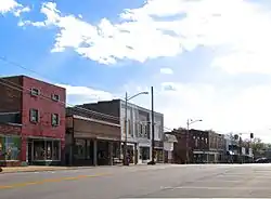 Mount Pleasant Main Street, October 2016 | |
 Seal | |
| Nickname: The Phosphate Capital of the World | |
 Location of Mount Pleasant in Maury County, Tennessee. | |
| Coordinates: 35°32′42″N 87°11′55″W | |
| Country | United States |
| State | Tennessee |
| County | Maury |
| Government | |
| • Type | City Manager-Commission |
| • City Manager | Kate Collier |
| • Mayor | Bill White |
| Area | |
| • Total | 12.60 sq mi (32.64 km2) |
| • Land | 12.58 sq mi (32.57 km2) |
| • Water | 0.03 sq mi (0.07 km2) |
| Elevation | 676 ft (206 m) |
| Population | |
| • Total | 4,784 |
| • Density | 380.38/sq mi (146.87/km2) |
| Time zone | UTC-6 (Central (CST)) |
| • Summer (DST) | UTC-5 (CDT) |
| ZIP code | 38474 |
| Area code | 931 |
| FIPS code | 47-51080[3] |
| GNIS feature ID | 1306783[4] |
| Website | www |

History
Settlement of Mount Pleasant began in the early 19th century, and increased following the construction of the Military Road connecting Nashville and Madisonville, Louisiana, in 1817. By the time Mount Pleasant incorporated as a city in 1824, it was home to a store, tavern, and several churches.[5]
In 1895, brown phosphate rock was discovered in Mount Pleasant, leading to a mining boom, and giving the city its nickname. Within a few years, ten phosphate mining companies were operating in Mount Pleasant, producing over 25,000 tons per year. The city's population grew from 466 in 1890 to 2,007 in 1900. Phosphate mining remained a major part of the city's economy into the latter half of the 20th century.[5]
Geography
Mount Pleasant is located at 35°32′42″N 87°11′55″W (35.544977, -87.198683).[6] According to the United States Census Bureau, the city has a total area of 11.1 square miles (29 km2), of which 11.1 square miles (29 km2) is land and 0.04 square miles (0.10 km2) (0.18%) is water. Mount Pleasant is situated in a relatively broad plain surrounded by low hills to the east, south, and west. U.S. Route 43 connects the city with Columbia to the northeast and Lawrenceburg to the south.
Climate
| Climate data for Mount Pleasant 1N, Tennessee (1991–2020 normals, extremes 1953–present) | |||||||||||||
|---|---|---|---|---|---|---|---|---|---|---|---|---|---|
| Month | Jan | Feb | Mar | Apr | May | Jun | Jul | Aug | Sep | Oct | Nov | Dec | Year |
| Record high °F (°C) | 76 (24) |
84 (29) |
87 (31) |
93 (34) |
99 (37) |
107 (42) |
105 (41) |
106 (41) |
105 (41) |
97 (36) |
85 (29) |
76 (24) |
107 (42) |
| Average high °F (°C) | 47.3 (8.5) |
52.3 (11.3) |
61.3 (16.3) |
71.6 (22.0) |
79.9 (26.6) |
87.6 (30.9) |
90.5 (32.5) |
89.6 (32.0) |
83.7 (28.7) |
72.5 (22.5) |
61.2 (16.2) |
50.9 (10.5) |
70.7 (21.5) |
| Daily mean °F (°C) | 37.2 (2.9) |
41.8 (5.4) |
49.8 (9.9) |
59.5 (15.3) |
69.1 (20.6) |
77.2 (25.1) |
79.9 (26.6) |
78.0 (25.6) |
71.4 (21.9) |
59.5 (15.3) |
48.7 (9.3) |
40.6 (4.8) |
59.4 (15.2) |
| Average low °F (°C) | 27.1 (−2.7) |
31.3 (−0.4) |
38.4 (3.6) |
47.4 (8.6) |
58.4 (14.7) |
66.7 (19.3) |
69.2 (20.7) |
66.4 (19.1) |
59.2 (15.1) |
46.6 (8.1) |
36.3 (2.4) |
30.3 (−0.9) |
48.1 (8.9) |
| Record low °F (°C) | −17 (−27) |
−8 (−22) |
5 (−15) |
20 (−7) |
31 (−1) |
38 (3) |
47 (8) |
44 (7) |
33 (1) |
23 (−5) |
9 (−13) |
−10 (−23) |
−17 (−27) |
| Average precipitation inches (mm) | 5.25 (133) |
5.14 (131) |
6.00 (152) |
5.42 (138) |
6.27 (159) |
5.40 (137) |
4.78 (121) |
3.96 (101) |
5.34 (136) |
3.89 (99) |
4.26 (108) |
6.52 (166) |
62.23 (1,581) |
| Average precipitation days (≥ 0.01 in) | 10.0 | 10.1 | 10.9 | 9.2 | 10.6 | 9.5 | 9.6 | 8.5 | 7.0 | 8.3 | 9.2 | 10.0 | 112.9 |
| Source: NOAA[7][8] | |||||||||||||
Demographics
| Census | Pop. | Note | %± |
|---|---|---|---|
| 1890 | 466 | — | |
| 1900 | 2,007 | 330.7% | |
| 1910 | 1,973 | −1.7% | |
| 1920 | 2,093 | 6.1% | |
| 1930 | 2,010 | −4.0% | |
| 1940 | 3,089 | 53.7% | |
| 1950 | 2,931 | −5.1% | |
| 1960 | 2,921 | −0.3% | |
| 1970 | 3,530 | 20.8% | |
| 1980 | 3,375 | −4.4% | |
| 1990 | 4,278 | 26.8% | |
| 2000 | 4,491 | 5.0% | |
| 2010 | 4,561 | 1.6% | |
| 2020 | 4,784 | 4.9% | |
| Sources:[9][10][2] | |||
2020 census
| Race | Number | Percentage |
|---|---|---|
| White (non-Hispanic) | 3,440 | 71.91% |
| Black or African American (non-Hispanic) | 894 | 18.69% |
| Native American | 15 | 0.31% |
| Asian | 31 | 0.65% |
| Pacific Islander | 2 | 0.04% |
| Other/Mixed | 267 | 5.58% |
| Hispanic or Latino | 135 | 2.82% |
As of the 2020 United States census, there were 4,784 people, 1,935 households, and 1,318 families residing in the city.
2000 census
As of the census[3] of 2000, there were 4,491 people, 1,815 households, and 1,232 families residing in the city. The population density was 406.5 inhabitants per square mile (157.0/km2). There were 2,008 housing units at an average density of 181.8 per square mile (70.2/km2). The racial makeup of the city was 75.02% White, 23.45% African American, 0.33% Native American, 0.11% Asian, 0.02% Pacific Islander, 0.24% from other races, and 0.82% from two or more races. Hispanic or Latino of any race were 0.87% of the population.
There were 1,815 households, out of which 33.3% had children under the age of 18 living with them, 44.6% were married couples living together, 19.2% had a female householder with no husband present, and 32.1% were non-families. 28.7% of all households were made up of individuals, and 13.7% had someone living alone who was 65 years of age or older. The average household size was 2.43 and the average family size was 2.97.
In the city, the population was spread out, with 26.4% under the age of 18, 8.0% from 18 to 24, 28.2% from 25 to 44, 22.0% from 45 to 64, and 15.4% who were 65 years of age or older. The median age was 37 years. For every 100 females, there were 82.8 males. For every 100 females age 18 and over, there were 75.2 males.
The median income for a household in the city was $32,004, and the median income for a family was $36,949. Males had a median income of $31,285 versus $22,599 for females. The per capita income for the city was $16,345. About 14.9% of families and 18.5% of the population were below the poverty line, including 27.6% of those under age 18 and 14.1% of those age 65 or over.
Government
The City of Mount Pleasant government consists of five elected commissioners, elected every four years. After each election, at the next scheduled commission meeting, the five commissioners vote on which commissioners will server as mayor and vice mayor. In case of tie or disagreement, the commission will continue nominating and voting until a majority vote is achieved for each position.
Current Mount Pleasant, Tennessee Commissioners
- Bill White (Mayor)
- Jacqueline Grandberry (Vice Mayor)
- Willie Alderson[12]
- Mike Davis
- Eric Harvey[12]
The City Manager is selected, by the commission, and is hired on a variable year contract. The city managers is responsible for day to day operations of the city. Additionally, the city manager is the supervisor of all other city departments heads and staff.
| City Manager | Notes | Start Date | End Date |
|---|---|---|---|
| William C. Dunnebacke | 02-19-1963 | 02-10-1964 | |
| Elizabeth Searson | (interim) | 02-08-1964 | 04-01-1964 |
| W.C. Loden | 04-01-1964 | 07-01-1966 | |
| Elizabeth Searson | (interim) | 05-24-1966 | 06-30-1966 |
| Jay N. Sullivan | 07-01-1966 | 10-14-1968 | |
| Elizabeth Searson | (interim) | 10-15-1968 | 03-01-1969 |
| O.W. Thomas | 03-02-1969 | 07-14-1975 | |
| Mike Brown | 07-15-1975 | 09-11-1976 | |
| William Burgess Ralston | (interim) | 09-11-1976 | 10-04-1976 |
| Carl Holder | 10-04-1976 | 10-17-1978 | |
| Larry Holden | (interim) | 11-12-1978 | 01-08-1979 |
| James R. Johnson | 01-08-1979 | 09-01-1981 | |
| Larry Holden | (interim) | 09-11-1981 | 10-01-1981 |
| Robert Murray | 10-16-1981 | 06-30-2007 | |
| Debbie McMullin | (interim) | 07-01-2007 | 05-01-2008 |
| Richard Goode | 05-01-2008 | 06-30-2009 | |
| Debbie McMullin | (interim) | 06-30-2009 | 06-18-2010 |
| Steve Huffer | 06-18-2010 | 08-11-2011 | |
| Tommy G. Goetz | (interim) | 08-11-2011 | 01-01-2012 |
| Michelle Williams | 01-01-2012 | 07-21-2015 | |
| Mark Henderson | (interim) | 07-22-2015 | 11-03-2015 |
| Michael Hay | (interim) | 11-03-2015 | 02-05-2016 |
| Kate Collier | 02-05-2016 | Present |
| Mayor | Start Date | End Date |
|---|---|---|
| Dr. G. C. English | 07-11-1940 | 07-11-1957 |
| John W. Petty | 07-23-1957 | 07-08-1963 |
| Webb Williams | 07-22-1963 | 06-20-1967 |
| Dr. J. O. Williams, Jr | 07-18-1967 | 06-30-1970 |
| Jack Lightfoot | 07-19-1970 | 07-15-1975 |
| James L. (Jim) Bailey, Jr. | 07-15-1975 | 07-19-1977 |
| Ronald (Ronnie) Lankford | 07-19-1977 | 01-26-1979 |
| William H. Boyd | 02-16-1979 | 07-19-1983 |
| G. Ray Wilson | 07-19-1983 | 12-31-1985 |
| Willie B. Baker [13][14][15] | 12-31-1985 | 07-18-1989 |
| Willie Boyd [16] | 07-18-1989 | 03-30-2006 |
| Willie B. Baker | 03-30-2006 | 07-17-2007 |
| Richard A. Hendrix | 07-17-2007 | 07-19-2011 |
| Maury Colvett | 08-11-2011 | 11-18-2014 |
| Robert R. (Bob) Shackelford | 11-18-2014 | 11-22-2016 |
| James L. (Jim) Bailey, Jr.[17] | 11-22-2016 | 12-18-2018 |
| Bill White | 12-18-2018 | Present |
Police Department
The Mount Pleasant Police Department was established in 1824.
- 2014–Present — Michael Hay[18]
Fire Department
The Mount Pleasant Fire Department is a career fire department consisting of full-time and part time firefighters. The fire department was established in 1899.
- 1988—2001 - M. H. "Cotton" Massey
- 2001—2017 - Tim Smith
- 2017—Present - Phillip Grooms[19]
Transportation
Mount Pleasant is located on U.S. Route 43, as well as State Routes 243 and 166.
Mount Pleasant is also home to the Maury County Regional Airport.
Public transportation is provided by the Mule Town Trolley Service. The Mule Town Trolley connects people all across Maury County. The routes extend from Mount Pleasant to Columbia and on to Spring Hill. The fare is $1.00 each way and riders can request a stop anywhere along the trolley route. The trolley service is managed by the South Central Tennessee Development District.
See also
References
- "ArcGIS REST Services Directory". United States Census Bureau. Retrieved October 15, 2022.
- "Census Population API". United States Census Bureau. Retrieved October 15, 2022.
- "U.S. Census website". United States Census Bureau. Retrieved January 31, 2008.
- "US Board on Geographic Names". United States Geological Survey. October 25, 2007. Retrieved January 31, 2008.
- Elizabeth Straw, Historic and Architectural Resources of Mount Pleasant, Tennessee, National Register of Historic Places inventory form, January 1989.
- "US Gazetteer files: 2010, 2000, and 1990". United States Census Bureau. February 12, 2011. Retrieved April 23, 2011.
- "NowData - NOAA Online Weather Data". National Oceanic and Atmospheric Administration. Retrieved October 2, 2021.
- "Station: MT Pleasant 1N, TN". U.S. Climate Normals 2020: U.S. Monthly Climate Normals (1991-2020). National Oceanic and Atmospheric Administration. Retrieved October 2, 2021.
- "Census of Population and Housing: Decennial Censuses". United States Census Bureau. Retrieved March 4, 2012.
- "Incorporated Places and Minor Civil Divisions Datasets: Subcounty Resident Population Estimates: April 1, 2010 to July 1, 2012". Population Estimates. U.S. Census Bureau. Archived from the original on June 11, 2013. Retrieved December 11, 2013.
- "Explore Census Data". data.census.gov. Retrieved December 26, 2021.
- "Mt. Pleasant reelects two board members and welcomes two newcomers".
- "Willie B. Baker". Columbia Daily Herald. September 20, 2012.
- DuBois (2007–2008). "A RESOLUTION to recognize Mount Pleasant Mayor Willie Baker on the occasion of his retirement. HOUSE JOINT RESOLUTION 667" (PDF). Tennessee State Legislature.
- "Directory of Tennessee Municipal Officials 1988-89, page 128". University of Tennessee, Knoxville. 1989.
- "Former mayor honored with sign". Columbia Daily Herald. April 24, 2014.
- CHRISTEN, MIKE. "Bailey accepts job as mayor of Mt. Pleasant". The Daily Herald. Retrieved August 16, 2017.
- "City names new police chief". The Daily Herald. Retrieved August 16, 2017.
- CHRISTEN, MIKE. "Grooms named Mt. Pleasant fire chief". The Daily Herald. Retrieved August 16, 2017.
External links
- Official website
- Municipal Technical Advisory Service entry for Mount Pleasant — information on local government, elections, and link to charter
Municipalities and communities of Maury County, Tennessee, United States | ||
|---|---|---|
| Cities | Maury County map | |
| Unincorporated communities | ||
| Footnotes | ‡This populated place also has portions in an adjacent county or counties | |