Mount Wellington, New Zealand
Mount Wellington (Māori: Maungarei)[3] is a suburb in East Auckland, New Zealand, located 10 kilometres southeast of the city centre. It is surrounded by the suburbs of Stonefields, Tamaki, Panmure, Penrose, and Ellerslie, and by the Tamaki River. The suburb is named after the volcanic peak of Maungarei / Mount Wellington. Sylvia Park is a large business park and shopping centre located in the suburb.
Mount Wellington | |
|---|---|
 | |
| Coordinates: 36.908°S 174.839°E | |
| Country | New Zealand |
| City | Auckland |
| Local authority | Auckland Council |
| Electoral ward | Maungakiekie-Tāmaki ward |
| Local board | Maungakiekie-Tāmaki Local Board |
| Area | |
| • Land | 1,036 ha (2,560 acres) |
| Population (June 2023)[2] | |
| • Total | 25,070 |
| Train station(s) | Sylvia Park Railway Station |
| Ellerslie, St. John's Park, Panmure | ||
| Penrose |
|
Tamaki River, Pakuranga, Panmure |
| Westfield | Panmure |
Geography and early history
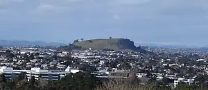
Maungarei / Mount Wellington is a 135-metre[4] volcanic peak of the Auckland volcanic field. It is the youngest onshore volcano of the Auckland volcanic field, having been formed by an eruption around 10,000 years ago. It is the largest of Auckland's scoria cones.[5] Prior to European settlement, the area around Maungarei was bracken scrub and not densely forested.[6] The southern section, closer to Ōtāhuhu / Mount Richmond, was primarily broadleaf and podocarp forest with patches of clear scrubland.[7]
The isthmus south of the mountain was traditionally settled by Ngāi Tāhuhu, descendants of Tāhuhunui-o-te-rangi, captain of the Moekākara waka and namesake of Ōtāhuhu.[8][9] Four archaeological sites near Carbine Road/Panama Road near the Tamaki River were occupied in the mid to late 1500s.[9] A large number of storage pits for root vegetables (such as kūmara) were found at the sites, suggesting the area was extensively gardened by Māori, as well as an area where toki (adze) were created.[7][9] South of Mutukaroa / Hamlins Hill was Karetu, a 2 km portage between the Waitematā Harbour/Tāmaki River and the Manukau Harbour.[9]
Demographics
Mount Wellington covers 10.36 km2 (4.00 sq mi)[1] and had an estimated population of 25,070 as of June 2023,[2] with a population density of 2,420 people per km2.
While most of the suburb is residential, Sylvia Park is almost entirely commercial, and the central area of Mount Wellington Industrial is almost entirely industrial.
| Year | Pop. | ±% p.a. |
|---|---|---|
| 2006 | 21,162 | — |
| 2013 | 23,292 | +1.38% |
| 2018 | 25,236 | +1.62% |
| Source: [10] | ||
Mount Wellington had a population of 25,236 at the 2018 New Zealand census, an increase of 1,944 people (8.3%) since the 2013 census, and an increase of 4,074 people (19.3%) since the 2006 census. There were 7,914 households, comprising 12,573 males and 12,663 females, giving a sex ratio of 0.99 males per female, with 4,716 people (18.7%) aged under 15 years, 6,249 (24.8%) aged 15 to 29, 11,409 (45.2%) aged 30 to 64, and 2,862 (11.3%) aged 65 or older.
Ethnicities were 38.8% European/Pākehā, 11.7% Māori, 21.6% Pacific peoples, 37.5% Asian, and 3.0% other ethnicities. People may identify with more than one ethnicity.
The percentage of people born overseas was 47.5, compared with 27.1% nationally.
Although some people chose not to answer the census's question about religious affiliation, 33.1% had no religion, 43.6% were Christian, 0.9% had Māori religious beliefs, 7.6% were Hindu, 2.7% were Muslim, 3.9% were Buddhist and 3.1% had other religions.
Of those at least 15 years old, 5,919 (28.8%) people had a bachelor's or higher degree, and 2,790 (13.6%) people had no formal qualifications. 3,129 people (15.2%) earned over $70,000 compared to 17.2% nationally. The employment status of those at least 15 was that 11,436 (55.7%) people were employed full-time, 2,304 (11.2%) were part-time, and 873 (4.3%) were unemployed.[10]
| Name | Area (km2) | Population | Density (per km2) | Households | Median age | Median income |
|---|---|---|---|---|---|---|
| Mount Wellington North West | 0.92 | 3,129 | 3,401 | 1,278 | 39.9 years | $36,300[11] |
| Mount Wellington North East | 0.73 | 2,067 | 2,832 | 726 | 34.1 years | $41,300[12] |
| Mount Wellington Ferndale | 0.86 | 4,158 | 4,835 | 1,356 | 32.1 years | $38,000[13] |
| Mount Wellington East | 0.60 | 2,676 | 4,460 | 795 | 31.5 years | $33,600[14] |
| Mount Wellington West | 0.78 | 2,985 | 3,827 | 885 | 31.9 years | $38,400[15] |
| Mount Wellington Central | 1.21 | 4,827 | 3,989 | 1,425 | 33.9 years | $34,700[16] |
| Sylvia Park | 0.56 | 132 | 236 | 39 | 31.1 years | $35,400[17] |
| Mount Wellington Industrial | 3.33 | 18 | 5 | — | 40.0 years | $27,900[18] |
| Mount Wellington South West | 0.67 | 2,391 | 3,569 | 690 | 30.6 years | $33,700[19] |
| Mount Wellington South East | 0.70 | 2,853 | 4,076 | 720 | 29.3 years | $26,000[20] |
| New Zealand | 37.4 years | $31,800 |
Economy
Retail
The Sylvia Park shopping centre opened in 2006,[21] and an upgrade opened in 2020.[22] The mall has 106,427 m2 of lettable space spread across two floors,[21] alongside 4,053 carparks.[23] Its 250 stores include anchor tenants The Warehouse, Farmers, Kmart, Pak'nSave and a 10-screen Hoyts Cinema.[24]
Mt Wellington Shopping Centre has 22 stores spread across 9,000 m2, including anchor tenants Countdown and Supercheap Auto.[25]
Education
Bailey Road School, Stanhope Road School and Sylvia Park School are state full primary schools (years 1–8) with rolls of 373, 529 and 517 students, respectively.[26][27][28]
Panama Road School is a contributing primary school (years 1–6) with a roll of 272 students.[29]
All these school are coeducational. Rolls are as of April 2023.[30]
References
- "ArcGIS Web Application". statsnz.maps.arcgis.com. Retrieved 21 July 2022.
- "Population estimate tables - NZ.Stat". Statistics New Zealand. Retrieved 25 October 2023.
- "Maungarei - te Aka Māori Dictionary".
- "Mt Wellington—Maunga-a-Reipae". Archived from the original on 11 February 2009. Retrieved 5 March 2009.
- "Volcanoes of Auckland: Mt Wellington". Auckland Regional Council. Archived from the original on 11 February 2009. Retrieved 5 March 2009.
- Leahy, Anne (1991). "EXCAVATIONS AT TAYLOR'S HILL, R11/96, AUCKLAND". Records of the Auckland Institute and Museum. 28: 33–68. ISSN 0067-0464.
- Foster, Russell; Sewell, Brenda (1989). "THE EXCAVATION OF SITES R11/887, R11/888 AND R11/899, TAMAKI, AUCKLAND". Records of the Auckland Institute and Museum. 26: 1–24. ISSN 0067-0464.
- Taonui, Professor Rawiri (2017). "THE WHANGAREI COAST Te Whanga-o-Reitū or Te Whanga-o-Reipae" (PDF). LINKNZ. Immigration New Zealand, Ministry of Business, Innovation and Employment (68): 4–12. ISSN 2324-3848. Retrieved 17 February 2021.
- Furey, Louise (1986). "THE EXCAVATION OF WESTFIELD (R11/898), SOUTH AUCKLAND". Records of the Auckland Institute and Museum. 23: 1–24. ISSN 0067-0464.
- "Statistical area 1 dataset for 2018 Census". Statistics New Zealand. March 2020. Mount Wellington North West (145300), Mount Wellington North East (146000), Mount Wellington Ferndale (146200), Mount Wellington East (146500), Mount Wellington West (146600), Mount Wellington Central (147200), Sylvia Park (147400), Mount Wellington Industrial (147700), Mount Wellington South West (149100) and Mount Wellington South East (149500).
- 2018 Census place summary: Mount Wellington North West
- 2018 Census place summary: Mount Wellington North East
- 2018 Census place summary: Mount Wellington Ferndale
- 2018 Census place summary: Mount Wellington East
- 2018 Census place summary: Mount Wellington West
- 2018 Census place summary: Mount Wellington Central
- 2018 Census place summary: Sylvia Park
- 2018 Census place summary: Mount Wellington Industrial
- 2018 Census place summary: Mount Wellington South West
- 2018 Census place summary: Mount Wellington South East
- Nadkarni, Anjua (15 October 2020). "Sylvia Park opens new $277 million shopping floor with new stores". stuff.co.nz.
- Nadkarni, Anuja (15 October 2020). "Sylvia Park opens new $277 million shopping floor with new stores". stuff.co.nz.
- "Sylvia Park". kiwiproperty.com. Kiwi Property Group.
- "Sylvia Park Stores". kiwiproperty.com. Kiwi Property Group.
- "Special Meeting of Shareholders 2020" (PDF). investoreproperty.co.nz. Investore Property. 16 January 2020.
- Education Counts: Bailey Road School
- Education Counts: Stanhope Road School
- Education Counts: Sylvia Park School
- Education Counts: Panama Road School
- "New Zealand Schools Directory". New Zealand Ministry of Education. Retrieved 12 December 2022.
- Volcanoes of Auckland: The Essential guide - Hayward, B.W., Murdoch, G., Maitland, G.; Auckland University Press, 2011.
External links
- Bailey Road School
- Stanhope school
- Sylvia Park School
- Photographs of Mount Wellington held in Auckland Libraries' heritage collections.