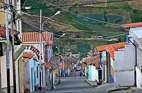
Mucuchíes
Mucuchíes is a town in the Rangel Municipality of Mérida State, Venezuela. It is at an altitude of 2,983 meters and has a cool climate, with an average temperature of 11 °C. The town was founded by Bartolomé Gil Naranjo in 1586.[1]
Mucuchíes | |
|---|---|
 | |
.svg.png.webp) Mucuchíes | |
| Coordinates: 8°45′00″N 70°55′00″W | |
| Country | Venezuela |
| States | Mérida |
| Municipalities | Rangel Municipality |
| Demonym | Mucuchicero |
| Elevation | 2,983 m (9,787 ft) |
| Population (2011) | |
| • Total | 6,354 |
| Time zone | UTC-4:30 |
| Postal Code | 5130 |
| Area code | +58 274 |
| Climate | Cfb |
Festivals
Patron saint festivities are held during the month of December, with their patron saints St. Lucia and St. Benedict the Moor.

Geography
Climate
Köppen-Geiger climate classification system classifies its climate as subtropical highland (Cfb),[2] while bordering on páramo climate (ET). This is primarily influenced by its surrounding altitudes, which maintain average temperatures consistently below 10°C throughout the year. This combination of factors creates a distinctive climatic environment that blends subtropical characteristics with the colder conditions typically associated with alpine regions.
| Climate data for Mucuchíes, Mérida, Venezuela | |||||||||||||
|---|---|---|---|---|---|---|---|---|---|---|---|---|---|
| Month | Jan | Feb | Mar | Apr | May | Jun | Jul | Aug | Sep | Oct | Nov | Dec | Year |
| Average high °C (°F) | 18 (64) |
18.5 (65.3) |
18.1 (64.6) |
17.5 (63.5) |
17.3 (63.1) |
16.7 (62.1) |
16.6 (61.9) |
17.1 (62.8) |
17.4 (63.3) |
17.2 (63.0) |
17.3 (63.1) |
18 (64) |
17.5 (63.4) |
| Daily mean °C (°F) | 10.7 (51.3) |
11.4 (52.5) |
11.6 (52.9) |
11.8 (53.2) |
12.1 (53.8) |
11.9 (53.4) |
11.6 (52.9) |
11.8 (53.2) |
11.9 (53.4) |
11.8 (53.2) |
11.4 (52.5) |
11.1 (52.0) |
11.6 (52.9) |
| Average low °C (°F) | 3.5 (38.3) |
4.3 (39.7) |
5.2 (41.4) |
6.2 (43.2) |
7 (45) |
7.1 (44.8) |
6.6 (43.9) |
6.5 (43.7) |
6.4 (43.5) |
6.4 (43.5) |
5.5 (41.9) |
4.3 (39.7) |
5.7 (42.4) |
| Average precipitation mm (inches) | 14 (0.6) |
13 (0.5) |
24 (0.9) |
103 (4.1) |
117 (4.6) |
98 (3.9) |
89 (3.5) |
92 (3.6) |
88 (3.5) |
103 (4.1) |
64 (2.5) |
18 (0.7) |
823 (32.5) |
| Average rainy days | 6 | 6 | 9 | 17 | 18 | 18 | 18 | 20 | 19 | 18 | 13 | 10 | 172 |
| Mean daily sunshine hours | 8 | 7 | 6 | 5 | 4 | 4 | 5 | 5 | 5 | 5 | 5 | 7 | 6 |
| Source 1: Climate-Data.org (altitude: 2899m)[2] | |||||||||||||
| Source 2: Weather2Travel (rainy days, sun)[3] | |||||||||||||
References
- "La población de Mucuchíes". CIBERTRONIC C.A. Retrieved 2009-11-19.
- "Temperature, Climate graph, Climate table for Mucuchies". Climate-Data.org. Retrieved 2017-10-07.
- "Merida Climate: Monthly Weather Averages, Venezuela". Weather2Travel. Retrieved 2017-10-07.