Muljan
Muljan (Bengali: মুলজান) is a village under Manikganj Sadar Upazila of Manikganj District, Bangladesh.
Muljan
মুলজান | |
|---|---|
Rural | |
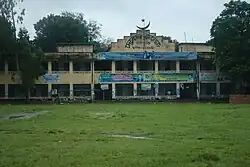 Skyline of Muljan, Manikganj Sadar, Bangladesh | |
 Muljan Location in Bangladesh | |
| Coordinates: 23°52.3′N 89°58′E | |
| Country | |
| Division | Dhaka |
| Upazila | Manikganj Sadar |
| Area | |
| • Total | 1.73 km2 (0.67 sq mi) |
| Population (2011) | |
| • Total | 1,394 |
| • Density | 810/km2 (2,100/sq mi) |
| Time zone | UTC+6 (BST) |
Geography
Muljan is located at 23.8721°N 89.9659°E. It has a total area of 427 acres (1.73 km2).[1]
Demographics
According to the 2011 Bangladesh census, Muljan had 350+ households and a population of 1,394.[1]
Administration
Muljan has 1 rural, The Rural are - korcha Badha. 3 Mauzas/Mahallas, and 1 villages.
Infrastructure
Dighi Union has many institute. Among te institution-
- Dighi Union Muljan
- Grameen Bank Muljan
- Union Health Center
- Manikganj Palli Bidyut Samity
- Muljan Bus Station
- Muljan Jame Mosque
Roads
National Highway 5 Dhaka-Bangladesh Highway. N5 (Bangladesh)
Education
Among the educational institutions.
Higher secondary educational institutions
No.
Secondary educational institution
Muljan High School
References
- "Population Census 2011: Manikganj Table C-01" (PDF). Bangladesh Bureau of Statistics. Archived from the original (PDF) on November 13, 2014. Retrieved July 11, 2014.
This article is issued from Wikipedia. The text is licensed under Creative Commons - Attribution - Sharealike. Additional terms may apply for the media files.