Shire of Mundaring
The Shire of Mundaring is a local government area in eastern metropolitan Perth, the capital of Western Australia. The Shire covers an area of 645 square kilometres (249 sq mi) and had a population of approximately 38,000 as at the 2016 Census.
| Shire of Mundaring Western Australia | |||||||||||||||
|---|---|---|---|---|---|---|---|---|---|---|---|---|---|---|---|
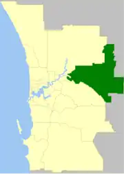 The Shire of Mundaring within the Perth Metropolitan Area | |||||||||||||||
| Population | 39,166 (LGA 2021)[1] | ||||||||||||||
| Established | 1903 | ||||||||||||||
| Area | 644.9 km2 (249.0 sq mi) | ||||||||||||||
| Shire President | James Martin | ||||||||||||||
| Council seat | Mundaring | ||||||||||||||
| Region | Eastern Metropolitan Perth Darling Scarp | ||||||||||||||
| State electorate(s) | Darling Range, Kalamunda, Midland, Swan Hills | ||||||||||||||
| Federal division(s) | Hasluck, Pearce | ||||||||||||||
| Website | Shire of Mundaring | ||||||||||||||
| |||||||||||||||
History
The Greenmount Road District was created on 17 April 1903. On 29 March 1934, it was renamed the Mundaring Road District. On 1 July 1961, it became the Shire of Mundaring following the passage of the Local Government Act 1960, which reformed all remaining road districts into shires.[2]
Statistics
Mundaring Shire has published the following statistics for the period 1994-2006:[3]
- Population: 35,097
- Area: 643.32 km2
- Rateable area: 205.91 km2
- Rateable properties: 15,251
- Revenue: A$50.1M
- Vested reserves: 104.60 km2
- Forests and National Parks: 238.30 km2
Wards
The shire is divided into four wards.
National Parks
The Shire contains three national parks and numerous nature reserves:
Trails
The Shire is recognised for its natural environment and has numerous walk and ride trails:
- Bibbulmun Track
- C Y O'Connor Trail
- Eagle View Walk Trail
- Forsyths Mill Mountain Bike Track
- Kep Track
- Lake Leschenaultia Trails
- Munda Biddi Trail
- Railway Reserves Heritage Trail
- Weir View Walk
Suburbs and localities
The suburbs and localities of the Shire of Mundaring with population and size figures based on the most recent Australian census:[8][9]
| Suburb | Population | Area | Map |
|---|---|---|---|
| Bailup | 54 (SAL 2021)[10] | 47 km2 (18 sq mi) | |
| Beechina | 128 (SAL 2021)[11] | 6.8 km2 (2.6 sq mi) | |
| Bellevue | 1,514 (SAL 2021)[12] | 3 km2 (1.2 sq mi) | |
| Boya | 669 (SAL 2021)[13] | 1.9 km2 (0.73 sq mi) | |
| Chidlow | 1,821 (SAL 2021)[14] | 44.8 km2 (17.3 sq mi) | |
| Darlington | 3,725 (SAL 2021)[15] | 12.2 km2 (4.7 sq mi) | |
| Glen Forrest | 2,789 (SAL 2021)[16] | 13.2 km2 (5.1 sq mi) | |
| Greenmount | 2,666 (SAL 2021)[17] | 4.8 km2 (1.9 sq mi) | |
| Gorrie | 0 (SAL 2016)[18][19] | 26.3 km2 (10.2 sq mi) | |
| Helena Valley | 4,130 (SAL 2021)[20] | 6.3 km2 (2.4 sq mi) | |
| Hovea | 713 (SAL 2021)[21] | 31.6 km2 (12.2 sq mi) | |
| Mahogany Creek | 829 (SAL 2021)[22] | 6.1 km2 (2.4 sq mi) | |
| Midvale | 2,283 (SAL 2021)[23] | 2.9 km2 (1.1 sq mi) | |
| Mount Helena | 3,373 (SAL 2021)[24] | 28.7 km2 (11.1 sq mi) | |
| Mundaring | 3,190 (SAL 2021)[25] | 31.7 km2 (12.2 sq mi) | |
| Parkerville | 2,432 (SAL 2021)[26] | 19 km2 (7.3 sq mi) | |
| Sawyers Valley | 1,001 (SAL 2021)[27] | 170.2 km2 (65.7 sq mi) | |
| Stoneville | 2,489 (SAL 2021)[28] | 18.2 km2 (7.0 sq mi) | |
| Swan View | 7,889 (SAL 2021)[29] | 7.5 km2 (2.9 sq mi) | |
| The Lakes | 20 (SAL 2021)[30] | 31 km2 (12 sq mi) | |
| Wooroloo | 2,613 (SAL 2021)[31] | 47.5 km2 (18.3 sq mi) |
Population
|
|
Presidents and chairmen
Heritage-listed places
As of 2023, 143 places are heritage-listed in the Shire of Mundaring,[32] of which 26 are on the State Register of Heritage Places, among them John Forrest National Park, Lake Leschenaultia and the Swan View Tunnel.[33]
References
- Australian Bureau of Statistics (28 June 2022). "Mundaring (Local Government Area)". Australian Census 2021 QuickStats. Retrieved 28 June 2022.
- "Municipality Boundary Amendments Register" (PDF). Western Australian Electoral Distribution Commission. Retrieved 11 January 2020.
- Mundaring Shire Council. "Population & Area". Archived from the original on 19 February 2006. Retrieved 1 April 2006.
- https://www.mundaring.wa.gov.au/AboutCouncil/Council/Pages/ElectedMembers.aspx West Ward (three councillors)]
- South Ward (three councillors)
- Central Ward (three councillors)
- East Ward (three councillors)
- "SLIP Map". maps.slip.wa.gov.au. Landgate. Retrieved 1 January 2023.
- "NationalMap". nationalmap.gov.au. Geoscience Australia. Retrieved 1 January 2023.
- Australian Bureau of Statistics (28 June 2022). "Bailup (Suburb and Locality)". Australian Census 2021 QuickStats. Retrieved 28 June 2022.
- Australian Bureau of Statistics (28 June 2022). "Beechina (Suburb and Locality)". Australian Census 2021 QuickStats. Retrieved 28 June 2022.
- Australian Bureau of Statistics (28 June 2022). "Bellevue (WA) (Suburb and Locality)". Australian Census 2021 QuickStats. Retrieved 28 June 2022.
- Australian Bureau of Statistics (28 June 2022). "Boya (Suburb and Locality)". Australian Census 2021 QuickStats. Retrieved 28 June 2022.
- Australian Bureau of Statistics (28 June 2022). "Chidlow (Suburb and Locality)". Australian Census 2021 QuickStats. Retrieved 28 June 2022.
- Australian Bureau of Statistics (28 June 2022). "Darlington (WA) (Suburb and Locality)". Australian Census 2021 QuickStats. Retrieved 28 June 2022.
- Australian Bureau of Statistics (28 June 2022). "Glen Forrest (Suburb and Locality)". Australian Census 2021 QuickStats. Retrieved 28 June 2022.
- Australian Bureau of Statistics (28 June 2022). "Greenmount (WA) (Suburb and Locality)". Australian Census 2021 QuickStats. Retrieved 28 June 2022.
- Australian Bureau of Statistics (27 June 2017). "Gorrie (Suburb and Locality)". Australian Census 2016.
- Australian Bureau of Statistics (27 June 2017). "Gorrie (Suburb and Locality)". Australian Census 2016 QuickStats. Retrieved 28 June 2022.
- Australian Bureau of Statistics (28 June 2022). "Helena Valley (Suburb and Locality)". Australian Census 2021 QuickStats. Retrieved 28 June 2022.
- Australian Bureau of Statistics (28 June 2022). "Hovea (Suburb and Locality)". Australian Census 2021 QuickStats. Retrieved 28 June 2022.
- Australian Bureau of Statistics (28 June 2022). "Mahogany Creek (Suburb and Locality)". Australian Census 2021 QuickStats. Retrieved 28 June 2022.
- Australian Bureau of Statistics (28 June 2022). "Midvale (Suburb and Locality)". Australian Census 2021 QuickStats. Retrieved 28 June 2022.
- Australian Bureau of Statistics (28 June 2022). "Mount Helena (Suburb and Locality)". Australian Census 2021 QuickStats. Retrieved 28 June 2022.
- Australian Bureau of Statistics (28 June 2022). "Mundaring (Suburb and Locality)". Australian Census 2021 QuickStats. Retrieved 28 June 2022.
- Australian Bureau of Statistics (28 June 2022). "Parkerville (Suburb and Locality)". Australian Census 2021 QuickStats. Retrieved 28 June 2022.
- Australian Bureau of Statistics (28 June 2022). "Sawyers Valley (Suburb and Locality)". Australian Census 2021 QuickStats. Retrieved 28 June 2022.
- Australian Bureau of Statistics (28 June 2022). "Stoneville (Suburb and Locality)". Australian Census 2021 QuickStats. Retrieved 28 June 2022.
- Australian Bureau of Statistics (28 June 2022). "Swan View (Suburb and Locality)". Australian Census 2021 QuickStats. Retrieved 28 June 2022.
- Australian Bureau of Statistics (28 June 2022). "The Lakes (Suburb and Locality)". Australian Census 2021 QuickStats. Retrieved 28 June 2022.
- Australian Bureau of Statistics (28 June 2022). "Wooroloo (Suburb and Locality)". Australian Census 2021 QuickStats. Retrieved 28 June 2022.
- "Shire of Mundaring Heritage Places". inherit.stateheritage.wa.gov.au. Heritage Council of Western Australia. Retrieved 16 February 2023.
- "Shire of Mundaring State Register of Heritage Places". inherit.stateheritage.wa.gov.au. Heritage Council of Western Australia. Retrieved 16 February 2023.