Mungar
Mungar is a rural locality in the Fraser Coast Region, Queensland, Australia.[2] In the 2016 census, Mungar had a population of 309 people.[1]
| Mungar Queensland | |||||||||||||||
|---|---|---|---|---|---|---|---|---|---|---|---|---|---|---|---|
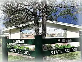 Mungar State School, 2023 | |||||||||||||||
 Mungar | |||||||||||||||
| Coordinates | 25.6027°S 152.5944°E | ||||||||||||||
| Population | 309 (2016 census)[1] | ||||||||||||||
| • Density | 20.33/km2 (52.65/sq mi) | ||||||||||||||
| Postcode(s) | 4650 | ||||||||||||||
| Area | 15.2 km2 (5.9 sq mi) | ||||||||||||||
| Time zone | AEST (UTC+10:00) | ||||||||||||||
| Location |
| ||||||||||||||
| LGA(s) | Fraser Coast Region | ||||||||||||||
| State electorate(s) | Maryborough | ||||||||||||||
| Federal division(s) | Wide Bay | ||||||||||||||
| |||||||||||||||
Geography
Mungar is 247 kilometres (153 mi) north of the state capital Brisbane and 20 kilometres (12 mi) south west of the regional centre of Maryborough.
The Mungar Junction to Monto Branch Railway branches from the North Coast railway line at Mungar.
History
Mary River Saw Mill Provisional School opened on 9 July 1875. On 24 Sep 1877, it was renamed Mungar State School.[3]
At the 2011 census, Mungar and the surrounding area had a population of 264.[4]
Education
Mungar State School is a government primary (Prep-6) school for boys and girls at 1143 Mungar Road (25.6041°S 152.5906°E).[5][6] In 2017, the school had an enrolment of 44 students with 3 teachers (2 full-time equivalent) and 4 non-teaching staff (3 full-time equivalent).[7]
There are no secondary schools in Mungar. The nearest government secondary school is Aldridge State High School in Maryborough to the north-east.[8]
See also
References
- Australian Bureau of Statistics (27 June 2017). "Mungar (SSC)". 2016 Census QuickStats. Retrieved 20 October 2018.
- "Mungar – locality in Fraser Coast Region (entry 46730)". Queensland Place Names. Queensland Government. Retrieved 16 November 2019.
- Queensland Family History Society (2010), Queensland schools past and present (Version 1.01 ed.), Queensland Family History Society, ISBN 978-1-921171-26-0
- Australian Bureau of Statistics (31 October 2012). "Mungar (State Suburb)". 2011 Census QuickStats. Retrieved 13 June 2015.
- "State and non-state school details". Queensland Government. 9 July 2018. Archived from the original on 21 November 2018. Retrieved 21 November 2018.
- "Mungar State School". Mungar State School. 28 July 2022. Archived from the original on 1 March 2023. Retrieved 13 September 2023.
- "ACARA School Profile 2017". Archived from the original on 22 November 2018. Retrieved 22 November 2018.
- "Layers: Locality; Schools and school catchments". Queensland Globe. Queensland Government. Archived from the original on 19 December 2017. Retrieved 13 September 2023.