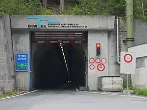
Munt la Schera Tunnel
The Munt la Schera Tunnel is a single lane road tunnel located in the Swiss canton of Graubünden. It connects the Engadin valley with Lago di Livigno, through Munt la Schera. Completed in 1965, the tunnel is 3,394 metres (11,135 ft) in length.[1]
 | |
| Overview | |
|---|---|
| Location | Graubünden, Switzerland |
| Coordinates | 46°38′6″N 10°11′55″E |
| Operation | |
| Opened | 1965 (for private use) 1968 (for public use) |
| Character | road, one-way |
| Technical | |
| Length | 3,394 metres (11,135 ft) |
| No. of lanes | 1 |
| Highest elevation | 1,809 metres (5,935 ft) |
| Lowest elevation | 1,711 metres (5,614 ft) |
The tunnel was built to transport building materials for the construction of the Punt dal Gall dam. It was opened for public use in 1968, but is still owned and operated by the hydroelectric power company Engadiner Kraftwerke AG. The tunnel is only wide enough for a single vehicle so traffic moves in alternate directions, controlled by traffic lights which change every 15 minutes. (A different pattern of alternating traffic applies on Saturdays in winter.[2][3]) The tunnel is open 24 hours a day to motor vehicles no more than 3.6 metres (12 ft) in height and 2.5 metres (8 ft 2 in) in width but since 2008 it is closed to cyclists.[2] From June to September, cyclists may take their cycles on a half-hourly shuttle bus, and at other times they may use a limited number of places on the public bus service.
As of May 2015, the standard daytime toll for a single car journey through the tunnel is CHF16/EUR15. Slightly higher tolls are charged at night.[4]
References
- "Munt la Schera Tunnel (Grisons, 1965)". structurae.net. Retrieved 2014-07-19.
- "Tunnel Livigno - Opening Times [in German]". Engadiner Kraftwerke AG. Retrieved 2015-07-13.
- "Tunnel Munt la Schera". Chalet Claudia. Retrieved 2014-07-19.
- "Tunnel Munt La Schera - Summer Price List - valid from May 1st 2015 [in German]" (PDF). Engadiner Kraftwerke AG. Retrieved 2015-07-13.