Muosuchan Range
The Muosuchan Range (Russian: Муосучанский Хребет;[2] Yakut: Муоһучаан сис) is a range of mountains in far North-eastern Russia. Administratively the range is part of the Sakha Republic, Russian Federation.
| Muosuchan Range | |
|---|---|
| Муосучанский Хребет / Муоһучаан сис | |
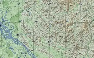 ONC chart section showing the SW section of the Verkhoyansk Range | |
| Highest point | |
| Peak | Unnamed |
| Elevation | 1,243 m (4,078 ft) |
| Coordinates | 64°45′N 127°30′E[1] |
| Dimensions | |
| Length | 120 km (75 mi) NW / SE |
| Width | 30 km (19 mi) NE/ SW |
| Geography | |
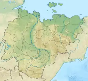 Muosuchan Range Location in the Sakha Republic, Russia | |
| Location | Sakha Republic, Far Eastern Federal District |
| Parent range | Verkhoyansk Range, East Siberian System |
| Geology | |
| Orogeny | Alpine orogeny |
| Type of rock | Shale, sandstone, limestone |
Geography
The Muosuchan Range is one of the subranges of the Verkhoyansk Range system and is located in its southwestern section.[3] It stretches roughly from northwest to southeast between the Bygyn Range to the west and the Tagindzhin Range to the east, running in a roughly parallel direction to both ranges. The southeastern end is bound by the valleys of the Munni (a tributary of the (Belyanka) and the Buruolakh (a tributary of the (Lyapiske), beyond which the Munni Range stretches eastwards.[4][5]
River Lyapiske cuts across the range in its northwestern section and the Dyanyshka flows beyond the northern end. The highest point of the Muosuchan range is an unnamed 1,243 metres (4,078 ft) high peak. Lake Billyakh is located at the northwestern end of the range. Beyond it rises the Tekir Khaya (highest point 926 metres (3,038 ft)), a smaller range flanking the Dyanyshka river further to the northwest.[3][6][4][7]
References
- URSS 1,000,000 scale Operational Navigation Chart; Sheet C-6
- Аркадий Андреев, Горы Якутии (Arkady Andreyev, Mountains of Yakutia) p. 20
- Verkhoyansk Range / Great Soviet Encyclopedia; in 35 vols. / Ch. ed. Yu. S. Osipov. 2004—2017.
- Google Earth
- "Q-51_52 Chart (in Russian)". Retrieved 28 August 2021.
- Geological map of the Russian Federation In Russian)
- Late Quaternary Lake Dynamics in the Verkhoyansk Mountains of Eastern Siberia: Implications for Climate and Glaciation History