Murgash
Murgash is a peak in Bulgaria, in the Balkan Mountains mountain range. The peak is located in the East part of Murgash massive, with an altitude of 1,687 m (5,535 ft) above sea level.
| Murgash | |
|---|---|
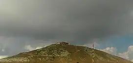 View toward Murgash peak | |
| Highest point | |
| Elevation | 1,687 m (5,535 ft) |
| Coordinates | 42°49′59″N 23°40′06″E |
| Geography | |
 Murgash peak Murgash peak's location on the map of Bulgaria | |
| Country | Bulgaria |
| Region | Sofia Province |
| Parent range | Balkan Mountains |
The peak consists of Paleozoic sediment and has a dome-shaped structure with steep slopes. Out of the summit of the peak stream two rivers – Baltuiska reka and Eleshnica river. The peak is an object of both international and national tourism. The Murgash touristic hut is located southwest of the peak with an altitude of 1490 meters.[1]
The Eleshnishki monastery is located near the west foot of the Murgash peak.[2]
In 1953, on Murgash peak a meteorological station was built and is still active.
Views from the peak
East
East from Murgash peak lies a long horizon, which allows tourists to enjoy a pleasant sunrise.
South East
From the peak, when looking toward South East, the Rhodope Mountain range can be seen.
West
To the West, when the weather is clear you can see Serbian land and mountains.[3]
Climate
Murgash has a humid continental climate (Köppen climate classification) bordering on subarctic climate (Köppen Dfc).
| Climate data for Murgash Peak, 1991-2020 (elevation 1687m) | |||||||||||||
|---|---|---|---|---|---|---|---|---|---|---|---|---|---|
| Month | Jan | Feb | Mar | Apr | May | Jun | Jul | Aug | Sep | Oct | Nov | Dec | Year |
| Record high °C (°F) | 13.6 (56.5) |
12.8 (55.0) |
17.2 (63.0) |
20.4 (68.7) |
24.8 (76.6) |
25.1 (77.2) |
31.0 (87.8) |
29.5 (85.1) |
25.2 (77.4) |
24.1 (75.4) |
20.5 (68.9) |
14.5 (58.1) |
31.0 (87.8) |
| Average high °C (°F) | −1.9 (28.6) |
−1.6 (29.1) |
1.3 (34.3) |
6.3 (43.3) |
11.3 (52.3) |
14.9 (58.8) |
17.2 (63.0) |
17.8 (64.0) |
13.2 (55.8) |
8.9 (48.0) |
4.1 (39.4) |
−0.5 (31.1) |
7.6 (45.6) |
| Daily mean °C (°F) | −4.6 (23.7) |
−4.3 (24.3) |
−1.6 (29.1) |
2.9 (37.2) |
7.8 (46.0) |
11.5 (52.7) |
13.6 (56.5) |
14.0 (57.2) |
9.6 (49.3) |
5.4 (41.7) |
1.3 (34.3) |
−3.1 (26.4) |
4.4 (39.9) |
| Average low °C (°F) | −7.0 (19.4) |
−6.9 (19.6) |
−4.3 (24.3) |
0.2 (32.4) |
5.0 (41.0) |
8.6 (47.5) |
10.5 (50.9) |
11.0 (51.8) |
6.9 (44.4) |
2.9 (37.2) |
−1.1 (30.0) |
−5.5 (22.1) |
1.7 (35.1) |
| Record low °C (°F) | −26.3 (−15.3) |
−25.1 (−13.2) |
−19.6 (−3.3) |
−13.5 (7.7) |
−4.9 (23.2) |
−1.5 (29.3) |
1.0 (33.8) |
0.2 (32.4) |
−3.8 (25.2) |
−11.3 (11.7) |
−17.6 (0.3) |
−23.2 (−9.8) |
−26.3 (−15.3) |
| Average precipitation mm (inches) | 39 (1.5) |
38 (1.5) |
46 (1.8) |
56 (2.2) |
110 (4.3) |
106 (4.2) |
88 (3.5) |
69 (2.7) |
65 (2.6) |
53 (2.1) |
34 (1.3) |
40 (1.6) |
744 (29.3) |
| Source: NOAA[4] | |||||||||||||
References
- "Vrah Murgash (Murgash Peak) (In Bulgarian Language)". Strannik.bg.
- "Murgash peak meteorological station (In Bulgarian Language)". Meteo.bg.
- "Връх Мургаш – Върхове в Странник.бг". strannik.bg. Retrieved 26 March 2021.
- "Murgash Peak Climate Normals 1991-2020". National Oceanic and Atmospheric Administration. Retrieved 29 August 2023.