Muri District
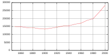
Muri District is a district in the Swiss Canton of Aargau with the administrative capital of Muri. It covers the central and southern part of Freiamt and has a population of 37,379 (as of 31 December 2020).[1]
Muri District
Bezirk Muri | |
|---|---|
District | |
| Country | |
| Canton | |
| Capital | Muri |
| Area | |
| • Total | 138.96 km2 (53.65 sq mi) |
| Population (2020) | |
| • Total | 37,379 |
| • Density | 270/km2 (700/sq mi) |
| Time zone | UTC+1 (CET) |
| • Summer (DST) | UTC+2 (CEST) |
| Municipalities | 19 |
Geography
The Muri district has an area, as of 2009, of 138.96 square kilometers (53.65 sq mi). Of this area, 95.6 km2 (36.9 sq mi) or 68.8% is used for agricultural purposes, while 26.76 km2 (10.33 sq mi) or 19.3% is forested. Of the rest of the land, 13.62 km2 (5.26 sq mi) or 9.8% is settled (buildings or roads).[2]
Coat of arms

The blazon of the district coat of arms is Gules a Wall in fess embattled Argent masoned Sable..[3]
Demographics
The Muri district has a population (as of December 2020) of 37,379.[1] As of June 2009, 13.2% of the population are foreign nationals.[4]
Economy
In 2000 there were 15,053 workers who lived in the district. Of these, 10,391 or about 69.0% of the residents worked outside the Muri district while 4,675 people commuted into the district for work. There were a total of 9,337 jobs (of at least 6 hours per week) in the district.[5]
Religion
From the 2000 census, 18,897 or 66.9% were Roman Catholic, while 4,960 or 17.6% belonged to the Swiss Reformed Church. Of the rest of the population, there were 18 individuals (or about 0.06% of the population) who belonged to the Christian Catholic faith.[2]
Education
Of the school age population (in the 2008/2009 school year), there are 2,724 students attending primary school, there are 935 students attending secondary school, there are 569 students attending tertiary or university level schooling, and there are 14 students who are seeking a job after school in the municipality.[2]
Municipalities

| Coat of arms | Municipality | Population (31 December 2020)[1] |
Area, km² |
|---|---|---|---|
| Abtwil | 954 | 4.14 | |
| Aristau | 1,512 | 8.64 | |
| Auw | 2,203 | 8.61 | |
| Beinwil | 1,183 | 11.29 | |
| Besenbüren | 632 | 2.38 | |
| Bettwil | 654 | 4.25 | |
| Boswil | 2,923 | 11.78 | |
| Bünzen | 1,128 | 5.77 | |
| Buttwil | 1,234 | 4.61 | |
| Dietwil | 1,355 | 5.49 | |
| Geltwil | 221 | 3.28 | |
| Kallern | 399 | 2.67 | |
| Merenschwand | 3,712 | 13.51 | |
| Mühlau | 1,218 | 5.52 | |
| Muri | 8,244 | 12.34 | |
| Oberrüti | 1,544 | 5.37 | |
| Rottenschwil | 911 | 4.49 | |
| Sins | 4,299 | 20.28 | |
| Waltenschwil | 3,053 | 4.54 | |
| Total | 37,379 | 138.96 | |
Mergers
The following changes to the district's municipalities have occurred since 2000:
- On 1 January 2012 the municipality of Benzenschwil merged into Merenschwand.[6]
References
- "Ständige und nichtständige Wohnbevölkerung nach institutionellen Gliederungen, Geburtsort und Staatsangehörigkeit". bfs.admin.ch (in German). Swiss Federal Statistical Office - STAT-TAB. 31 December 2020. Retrieved 21 September 2021.
- Statistical Department of Canton Aargau - Aargauer Zahlen 2009 (in German) accessed 20 January 2010
- Flags of the World.com accessed 18-May-2010
- Statistical Department of Canton Aargau -Bereich 01 -Bevölkerung (in German) accessed 20 January 2010
- Statistical Department of Canton Aargau-Bereich 11 Verkehr und Nachrichtenwesen (in German) accessed 21 January 2010
- Amtliches Gemeindeverzeichnis der Schweiz published by the Swiss Federal Statistical Office (in German) accessed 21 December 2011