Mynydd Llwydiarth
Mynydd Llwydiarth is a mountain in southern Snowdonia, Wales.[2] It is a long ridge running from a low summit to the south of Mynydd Dolgoed, running south-west to Mynydd Cymerau. Nant Llwydiarth rises on the south flank of the mountain, and on the west slope the Ratgoed slate quarry operated until 1946.[3]
| Mynydd Llwydiarth | |
|---|---|
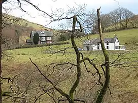
 Llwydiarth Hall on the southern slopes of Mynydd Llwydiarth | |
| Highest point | |
| Elevation | 467 m (1,532 ft)[1] |
| Naming | |
| Language of name | Welsh |
| Geography | |
| Location | Gwynedd, UK |
| Parent range | Snowdonia |
It is one of the Dyfi hills.
References
- Merionethshire XXXVIII.SW (Map). Ordnance Survey. Retrieved 9 September 2019.
- Cylchgrawn Cymdeithas Hanes a Chofnodion Sir Feirionydd. The Society. 1957.
- Richards, Alun John (1994). Slate Quarrying at Corris. Carreg Gwalch. ISBN 978-0-86381-279-8.
This article is issued from Wikipedia. The text is licensed under Creative Commons - Attribution - Sharealike. Additional terms may apply for the media files.