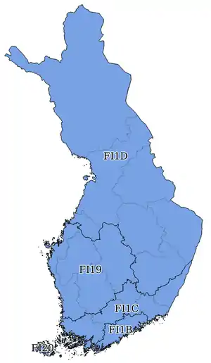
NUTS statistical regions of Finland
In the NUTS (Nomenclature of Territorial Units for Statistics) codes of Finland (FI), the three levels are:
| Level | Subdivisions | # |
|---|---|---|
| NUTS 1 | Mainland Finland, Åland (Finnish: Manner-Suomi, Ahvenanmaa; Swedish: Fasta Finland, Åland) | 2 |
| NUTS 2 | Large areas (Suuralueet / Storområden) | 5 |
| NUTS 3 | Regions (Maakunnat / Landskap) | 19 |
NUTS codes
2013 version.[1]
| NUTS 1 | Code | NUTS 2 | Code | NUTS 3 | Code |
|---|---|---|---|---|---|
| Mainland Finland | FI1 | West Finland | FI19 | Central Finland | FI193 |
 |
Southern Ostrobothnia | FI194 | |||
| Ostrobothnia | FI195 | ||||
| Satakunta | FI196 | ||||
| Pirkanmaa | FI197 | ||||
| Helsinki-Uusimaa | FI1B | Helsinki-Uusimaa | FI1B1 | ||
| South Finland | FI1C | Southwest Finland | FI1C1 | ||
| Kanta-Häme | FI1C2 | ||||
| Päijät-Häme | FI1C3 | ||||
| Kymenlaakso | FI1C4 | ||||
| South Karelia | FI1C5 | ||||
| North & East Finland | FI1D | Etelä-Savo | FI1D1 | ||
| Pohjois-Savo | FI1D2 | ||||
| North Karelia | FI1D3 | ||||
| Kainuu | FI1D4 | ||||
| Central Ostrobothnia | FI1D5 | ||||
| Northern Ostrobothnia | FI1D6 | ||||
| Lapland | FI1D7 | ||||
| Åland | FI2 | Åland | FI20 | Åland | FI200 |
In the 2003 version, Satakunta was coded FI191, and Pirkanmaa was coded FI192.
Local administrative units
Below the NUTS levels, the two LAU (Local Administrative Units) levels are:
| Level | Subdivisions | # |
|---|---|---|
| LAU 1 | Sub-regions (Seutukunnat / Ekonomiska regioner) | 77 |
| LAU 2 | Municipalities (Kunnat / Kommuner) | 416 |
See also
Sources
- Hierarchical list of the Nomenclature of territorial units for statistics - NUTS and the Statistical regions of Europe
- Overview map of EU Countries - NUTS level 1
- Correspondence between the NUTS levels and the national administrative units
- List of current NUTS codes
- Provinces of Finland, Statoids.com
References
This article is issued from Wikipedia. The text is licensed under Creative Commons - Attribution - Sharealike. Additional terms may apply for the media files.