Nabiganj Upazila
Nabiganj (Bengali: নবীগঞ্জ, romanized: Nobīgonj) is an Upazila of Habiganj District in the Division of Sylhet, Bangladesh.[1]
Nabiganj
নবীগঞ্জ | |
|---|---|
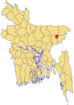 | |
| Coordinates: 24°34′N 91°30.9′E | |
| Division | Sylhet Division |
| District | Habiganj District |
| Thana | 1839 |
| Upazila | 1983 |
| Government | |
| • MP (Habiganj-1) | Gazi Mohammad Shahnawaz (Bangladesh Awami League) |
| • Upazila Chairman | Muhammad Fazlul Haq Chowdhury Salim Timirpuri |
| Area | |
| • Total | 439.6 km2 (169.7 sq mi) |
| Population | |
| • Total | 285,040 |
| • Density | 648/km2 (1,680/sq mi) |
| Demonym | Nabiganji or Nobigonji |
| Time zone | UTC+6 (BST) |
| Postal code | 3000 |
| Website | nabiganj |
History
After the Conquest of Sylhet in 1303, many disciples of Shah Jalal migrated and settled in present-day Nabiganj where they preached Islam to the local people. Shah Sikandar migrated to Paschimgaon (Sikandarpur), Hafiz Muhammad Zakariyyah Arabi to Pithua, Shah Sadruddin Qurayshi to Parbatpur (Sadrabad) and Qazi Tajuddin Qurayshi to Chouki.
In the late 17th century, Inathganj Bazar was founded. Inathganj became a centre for the Asian Jute trade. The current Inathganj High School was originally a jute warehouse. Many ships would crowd in the banks of Inathganj Bazar, and go to many corners of the world, and evidence of this remains at the present-day high school.[2]
Geography
Nabiganj is located at 24.56701°N 91.51430°E. It has 41358 households and total area 439.6 km2 (169.7 sq mi).
Demographics
As of the 1991 Bangladesh census, Nabiganj has a population of 246933. Males constitute 50.27% of the population, and females 49.73%. This Upazila's eighteen up population is 126527. Nabiganj has an average literacy rate of 26.4% (7+ years), and the national average of 32.4% literate.[3]
Administration
Nabiganj Upazila is divided into 13 union parishads: Aushkandi, Bausha, Debparra, Digholbak, Gaznaipur, Inatganj, Kaliarbhanga, Kargoan, Kurshi, Nabiganj Sadar, Paniumda, Paschim Bara Bhakoir, and Purba Bara Bhakoir. The union parishads are subdivided into 219 mauzas and 355 villages.[4]
People
- Abdul Moshabbir, lawyer
- Abdul Munim Chowdhury, former MP
- Abdul Momin Imambari, Bangladeshi Islamic scholar and politician
- Abdur Rouf Choudhury, writer
- Dewan Farid Gazi, politician
- Dewan Mahbubur Rob Sadi Chaudhuri (Bir Protik), Sub-Sector Commander (1971), Former MP[5]
- Foysol Choudhury, businessman and member of the Scottish Parliament
- Gazi Mohammad Shahnawaz, politician
- Ismat Ahmed Chowdhury, politician
- Khalilur Rahman Chowdhury, politician
- Shegufta Bakht Chaudhuri, fourth Governor of Bangladesh Bank
- Shah A M S Kibria, former Finance Minister of Bangladesh
- Anudvaipayan Bhattacharya, physicist
- Emamul Haque, deputy secretary, Bangladesh Parliament secretariat
References
- Kazi M Hasan Ali (2012). "Nabiganj Upazila". In Sirajul Islam; Miah, Sajahan; Khanam, Mahfuza; Ahmed, Sabbir (eds.). Banglapedia: the National Encyclopedia of Bangladesh (Online ed.). Dhaka, Bangladesh: Banglapedia Trust, Asiatic Society of Bangladesh. ISBN 984-32-0576-6. OCLC 52727562. OL 30677644M. Retrieved 25 October 2023.
- Fazlur Rahman (1991). Sileter Mati, Sileter Manush (in Bengali). Sylhet District: M A Sattar.
- "Population Census Wing, BBS". Archived from the original on 2005-03-27. Retrieved November 10, 2006.
- "District Statistics 2011: Habiganj" (PDF). Bangladesh Bureau of Statistics. Archived from the original (PDF) on 13 November 2014. Retrieved 14 July 2014.
- "List of 2nd Parliament Members" (PDF). Bangladesh Parliament (in Bengali). 13 August 2014.
Capital: Habiganj | ||
| Upazilas | ||
| Constituencies | ||
| Attractions and sites | ||
| Rivers | ||
| Educational institutions | ||
| History | ||
| Transport | ||
Capital: Sylhet | ||
| Habiganj District |  | |
| Moulvibazar District | ||
| Sunamganj District | ||
| Sylhet District | ||