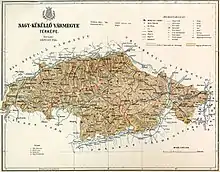
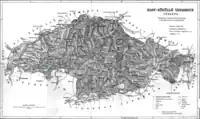
Nagy-Küküllő County
Nagy-Küküllő (Romanian: Comitatul Târnava-Mare) was an administrative county (comitatus) of the Kingdom of Hungary. Its territory is now in central Romania (central Transylvania). Nagy-Küküllő is the Hungarian name for the river Târnava Mare. The capital of the county was Segesvár (present-day Sighișoara).
| Nagy-Küküllő County | |
|---|---|
| County of the Kingdom of Hungary | |
| 1876–1920 | |
.svg.png.webp) Coat of arms
| |
 | |
| Capital | Segesvár |
| Area | |
| • Coordinates | 46°13′N 24°48′E |
• 1910 | 3,337 km2 (1,288 sq mi) |
| Population | |
• 1910 | 148800 |
| History | |
| History | |
• Established | 1876 |
| 4 June 1920 | |
| Today part of | Romania |
| Sighișoara is the current name of the capital. | |
Geography
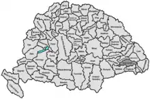
Nagy-Küküllő County shared borders with the Hungarian counties Alsó-Fehér, Kis-Küküllő, Udvarhely, Háromszék, Brassó, Fogaras, and Szeben. The river Târnava Mare formed part of its northern border and the river Olt part of its southern border. Its area was 3,337 km2 (1,288 sq mi) around 1910.
History
Nagy-Küküllő County came into existence in 1876, when the administrative structure of Transylvania was changed and Küküllő County was split. In 1920, by the Treaty of Trianon, the county became part of Romania. Its territory lies in the present Romanian counties Sibiu (the west), Brașov (the south-east), and Mureș (around Sighișoara).
Demographics
| Census | Total | German | Romanian | Hungarian | Other or unknown |
|---|---|---|---|---|---|
| 1880[1] | 132,454 | 57,398 (44.77%) | 51,632 (40.27%) | 12,026 (9.38%) | 7,155 (5.58%) |
| 1890[2] | 135,312 | 59,575 (44.03%) | 53,644 (39.64%) | 14,148 (10.46%) | 7,945 (5.87%) |
| 1900[3] | 145,138 | 61,769 (42.56%) | 61,779 (42.57%) | 17,139 (11.81%) | 4,451 (3.07%) |
| 1910[4] | 148,826 | 62,224 (41.81%) | 60,381 (40.57%) | 18,474 (12.41%) | 7,747 (5.21%) |
| Census | Total | Lutheran | Eastern Orthodox | Greek Catholic | Calvinist | Roman Catholic | Unitarian | Other or unknown |
|---|---|---|---|---|---|---|---|---|
| 1880 | 132,454 | 58,920 (44.48%) | 45,853 (34.62%) | 14,909 (11.26%) | 5,999 (4.53%) | 3,800 (2.87%) | 2,219 (1.68%) | 754 (0.57%) |
| 1890 | 135,312 | 59,501 (43.97%) | 46,209 (34.15%) | 15,582 (11.52%) | 6,796 (5.02%) | 3,856 (2.85%) | 2,546 (1.88%) | 822 (0.61%) |
| 1900 | 145,138 | 61,777 (42.56%) | 50,350 (34.69%) | 16,259 (11.20%) | 7,651 (5.27%) | 5,105 (3.52%) | 2,889 (1.99%) | 1,107 (0.76%) |
| 1910 | 148,826 | 62,370 (41.91%) | 51,705 (34.74%) | 17,062 (11.46%) | 8,320 (5.59%) | 5,042 (3.39%) | 3,222 (2.16%) | 1,105 (0.74%) |
Subdivisions
In the early 20th century, the subdivisions of Nagy-Küküllő County were:
| Districts (járás) | |
|---|---|
| District | Capital |
| Kőhalom | Kőhalom (now Rupea) |
| Medgyes | Medgyes (now Mediaș) |
| Nagysink | Nagysink (now Cincu) |
| Segesvár | Segesvár (now Sighișoara) |
| Szentágota | Szentágota (now Agnita) |
| Urban districts (rendezett tanácsú város) | |
| Medgyes (now Mediaș) | |
| Segesvár (now Sighișoara) | |
Notes
- Only linguistic communities > 1% are displayed.
- Only religious communities > 1% are displayed.
References
- "Az 1881. év elején végrehajtott népszámlálás főbb eredményei megyék és községek szerint rendezve, II. kötet (1882)". library.hungaricana.hu. Retrieved 28 September 2021.
- "A Magyar Korona országainak helységnévtára (1892)". library.hungaricana.hu. Retrieved 29 September 2021.
- "A MAGYAR KORONA ORSZÁGAINAK 1900". library.hungaricana.hu. Retrieved 29 September 2021.
- "KlimoTheca :: Könyvtár". Kt.lib.pte.hu. Retrieved 29 September 2021.
