Southern Xinjiang railway
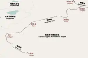
The Southern Xinjiang railway or Nanjiang railway (simplified Chinese: 南疆铁路; traditional Chinese: 南疆鐵路; pinyin: Nánjiāng tiělù), is a railway between Turpan and Kashgar in Xinjiang, China. The railway is 1,446 km (899 mi) in length and runs along the southern slope of the Tian Shan mountain range, connecting all major cities and towns of the Northern Tarim Basin, including Turpan, Hejing, Yanqi, Korla, Luntai (Bügür), Kuqa, Toksu (Xinhe), Aksu, Maralbexi (Bachu), Artux, and Kashgar.[1][2]
| Southern Xinjiang railway 南疆铁路 | |
|---|---|
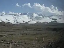
.jpg.webp) The Southern Xinjiang railway through the Tian Shan range in Hejing County | |
| Overview | |
| Status | Operational |
| Locale | |
| Termini | |
| Service | |
| Type | Heavy rail |
| System | |
| Operator(s) | China Railway Ürümqi Group |
| History | |
| Opened | 1984 (Turpan–Korla) 1999 (Korla–Kashgar) |
| Technical | |
| Line length | 1,930 km (1,200 mi) |
| Number of tracks | 2 (Turpan–Aksu; Double-track railway) 1 (Aksu–Kashgar; Single-track railway) |
| Track gauge | 1,435 mm (4 ft 8+1⁄2 in) standard gauge |
| Minimum radius | 800 m (2,625 ft) |
| Electrification | 25 kV AC, 50 Hz (Turpan–Korla) |
| Operating speed | 160km/h |
| Highest elevation | 2.2% |

The line joins the Lanzhou–Xinjiang railway at Turpan (connecting to Ürümqi) and the Kashgar–Hotan railway in Kashgar. It also forms the Taklimakan Desert railway loop, together with sections of the Hotan–Ruoqiang railway, Kashgar–Hotan railway, and Golmud–Korla railway.[3]
History
The Southern Xinjiang railway was built from east to west. The Turpan-Korla section in the east (457 km) was built from 1974 to 1984.[2] The western section from Korla to Kashgar (988 km (614 mi)) was built from 1996 to 1999.[2] From Yanqi to Kashgar, the line follows National Highway 314. The Kashgar–Hotan railway, originally referred to as Phase III of the Southern Xinjiang railway, opened in 2010. From 2008 to 2013, the Korla to Aksu section, 526.9 km (327 mi) in length, was double-tracked.[4]
In December 2014, a second double-track electrified line between Turpan and Korla opened to commercial operation.[5] This new line, called the second Turpan–Korla railway, is 334 km (208 mi) in length.[5] The line makes use of extensive tunneling to shorten the distance between the two cities by 123 km (76 mi).[5] The maximum elevation along route is lowered from 2,980 m (9,777 ft) to 1,490 m (4,888 ft), and the steepest incline is reduced from 22.7‰ to 13‰.[5] The longest tunnel along route, the Middle Tianshan Tunnel, is 22.467 km (14.0 mi) in length and one of the longest railway tunnels in China.[5]
On 1 January 2021, a branch from south of Kalpin to Tumxuk was opened to passenger service. It is 31 kilometres (19 mi) long and has a design speed of 100 kilometres per hour (62 mph).[6]
Station list
| Station | Chinese | Distance (km2) | Location | |
|---|---|---|---|---|
| Turpan Lanzhou–Xinjiang railway | 吐鲁番 | 0 | Gaochang | Turpan |
| Longpan | 龙盘 | |||
| Tiequan | 铁泉 | |||
| Zhenzhuquan | 珍珠泉 | |||
| Hongshanqu | 红山渠 | |||
| Toksun | 托克逊 | Toksun County | ||
| Wangbu | 望布 | |||
| Burjiayi | 布尔加依 | |||
| Yurgou | 鱼儿沟 | Dabancheng | Ürümqi | |
| Zulumutai | 祖鲁木台 | Toksun County | Turpan | |
| Kargante | 喀尔干特 | |||
| Xiageze | 夏格泽 | |||
| Xingyuan | 星源 | |||
| Guoguang | 国光 | Hejing County | Bayingolin Prefecture | |
| Alagou | 阿拉沟 | |||
| Kulin'aman | 库林阿曼 | |||
| Dedaigou | 德代沟 | |||
| Dewentuo | 德文托盖 | |||
| Zhahesala | 扎和萨拉 | |||
| Wusite | 乌斯特 | |||
| Harge | 哈尔格 | |||
| Shengliqiao | 胜利桥 | |||
| Shangxinguang | 上新光 | |||
| Xiaxinguang | 下新光 | |||
| Haranggu | 哈让古 | |||
| Baluntai | 巴伦台 | |||
| Husitai | 胡斯台 | |||
| Daxigou | 大西沟 | |||
| Tianqiaonan | 天桥南 | |||
| Mogatu | 莫嘎图 | |||
| Hejing | 和静 | 369 | ||
| Bakeshu | 八棵树 | |||
| Xingfutan | 幸福滩 | |||
| Yanqi | 焉耆 | 400 | Yanqi County | |
| Baorhai | 包尔海 | |||
| Ziniquan | 紫泥泉 | |||
| Tashidian | 塔什店 | Korla | ||
| Yunya | 云崖 | |||
| Korla | 库尔勒 | 457 | ||
| Kubei | 库北 | |||
| Kuxi | 库西 | |||
| Xiaota | 肖塔 | |||
| Kuluke | 库鲁克 | Luntai County | ||
| Yeyungou | 野云沟 | |||
| Cedaya | 策达雅 | |||
| Yangxia | 阳霞 | |||
| Talake | 塔拉克 | |||
| Luntai | 轮台 | |||
| Erbatai | 二八台 | Kuqa County | Aksu Prefecture | |
| Yakela | 雅克拉 | |||
| Yaha | 牙哈 | |||
| Kuqa | 库车 | 740 | ||
| Kuqa West Kuqa–Ehuobulake Railway | 库车西 | |||
| Xinhe | 新和 | 779 | Xinhe County | |
| Yisekesu | 伊斯克苏 | |||
| Terxike | 特尔希克 | |||
| Yangtake Kuduke | 羊塔克库都克 | |||
| Xianshuigou | 咸水沟 | Wensu County | ||
| Kalayurgun | 喀拉玉尔滚 | |||
| Paman | 帕满 | |||
| Aksu | 阿克苏 | 983 | Aksu | |
| Sanjiaodi | 三角地 | |||
| Jinyinchuan | 金银川 | |||
| Kalpin | 柯坪 | Kalpin County | ||
| Yijianfeng | 一间房 | Bachu County | Kashi Prefecture | |
| Bachu | 巴楚 | 1,200 | ||
| Wudaoban | 五道班 | |||
| Xiger | 西格尔 | Artux | Kizilsu Prefecture | |
| Bapanmo | 八盘磨 | |||
| Artux | 阿图什 | 1,410 | ||
| Kashi Kashgar–Hotan railway | 喀什 | 1,445 | Kashi | Kashi Prefecture |
Rail connections
Gallery
 Train No.K169 running on the railway
 Through the Tian Shan in Hejing County
 Train running between mountains in Toksun County, Turpan
 Hejing County section in winter
See also
References
- (Chinese) "12月6日:南疆铁路全线开通运营" Accessed 2011-01-21
- (Chinese) "南疆铁路" Accessed 2011-01-21
- Zhang, Kate (17 June 2022). "New railway completes 2,700km loop of Taklamakan Desert in move to integrate Xinjiang with rest of China". South China Morning Post.
- (Chinese) 南疆铁路库阿二线开通运营 全长526.9公里 2013-12-05
- (Chinese) 袁蕾, 吐库二线正式开通运营 南疆铁路进入电气化时代 新疆日报 2014-12-29
- "图木舒克铁路开通运营". new.chinaxinjiang.cn. Retrieved 2021-01-04.