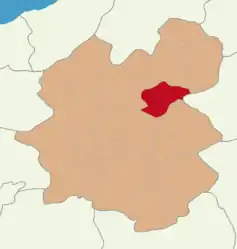
Narman
Narman (Armenian: Նամուրվան; Georgian: ნარიმანი), formerly Namervan and İd, is a municipality and district of Erzurum Province, Turkey.[2] Its area is 799 km2,[3] and its population is 12,292 (2022).[1] The mayor is Burhanettin Eser (AKP).
Narman | |
|---|---|
 Map showing Narman District in Erzurum Province | |
 Narman Location in Turkey | |
| Coordinates: 40°20′50″N 41°52′06″E | |
| Country | Turkey |
| Province | Erzurum |
| Government | |
| • Mayor | Burhanettin Eser (AKP) |
| Area | 799 km2 (308 sq mi) |
| Elevation | 1,640 m (5,380 ft) |
| Population (2022)[1] | 12,292 |
| • Density | 15/km2 (40/sq mi) |
| Time zone | TRT (UTC+3) |
| Postal code | 25530 |
| Area code | 0442 |
| Climate | Dfb |
| Website | www |
Composition
There are 46 neighbourhoods in Narman District:[4]
- Alabalık
- Alacayar
- Araköy
- Aşağıyayla
- Başkale
- Beyler
- Boğakale
- Camikebir
- Camisağır
- Çamlıyayla
- Çimenli
- Dağyolu
- Demirdağ
- Ergazi
- Gökdağ
- Göllü
- Güllüdağ
- Güvenlik
- Kamışözü
- Karadağ
- Karapınar
- Kilimli
- Kışlaköy
- Koçkaya
- Koyunören
- Kuruçalı
- Mahmutçavuş
- Mercimekli
- Otlutepe
- Pınaryolu
- Samikale
- Sapanlı
- Savaşçılar
- Şehitler
- Şekerli
- Serinsu
- Seyyid Ali Baba
- Sülüklü
- Sütpınar
- Taşburun
- Telli
- Toygarlı
- Tuzla
- Yanıktaş
- Yoldere
- Yukarıyayla
References
- "Address-based population registration system (ADNKS) results dated 31 December 2022, Favorite Reports" (XLS). TÜİK. Retrieved 12 July 2023.
- Büyükşehir İlçe Belediyesi, Turkey Civil Administration Departments Inventory. Retrieved 12 July 2023.
- "İl ve İlçe Yüz ölçümleri". General Directorate of Mapping. Retrieved 12 July 2023.
- Mahalle, Turkey Civil Administration Departments Inventory. Retrieved 12 July 2023.
This article is issued from Wikipedia. The text is licensed under Creative Commons - Attribution - Sharealike. Additional terms may apply for the media files.
