National Cartographic Center of Iran
The National Cartography Center of Iran (NCCC, Persian: سازمان نقشه برداری کشور) is the main organization for cartography in Iran. It is administered and funded by the Government of Iran, as part of the Plan and Budget Organization. The NCC was established in 1953.[1][2][3]

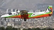
Aircraft Dornier Do-228-212 used by NCC for aerial survey.
| سازمان نقشه برداری کشور | |
 | |
| Agency overview | |
|---|---|
| Formed | 1953 |
| Jurisdiction | Islamic Republic of Iran |
| Headquarters | Tehran, Iran |
| Agency executive |
|
| Website | www |
References
- Brentjes, S. (2009). "Cartography in Islamic Societies". International Encyclopedia of Human Geography. Elsevier. pp. 414–427. doi:10.1016/b978-008044910-4.00002-x. ISBN 978-0-08-044910-4.
- National Report of Geomatics in Islamic Republic of Iran, Nineteenth United Nations Regional Cartographic Conference for Asia and the Pacific. Bangkok, 29 October – 1 November 2012
- Soofi, A.S.; Ghazinoory, S. (2013). Science and Innovations in Iran: Development, Progress, and Challenges. Palgrave Macmillan. p. 196. ISBN 978-1-137-03009-2. Retrieved 2021-01-03.
This article is issued from Wikipedia. The text is licensed under Creative Commons - Attribution - Sharealike. Additional terms may apply for the media files.