Naugatuck Valley Planning Region, Connecticut
The Naugatuck Valley Planning Region is a planning region and county-equivalent in Connecticut. It is served by the coterminous Naugatuck Valley Council of Governments (NVCOG). In 2022, planning regions were approved to replace Connecticut's counties as county-equivalents for statistical purposes, with full implementation occurring by 2024.[1][2]
Naugatuck Valley Planning Region | |
|---|---|
Planning region | |
| Naugatuck Valley Council of Governments (NVCOG) | |
|
Logo | |
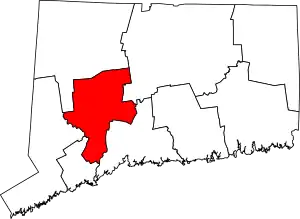 Location within the U.S. state of Connecticut | |
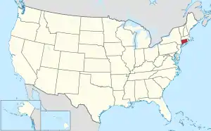 Connecticut's location within the U.S. | |
| Coordinates: 41°31′N 73°07′W | |
| Country | |
| State | |
| Founded | 2013 |
| Largest city | Waterbury |
| Other cities | Bristol, Shelton, Ansonia, Derby |
| Government | |
| • Executive Director | Rick Dunne |
| Area | |
| • Total | 421.84 sq mi (678.89 km2) |
| • Land | 413.14 sq mi (664.88 km2) |
| • Water | 8.7 sq mi (14.01 km2) 97.94% |
| Population (2020) | |
| • Total | 450,376 |
| • Density | 1,090.13/sq mi (420.90/km2) |
| Time zone | UTC−5 (Eastern) |
| • Summer (DST) | UTC−4 (EDT) |
| Congressional districts | 1st, 3rd, 4th, 5th |
| Website | nvcogct |
Demographics
| Census | Pop. | Note | %± |
|---|---|---|---|
| 2020 | 450,376 | — | |
| 2022 (est.) | 454,083 | [3] | 0.8% |
| U.S. Decennial Census[2] | |||
As of the 2020 United States census, there were 450,376 people living in the Naugatuck Valley Planning Region.[2]
Municipalities
The following municipalities are members of the Naugatuck Valley Region:[4]
References
- "Governor Lamont Announces U.S. Census Bureau Approves Proposal for Connecticut's Planning Regions To Become County Equivalents". CT.gov. Retrieved March 24, 2023.
- "Change to County-Equivalents in the State of Connecticut". Federal Register. June 6, 2022. Retrieved March 24, 2023.
- "U.S. Census Bureau QuickFacts: Naugatuck Valley Planning Region, Connecticut; United States". www.census.gov. Retrieved 2023-05-13.
- "Our Region". Naugatuck Valley Council of Governments. Retrieved March 24, 2023.
External links
Municipalities and communities of Naugatuck Valley Planning Region, Connecticut, United States | ||
|---|---|---|
| Cities | | |
| Towns | ||
This article is issued from Wikipedia. The text is licensed under Creative Commons - Attribution - Sharealike. Additional terms may apply for the media files.