Nebraska Highway 5
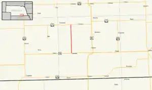
Nebraska Highway 5 (N-5) is a 11.04-mile (17.77 km) state highway in Thayer County, Nebraska, United States, that connects U.S. Route 136 (US 136), just north of Deshler, with Nebraska Highway 4 (N-4), between Davenport and Carleton. N-5 is entirely a two-lane road that runs through rural agricultural area[3] and is part of three National Historic Trails: the Oregon National Historic Trail, the California National Historic Trail, and the Pony Express National Historic Trail.
State Highway 5 | ||||
|---|---|---|---|---|
 Nebraska Highway 5 highlighted in red | ||||
| Route information | ||||
| Maintained by NDOT | ||||
| Length | 11.04 mi[1] (17.77 km) | |||
| Existed | 1940[2]–present | |||
| Major junctions | ||||
| South end | ||||
| North end | ||||
| Location | ||||
| Country | United States | |||
| State | Nebraska | |||
| Counties | Thayer | |||
| Highway system | ||||
| ||||
Route description
N-5 begins at an intersection with US 136 and 1st Street, immediately north of the northern city limits of Deshler. (US 136 heads east [along with the three historic trails] to quickly connect with the north end of Nebraska Spur 85E and on toward Hebron and Fairbury. US 136 heads west toward Ruskin and Red Cloud. 1st Street heads south through Deshler.)[1][3]
From its southern terminus N-5 heads north for about 4.5 miles (7.2 km) before crossing over the Little Blue River. Nearly 2 miles (3.2 km) farther north, N-5 crosses over the South Fork Big Sandy Creek. Continuing north for just over 4 miles (6.4 km), N-5 crosses over two sets of Union Pacific Railroad tracks at a level crossing and then promptly crosses over Big Sandy Creek.[1][3]
About one-half-mile (0.80 km) north of Big Sandy Creek, N-5 reaches its northern terminus at an intersection with N-4 and Road 5400, about 3.2-mile (5.1 km) west of Carleton and 5 miles (8.0 km) east of Davenport. (From the intersection N-4 heads east toward Carleton and Belvidere and west [along with the three historic trails] toward Daveport. Road 5400 heads north toward Shickley.)[1][3]
History
N-5 was originally designated in 1925 from the Kansas state line south of Falls City north through Omaha to the Iowa state line at South Sioux City and the Missouri River, replacing Nebraska Highway 10, Nebraska Highway 11, Nebraska Highway 12, and a portion of Nebraska Highway 13. Around 1933 the original N-5 became part of US Route 73, U.S. Route 75, U.S. Route 77, and Nebraska Highway 9, and the N-5 designation was transferred to its current route in 1940.[2]
Major intersections
The entire route is in Thayer County.
| Location | mi[1] | km | Destinations[3] | Notes | |
|---|---|---|---|---|---|
| | 0.00 | 0.00 | 1st Street south – Deshler | Continuation south from southern terminus | |
| Southern terminus | |||||
| | 4.48 | 7.21 | Bridge over the Little Blue River | ||
| | 11.04 | 17.77 | Northern terminus | ||
| Road 5400 north – Shickley | Continuation north from northern terminus | ||||
| 1.000 mi = 1.609 km; 1.000 km = 0.621 mi | |||||
References
- "Nebraska Highway Reference Log Book" (PDF). roads.nebraska.gov. Nebraska Department of Transportation. October 2019. p. 316. Archived from the original (PDF) on February 15, 2020. Retrieved July 4, 2023 – via Wayback Machine.
- Geelhard, Chris (October 23, 2005). "Nebraska Highways". Archived from the original on June 29, 2011. Retrieved July 4, 2023 – via Wayback Machine.
- Google (July 4, 2023). "overview of Nebraska Highway 5" (Map). Google Maps. Google. Retrieved July 4, 2023.
External links
