Needles Ferry
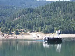
The Needles Ferry is a cable ferry across Lower Arrow Lake in the West Kootenay region of southeastern British Columbia. Linking Needles and Fauquier, the ferry, part of BC Highway 6, is by road about 135 kilometres (84 mi) southeast of Vernon and 57 kilometres (35 mi) southwest of Nakusp.
 Needles Ferry | |
| Locale | Needles−Fauquier |
|---|---|
| Waterway | Lower Arrow Lake |
| Transit type | Passenger and vehicle ferry |
| Carries | |
| Owner | BC Ministry of Transportation and Infrastructure |
| Operator | WaterBridge Ferries Inc. |
| System length | 0.9 km (0.6 mi) |
| No. of lines | 1 |
| No. of vessels | 1 |
| No. of terminals | 2 |
| Website | www2 |
Timeline
1913: Farmers built the first vehicle ferry using Ford Model T parts.[1] Apart from a reference to a rudimentary raft in 1922,[2] no evidence exists of a service most years.[3]
1924: Government ferry launched, which comprised a log raft pushed by a launch.[4] This free service, had a one-car capacity.[5]
1928: Larger boat introduced.[5]
1931: Wooden hulled cable ferry installed,[4] having three-car capacity.[5] Crossings were hourly.[4]
1941: Upgraded to eight-car capacity.[5]
1952: Upgraded to 16-car capacity.[5]
1955: Service increased from 12 to 24 hours per day.[5]
1967: Replacement bridge confirmed, but never eventuated.[6]
1968: Both terminals rebuilt on submerging by the reservoir for the Keenleyside Dam.[7]
1969: Diesel-powered Needles with 28-car capacity introduced.[4]
1990: Needles relocated to Upper Arrow Lake Ferry route. Replaced by a 40-vehicle, 150-passenger cable ferry. At 1,500 metres (5,000 ft) was longest haul cable in North America.[4]
2002: Service reduced to 17 hours per day.[8]
2004: Western Pacific Marine became the service contractor.[9]
c.2013: WaterBridge Ferries became the service provider.
2019: Ferry crew observed a submerged pickup truck just off the Needles ferry landing.[10]
Patronage
| Patronage (1924–1947)a (Double these numbers for single trips) | |||||||||
|---|---|---|---|---|---|---|---|---|---|
| Type | Year | Page | Round Trips | Motor Vehicles | Horse- drawn rigs | Passengers | Freight (tons) | Livestock | Total Vehicles |
| Power boat | 1924–25 | Q38 | 1,008 | 256 | 30 | 2,186 | 682 | 36 | 286 |
| 1925–26 | Q38 | 1,852 | 2,557 | 56 | 4,037 | 42 | 100 | 2,613 | |
| 1926–27 | P46 | 2,264 | 1,604 | 44 | 6,004 | 46 | 96 | 1,648 | |
| 1927–28 | U52 | 7,138 | 1,530 | 40 | 5,162 | 39 | 41 | 1,570 | |
| 1928–29 | S61 | 2,155 | 2,442 | 38 | 5,972 | 89 | 86 | 2,480 | |
| 1929–30 | T74 | 2,155 | 2,366 | 79 | 5,899 | 68 | 87 | 2,445 | |
| Power cable | 1930–31 | G50 | 4,102 | 4,790 | 231 | 11,354 | 340 | 172 | 5,021 |
| 1931–32 | M40 | 4,117 | 5,244 | 385 | 11,836 | 582 | 159 | 5,629 | |
| 1932–33 | Q36 | 4,049 | 4,438 | 369 | 13,203 | 503 | 135 | 4,807 | |
| 1933–34 | O32 | 4,675 | 4,740 | 510 | 14,827 | 784 | 259 | 5,250 | |
| 1934–35 | T37 | 5,427 | 6,181 | 700 | 18,449 | 719 | 605 | 6,881 | |
| 1935–36 | I44 | 5,637 | 6,882 | 661 | 18,834 | 820 | 239 | 7,543 | |
| 1936–37 | X52 | 5,992 | 7,733 | 825 | 19,804 | 998 | 355 | 8,558 | |
| 1937–38 | X55 | 6,823 | 9,046 | 911 | 22,305 | 1,292 | 228 | 9,957 | |
| 1938–39 | Z56 | 6,580 | 9,188 | 758 | 20,605 | 1,830 | 262 | 9,946 | |
| 1939–40 | P56 | 7,220 | 9,346 | 541 | 21,324 | 1,938 | 310 | 9,887 | |
| 1940–41 | O47 | 7,109 | 10,237 | 359 | 18,403 | 1,181 | 360 | 10,596 | |
| 1941–42 | T52 | 6,628 | 10,894 | 229 | 20,010 | 2,116 | 590 | 11,123 | |
| 1942–43 | O52 | 5,764 | 8,318 | 316 | 14,367 | 3,525 | 441 | 8,634 | |
| 1943–44 | Q52 | 4,984 | 7,359 | 225 | 12,679 | 1,730 | 426 | 7,584 | |
| 1944–45 | O51 | 4,985 | 7,284 | 74 | 14,699 | 1,814 | 217 | 7,358 | |
| 1945–46 | Q58 | 5,426 | 8,620 | 264 | 14,037 | 1,707 | 330 | 8,884 | |
| 1946–47 | P47 | 7,262 | 11,971 | 88 | 27,079 | 7,416 | 345 | 12,059 | |
^a . Extracted from the respective Ministry of Public Works annual reports.
| Patronage (1947–1960)b (Double these numbers for single trips) | ||||||||||||||
|---|---|---|---|---|---|---|---|---|---|---|---|---|---|---|
| Type | Year | Page | Round Trips | Passenger Autos | Passengers (Drivers excluded) | Trucks | Trailers & Semis | Buses | Motor- cycles | Horse- drawn rigs | Freight (tons) | Livestock | Misc. Veh. | Total Vehicles |
| Power cable | 1947–48 | N56 | 7,435 | 6,759 | 30,300 | 4,466 | 1,426 | 1,625 | 20 | 146 | 2,750 | 163 | 14,442 | |
| 1948–49 | O60 | 9,953 | 10,558 | 49,803 | 6,427 | 394 | 1,787 | 29 | 164 | 6,361 | 170 | 19,359 | ||
| 1949–50 | Q74 | 12,928 | 15,311 | 60,151 | 9,970 | 433 | 1,737 | 19 | 71 | 6,798 | 140 | 27,541 | ||
| 1950–51 | N77 | 14,437 | 16,854 | 60,045 | 11,635 | 208 | 1,450 | 18 | 74 | 6,179 | 174 | 30,239 | ||
| 1951–52 | P83 | 12,868 | 12,758 | 52,322 | 10,200 | 372 | 1,535 | 10 | 45 | 4,614 | 99 | 24,920 | ||
| 1952–53 | O85 | 12,738 | 13,662 | 50,004 | 9,071 | 852 | 2,067 | 30 | 63 | 5,317 | 136 | 25,745 | ||
| 1953–54 | M93 | 16,009 | 19,216 | 60,776 | 11,911 | 544 | 1,997 | 63 | 18 | 4,560 | 84 | 33,749 | ||
| 1954–55 | K95 | 15,506 | 17,828 | 55,003 | 11,733 | 558 | 2,035 | 26 | 25 | 4,891 | 110 | 32,205 | ||
| 1955–56 | N88 | 14,601 | 16,783 | 48,373 | 10,947 | 379 | 1,661 | 11 | 26 | 67 | 4 | 29,811 | ||
| 1956–57 | J100 | 15,326 | 18,103 | 52,668 | 13,254 | 601 | 919 | 4 | 31 | 60 | 32,912 | |||
| 1957–58 | G53 | 15,428 | 20,400 | 56,907 | 13,420 | 528 | 720 | 10 | 12 | 71 | 6 | 35,096 | ||
| 1958–59 | G36 | 14,226 | 18,863 | 53,049 | 10,515 | 515 | 870 | 12 | 104 | 30,775 | ||||
| 1959–60 | F41 | 15,226 | 20,939 | 53,077 | 11,450 | 561 | 718 | 10 | 8 | 82 | 33,686 | |||
^b . Extracted from the respective Ministry of Public Works or Ministry of Highways annual reports.
Operation
The ferry operates under private contract with the British Columbia Ministry of Transportation and is free of tolls, as are all inland ferries in British Columbia.[11]
Departures are every thirty minutes, from the first at 5 am until the last at 10 pm, with a crossing time of about five minutes. The ferry has capacity for 40 vehicles and 135 passengers.[12]
Footnotes
- Marquardt, Riel (2006). The Backroad Chronicles: Adventure & History in British Columbia. Vol. I. Trafford Publishing. p. 101. ISBN 978-1-4120-5903-9.
- "Daily News". www.library.ubc.ca. 29 Sep 1922. p. 5.
- "Daily News, 1 Sep 1919". www.library.ubc.ca. p. 3.
- Clapp, Frank A. (1991). Ministry of Transportation and Highways, Lake and River Ferries. Ministry of Transportation and Highways. pp. 32–33. ISBN 0-7726-1364-8.
- Edgewood History Book Committee (1991). Just where is Edgewood?. E. G. Milne. p. 59.
- "Nanaimo Daily News, 6 Jun 1967". www.newspapers.com. p. 14.
- "Nelson Star, 30 Jan 2016". www.nelsonstar.com.
- "Vancouver Sun, 9 Apr 2002". www.newspapers.com. p. 20.
The Needles Ferry across Lower Arrow Lake….will also operate a maximum of 17 hours per day instead of the current 21.5 to 24 hours per day.
- "RFP 12-06-2010" (PDF). www.bcferries.com. p. 6 (4).
- "Nelson Star, 10 Dec 2019". www.trailtimes.ca.
- "Inland Ferries". www.gov.bc.ca.
- "Needles Cable Ferry". www.gov.bc.ca.