Nervino Airport
Nervino Airport (IATA: NVN, FAA LID: O02) is a public airport located one mile (1.6 km) east of Beckwourth, serving Plumas County, California, United States. The airport is mostly used for general aviation. It is used for the area's annual fly-in breakfast.
Nervino Airport | |||||||||||
|---|---|---|---|---|---|---|---|---|---|---|---|
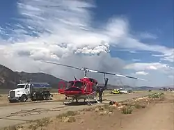 A helicopter at Nervino Airport during the Beckwourth Complex Fire in 2021. | |||||||||||
| Summary | |||||||||||
| Airport type | Public | ||||||||||
| Operator | Plumas County | ||||||||||
| Location | Beckwourth, California | ||||||||||
| Elevation AMSL | 4,900 ft / 1,493.5 m | ||||||||||
| Coordinates | 39°49′07″N 120°21′10″W | ||||||||||
| Website | www | ||||||||||
| Runways | |||||||||||
| |||||||||||
Facilities
Nervino Airport covers 99 acres (400,000 m2) and has one runway:
- Runway 8/26: 4,651 x 75 ft (1,418 x 23 m), surface: asphalt
External links
- Official website
- Resources for this airport:
- FAA airport information for O02
- AirNav airport information for O02
- FlightAware airport information and live flight tracker
- SkyVector aeronautical chart for O02
This article is issued from Wikipedia. The text is licensed under Creative Commons - Attribution - Sharealike. Additional terms may apply for the media files.