Nevşehir Province
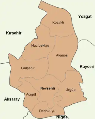
Nevşehir Province (Turkish: Nevşehir ili, from the Persian compound نو شهر Now-shahr meaning "new city") is a province in central Turkey with its capital in Nevşehir. Its area is 5,485 km2,[2] and its population is 310,011 (2022).[1] Its adjacent provinces are Kırşehir to the northwest, Aksaray to the southwest, Niğde to the south, Kayseri to the southeast, and Yozgat to the northeast. Nevşehir includes the area called Cappadocia - a tourist attraction in Turkey. The town of Göreme is also located in Nevşehir.
Nevşehir Province
Nevşehir ili | |
|---|---|
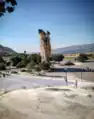
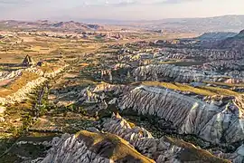 Cappadocia Landscape | |
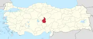 Location of the province within Turkey | |
| Country | Turkey |
| Seat | Nevşehir |
| Government | |
| • Vali | Ali Fidan |
| Area | 5,485 km2 (2,118 sq mi) |
| Population (2022)[1] | 310,011 |
| • Density | 57/km2 (150/sq mi) |
| Time zone | TRT (UTC+3) |
| Area code | 0384 |
| Website | www |
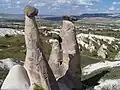
Cappadocia once included the area now covered by this province. This province is notable for the fairy chimneys of Göreme, the Ortahisar (middle fortress), a number of old churches from the Byzantine period.
History
Archaeology
An approximately 5,000-year-old three-story underground town which referred as "Gir-Gör" (Enter and See) by locals was revealed in Avanos in 2019. The five-kilometer-long city consisted of three floors, homes, tunnels, places of worship and a small human figurine. According to the locals, the site was considered a source of "healing water" and "Caesar's bath."[3]
Sports
A multiday track running ultramarathon of desert concept, called Runfire Cappadocia Ultramarathon, is held since 2012 annually in July. The race tours 244 km (152 mi) in six days through several historic places across Cappadocia reaching out to Lake Tuz.[4]
Places of Interest
- Göreme Open Air Museum
- Uçhisar Castle
- Göreme Historical National Park
- Uç Güzeller, "The Three Beauties" fairy chimneys in Ürgüp
- Love Valley
- Zelve Open Air Museum
- Red and Rose Valley
- Ortahisar Castle
- Mustafapaşa
- Meryem Ana Kilisesi, Mother Mary Church near Nevşehir Castle
- the Hagios Georgios Church, also known as the 'Çanlı Church' near Nevşehir Castle
- Avanos, known for its clay pottery.
- St. John the Baptist Chapel
- Aynalı (Fırkatan) Church
- Açık Saray Museum
- Derinkuyu Underground City
- Kaymakli Underground City
- Tatlarin Underground City
- Haji Bektash Veli Complex
Climate
Nevşehir has a continental climate (Köppen climate classification: Dsa, Trewartha climate classification: Dc), with cold, snowy winters and warm, dry summers. Precipitation occurs throughout the year, with a slight peak in spring.
| Climate data for Nevşehir (1991–2020, extremes 1959–2020) | |||||||||||||
|---|---|---|---|---|---|---|---|---|---|---|---|---|---|
| Month | Jan | Feb | Mar | Apr | May | Jun | Jul | Aug | Sep | Oct | Nov | Dec | Year |
| Record high °C (°F) | 18.6 (65.5) |
19.6 (67.3) |
28.0 (82.4) |
31.6 (88.9) |
32.6 (90.7) |
35.0 (95.0) |
39.5 (103.1) |
38.2 (100.8) |
37.4 (99.3) |
32.0 (89.6) |
27.6 (81.7) |
23.0 (73.4) |
39.5 (103.1) |
| Average high °C (°F) | 4.1 (39.4) |
6.0 (42.8) |
10.9 (51.6) |
16.3 (61.3) |
21.2 (70.2) |
25.6 (78.1) |
29.3 (84.7) |
29.4 (84.9) |
25.3 (77.5) |
19.1 (66.4) |
11.6 (52.9) |
6.2 (43.2) |
17.1 (62.8) |
| Daily mean °C (°F) | 0.0 (32.0) |
1.3 (34.3) |
5.5 (41.9) |
10.4 (50.7) |
15.0 (59.0) |
18.9 (66.0) |
22.2 (72.0) |
22.1 (71.8) |
18.1 (64.6) |
12.8 (55.0) |
6.3 (43.3) |
2.0 (35.6) |
11.2 (52.2) |
| Average low °C (°F) | −3.5 (25.7) |
−2.6 (27.3) |
1.0 (33.8) |
5.2 (41.4) |
9.3 (48.7) |
12.3 (54.1) |
14.6 (58.3) |
14.5 (58.1) |
11.3 (52.3) |
7.4 (45.3) |
2.1 (35.8) |
−1.4 (29.5) |
5.9 (42.6) |
| Record low °C (°F) | −21.2 (−6.2) |
−23.6 (−10.5) |
−18.0 (−0.4) |
−12.5 (9.5) |
−2.3 (27.9) |
1.3 (34.3) |
3.8 (38.8) |
3.1 (37.6) |
−1.2 (29.8) |
−7.6 (18.3) |
−14.0 (6.8) |
−19.5 (−3.1) |
−23.6 (−10.5) |
| Average precipitation mm (inches) | 43.7 (1.72) |
41.8 (1.65) |
47.5 (1.87) |
45.7 (1.80) |
57.4 (2.26) |
37.5 (1.48) |
9.9 (0.39) |
9.6 (0.38) |
13.7 (0.54) |
29.4 (1.16) |
33.4 (1.31) |
48.4 (1.91) |
418.0 (16.46) |
| Average precipitation days | 8.80 | 7.83 | 10.27 | 11.33 | 13.40 | 8.40 | 2.40 | 2.37 | 3.83 | 6.93 | 7.10 | 9.30 | 92.0 |
| Mean monthly sunshine hours | 96.1 | 118.7 | 164.3 | 204.0 | 257.3 | 309.0 | 365.8 | 347.2 | 276.0 | 195.3 | 138.0 | 86.8 | 2,558.5 |
| Mean daily sunshine hours | 3.1 | 4.2 | 5.3 | 6.8 | 8.3 | 10.3 | 11.8 | 11.2 | 9.2 | 6.3 | 4.6 | 2.8 | 7.0 |
| Source: Turkish State Meteorological Service[5] | |||||||||||||
Gallery
 Fairy chimneys in Ürgüp
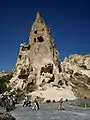 Rock formation in Goreme Open Air Museum
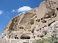 A view from Tatlarin, Nevşehir
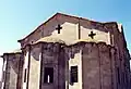 A historical church in Derinkuyu
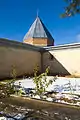
 Ortahisar overlook.
References
- "Address-based population registration system (ADNKS) results dated 31 December 2022, Favorite Reports" (XLS). TÜİK. Retrieved 19 September 2023.
- "İl ve İlçe Yüz ölçümleri". General Directorate of Mapping. Retrieved 19 September 2023.
- Agencies, Daily Sabah with (2019-06-08). "Mysterious flooding leads to discovery of 5,000-year-old underground city in Turkey's Cappadocia". Daily Sabah. Retrieved 2020-09-17.
- "Elite Athletes to run at The Runfire Cappadocia". Istanbul Convention & Visitors Bureau. July 2013. Archived from the original on 2013-08-05. Retrieved 2013-11-28.
- "Resmi İstatistikler: İllerimize Ait Mevism Normalleri (1991–2020)" (in Turkish). Turkish State Meteorological Service. Retrieved 6 July 2021.
External links
- (in Turkish) Nevşehir governor's official website
- (in Turkish) Nevşehir municipality's official website
- (in English) Nevşehir weather forecast information
