Newtowngore
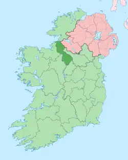
Newtowngore or Newtown Gore, known before the Plantations of Ireland as Ducarrick (Irish: An Dúcharraig, meaning 'the black rock'),[1] is a village on the R199 regional road in County Leitrim, in the north of the parish of Carrigallen.[2]
Newtowngore
An Dúcharraig | |
|---|---|
Village | |
 Shop and post office in Newtowngore | |
 Newtowngore Location in Ireland | |
| Coordinates: 54°02′35″N 7°40′23″W | |
| Country | Ireland |
| Province | Connacht |
| County | County Leitrim |
| Time zone | UTC+0 (WET) |
| • Summer (DST) | UTC-1 (IST (WEST)) |
History
Early history
There is evidence of a number of ringforts in the immediate vicinity of the village, in the townlands of Carrickateane, Mullyaster, Tully North and Killydrum.[3]
According to the 9th-century Tripartite Life of St Patrick, when Saint Patrick was on his way to Magh Slecht to destroy Crom Cruaich, he founded a church and ordained a priest to look after it named Bruscus. The site of this Patrician church is thought to have been near Newtowngore. The ruin in the grounds of the present Church of Ireland church in Newtowngore is likely the medieval church of Moy, which was dedicated to Saint Patrick. Apart from this, nothing is known of the early ecclesiastical history of Carrigallen. There are two holy wells dedicated to the saint, one in Aughawillan and the second in Beaghmore. Nearby the latter is a wart stone where people used to make the cure of the warts by washing them in the water which lay in a hollow in the stone in Moy Abbey in 1345.
19th century
As of the mid-19th century, and as recorded in Samuel Lewis's Topographical Dictionary of Ireland (1837), the parish was then made up of 1,500 statute acres, including a "great quantity of bog". At that time, the village contained about 100 houses and had a "market for grain and provisions on Monday" with fairs "held in April, 4 May, 9 August, 8 October, and the last Friday in December". Throughout at least the 19th and 20th centuries, a number of fair days were held at Newtowngore on- 25 February, 25 May, 26 June (or 28th), 25 August, 15 October, and 25 November.[4][5]
As of the mid-19th century, there was "penny post to Killeshandra and Ballinamore; and a constabulary police force [had] been stationed here".[6]
Woodford Estate
Woodford (Estate) Collins – Robert Collins was the lessor of several townlands in the parishes of Drumreilly and Oughteragh, baronies of Carrigallen and Mohill, at the time of Griffith's Valuation.
(Estate) de Courcey – The de Courcey family held land in the parish of Drumreilly, barony of Dromahaire in the mid-nineteenth century.
The de Courcey family held land in the parish of Drumreilly, barony of Dromahaire in the mid-nineteenth century.
(Estate) Palmer (Leitrim) – The Palmer family were resident at Sriff or Shriff from at least the end of the eighteenth century. They held lands in the parishes of Drumlease and Drumreilly, barony of Dromahaire in the mid-nineteenth century. Henry Manly Palmer of Sriff was a member of the Grand Jury for Leitrim in 1851. Isabella Palmer of Drumkeel is recorded as owning over 1,300 acres (5.3 km2) in Leitrim in 1876. Thomas Robert Palmer, living at Friarstown in the 1870s, owned over 1,600 acres (6.5 km2) in County Leitrim at that time. This family intermarried with the Cullen family of County Leitrim on a number of occasions.
Amenities
Newtowngore has a Church of Ireland church (dedicated to Saint Patrick),[7] a national (primary) school,[8] a small number of shops and (as of early 2019) a post office.[9]
Public transport
Bus Éireann route 462 serves the village on Saturdays providing a link to Sligo via Ballinamore and Drumshanbo.[10]
References
- "An Dúcharraig / Newtowngore". logainm.ie. Placenames Database of Ireland. Retrieved 31 January 2020.
- "Newtown Gore, Ireland". fallingrain.com.
- Recorded Monuments Protected under Section 12 of the National Monuments (Amendment) Act, 1994 – County Leitrim (PDF) (Report). Office of Public Works. 1995. p. 26.
- Longman (1819). Traveller's New Guide Through Ireland, Containing a New and Accurate Description of the Roads (digitized from original in Lyon Public Library [2011] ed.). Longman. p. 405.
- Watsons (1830). The Gentleman's and citizen's almanack ... for the year (PDF). Dublin, Printed for S. Watson [etc.]
- Lewis, Samuel (1837). A topographical dictionary of Ireland comprising the several counties, cities, boroughs corporate, market, and post towns, parishes and villages. Lewis. p. 279.
- "St. Patrick's Church of Ireland Church, Newtowngore, County Leitrim". buildingsofireland.ie. National Inventory of Architectural Heritage. Retrieved 31 January 2020.
- "Newtowngore National School". newtowngorens.ie. Retrieved 31 January 2020.
- "Newtowngore Post office set to continue serving customers until 2019". leitrimobserver.ie. Leitrim Observer. 8 August 2018. Retrieved 31 January 2020.
- "Timetable – Route 462" (PDF). Archived from the original (PDF) on 24 January 2013. Retrieved 4 May 2013.
