Ngweshe Chiefdom
The Ngweshe Chiefdom (French: Chefferie de Ngweshe) is a traditional administrative unit located in Walungu Territory, within the South Kivu Province of the Democratic Republic of the Congo (DRC). It shares borders with Kabare Territory to the north, Rwanda and Burundi to the northeast, Mwenga Territory and Shabunda Territory to the south, and Kaziba Chiefdom to the east.[2] According to the territory's 2018 annual report, the chiefdom has an estimated population of 672,436.[1]
Ngweshe Chiefdom | |
|---|---|
| Chefferie de Ngweshe | |
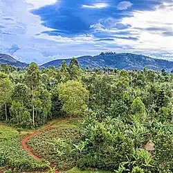
 The landscape view of Ngweshe Chiefdom | |
| Country | |
| Province | South Kivu Province |
| Territory | Walungu Territory |
| Government | |
| • Mwami | Pierre Ndatabaye Weza III |
| Area | |
| • Total | 1,599 km2 (617 sq mi) |
| Population (2018)[1] | |
| • Total | 672,436 |
| Time zone | UTC+2 (CAT) |
| Official language | French |
| National language | Kiswahili |
The chiefdom is home to the Bashi people, who are the predominant ethnic group in the region. The traditional chief, known as the "Mwami," serves as the authority figure, responsible for maintaining law and order, resolving disputes, and preserving the customs and traditions of the Bashi people. The Mwami acts as a respected leader and plays a crucial role in promoting social cohesion and the well-being of the community.[3][4][5]
Geography
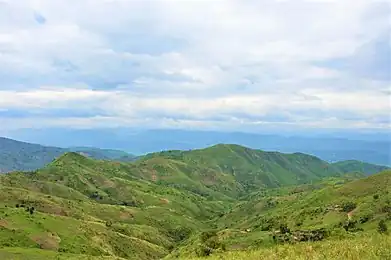
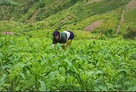
The Ngweshe Chiefdom is situated between 2°35' South latitude and 28°40' East longitude, with an altitudinal gradient ranging from 1000m to 2500m. It is located within the larger Walungu Territory in the South Kivu Province of the DRC, covering a vast area of 1,599 km2.[6] The region's topography consists mainly of rolling hills that stretch across the landscape, interspersed with fertile valleys ideal for agriculture. These valleys play a crucial role in supporting the chiefdom's agrarian activities and local communities. Additionally, the area is rich in forests, boasting diverse flora and fauna, and encompasses considerable plateaus. Approximately half of the chiefdom's land is situated within the Ruzizi Plain, where prominent areas such as Kamanyola, Burhale, Kaniola, Mulambi, Ngando, Irongo, and Karhongo thrive in agriculture.[2][7][8]
Hydrology

The area boasts a vast hydrographic features comprising numerous rivers that flow through its terrain. The Mubimbi River courses through the chiefdom, collecting water from various tributaries, streams, and smaller rivers along its path, ensuring a steady year-round water flow. This river serves as a vital source of irrigation for agricultural activities. Correspondingly, the Nshesha River flows through the Ngweshe Chiefdom, receiving water from its own network of tributaries and smaller streams. It nourishes the surrounding lands and contributes to the overall water resources. The convergence of the Mubimbi and Nshesha Rivers ultimately forms the Ulindi River. This major waterway acts as a vital tributary of the Congo River, one of Africa's longest and most significant rivers. The chiefdom's northern border is formed by the Bishalalo River in the Karhongo groupement, which separates it from the Mumosho groupement in Kabare Territory. The chiefdom is also crossed by the Luzinzi River and the Mugaba River in the Karhongo groupement, and to the east, it is traversed by the Ruzizi River, which acts as a natural border with the Republic of Rwanda.[9][10][8][2][11]
Climate
The Ngweshe Chiefdom experiences a humid subtropical climate with distinct dry and rainy seasons.[12][13] The dry season is characterized by elevated temperatures and a limited amount of rainfall.
During this period, the weather tends to be hot and arid, with a scarcity of precipitation. The dry season provides favorable conditions for certain agricultural practices, particularly the cultivation of marshy areas. Farmers take advantage of the reduced water levels in these regions to engage in activities such as rice farming or other crops that thrive in drier conditions. The average annual temperature in Ngweshe falls within the range of 19 °C to 23 °C, providing a generally mild and comfortable climate throughout the year. However, during the dry season, temperatures can rise to higher levels, with occasional heatwaves that further contribute to the aridity of the region. In contrast to the dry season, Ngweshe experiences a significant amount of rainfall during the rainy season. This period is characterized by increased humidity and more frequent precipitation. The rains rejuvenate the landscape, replenishing the water sources, and nourishing the agricultural fields. The region's flora and fauna also thrive during this time, benefiting from the abundant moisture. The specifics of the rainy season, such as its duration and intensity, may vary from year to year.[6][13]
Geology
The chiefdom exhibits a diverse range of soil types. The predominant soils consist of clayey-sandy red laterite, loose black soils, stony soils, and alluvial soils found in marshes and lowlands. However, these soils are incrementally impoverished due to erosion and overpopulation, leading to numerous land disputes within the area. The presence of clayey soil exacerbates the region's challenges. Some areas have steep slopes, while others feature rugged terrain, such as Kaniola, Izege, Luciga, Karhongo, Rubimbi, and Mushinga. In the lowlands, Ngweshe is home to four significant marshes: Cidorho, Nyamubanda, Cisheke, and Nyalugana. Collectively spanning over 4,000 hectares, these marshes play a crucial role in the local ecosystem. However, soil degradation and population pressure have likely impacted the overall health of these marshes negatively. The consequences of soil degradation and overpopulation are particularly evident in the decline of livestock farming in Ngweshe. The scarcity of pasture lands has led to a noticeable decrease in livestock numbers, posing a challenge to the traditional livelihoods of the local communities.[6]
Administrative division
The Ngweshe Chiefdom is divided into groupements (groupings or groups), each governed by a customary chief (chef de groupement) appointed by the paramount chief. Groupements are often composed of several villages, each of which is also governed by a customary chief. Additionally, each groupement consists of several villages.[14][2]
Groupements
As of 2018, the Ngweshe Chiefdom comprised 16 groupements (groupings):[15]
- Burhale
- Ikoma
- Irongo
- Izege
- Kamanyola
- Kamisimbi
- Kanyola/Kaniola Groupement
- Karhongo
- Lubona
- Luchiga
- Lurhala
- Muchinga
- Mulamba
- Nduba
- Rubimbi
- Walungu
History
The Ngweshe Chiefdom emerged as a small domain governed by a traditional chieftain. Its establishment as a recognized entity can be traced back to the authoritative decrees made by prominent figures of the time. Notably, on October 20, 1920, the District Commissioner, Beau de Ghiuste, officially recognized the Ngweshe Chiefdom through decision n°54, bestowing formal acknowledgment of its existence within the administrative framework. To further consolidate the legitimacy and administrative status of the chiefdom, another critical decision was made on September 23, 1944, by Mr. Ryck, a District Commissioner. His decision supplemented and reinforced the recognition of the Ngweshe Chiefdom, reaffirming its place within the administrative hierarchy and solidifying its position as a recognized entity within the Kivu Region.[16]
Security problems
During the Rwandan genocide, the Ngweshe Chiefdom faced significant security challenges. In response to the Interahamwe and Hutu refugees seeking shelter, Mobutu Sese Seko extended refuge, provoking an invasion of the Democratic Republic of the Congo by Rwanda and Uganda in 1996, known as the First Congo War. The Alliance of Democratic Forces for the Liberation of Congo-Zaire (AFDL), led by Laurent-Désiré Kabila and supported by units of the Rwandan Patriotic Army (RPA), and Forces Armées Burundaises (FAB), carried out brutal actions within the chiefdom and its adjoining areas. They dismantled refugee camps and perpetrated massacres and small-scale killings across various regions of eastern DRC, particularly in Uvira, Bukavu, Fizi, Walungu, Kabare, Kalehe, Shabunda, Goma, Rutchuru, Mugunga, Lac Vert, Masisi, Walikale, Tingi-Tingi, Amisi, Pangi, Kasongo, and Kindu. The AFDL and RPA forces destroyed Hutu makeshift camps and committed massacres in Uvira Territory, advancing towards Bukavu. They targeted the camps created by refugee survivors of massacres in the Ruzizi Plain and the west of Bukavu city.[17][18]

In specific instances, the AFDL/RPA troops attacked a refugee camp in the Kamanyola groupement on October 20, 1996, resulting in the deaths of an unknown number of refugees and Zairian civilians. Subsequently, on October 21, they killed an unknown number of refugees in Nyarubale in the Kalunga hills, as the refugees attempted to reach Bukavu.[19] The AFDL/RPA units also killed several hundred refugees fleeing along routes between Nyantende and Walungu-Centre, as well as Nyantende and Bukavu, predominantly targeting women, children, and the elderly. These attacks involved shootings, bayonet strikes, shrapnel, and the deliberate burning of refugee sites. Incidentally, the Chimanga camp, located seventy-one kilometers west of Bukavu, witnessed the killing of several hundred refugees by AFDL/RPA units around November 22, 1996. According to the United Nations Mapping Report, between 500 and 800 refugees lost their lives in this incident.[19] In January 1997, along the Bukavu to Walungu road, approximately sixteen kilometers from Bukavu city, the AFDL/RPA units killed at least thirty Rwandan and Burundian refugees, mostly employing knives.[19]
The security situation worsened during the Second Congo War, as elements of the Rally for Congolese Democracy (RCD) and RPA recruited numerous young minors, including those from Ngweshe Chiefdom. Initially, voluntary recruitment campaigns were launched, targeting parents. However, due to limited success, forced recruitment became prevalent, with children being kidnapped from schools and markets. These abducted minors were then subjected to military training in DRC or Rwanda under the orders of the RPA. As of 2002, over a thousand minors were still enlisted in the ranks of the RCD.[20] Forced recruitment of children persisted until at least June 2003 when the conflict concluded with the signing of the Global and Inclusive Agreement and the establishment of a transitional government. However, the aftermath of these wars continues to impact the region, with enduring consequences of violence, displacement, and trauma that the communities of Ngweshe Chiefdom continue to grapple with.[20][21][22][23]
See also
References
- "Sources of Conflict In Walungu Territory: Kalinzi, Maji and Mujakazi" (PDF). Arlington County, Virginia, United States: Management Systems International (MSI). August 21, 2019. p. 3. Retrieved 2023-07-17.
- Mapatano, Bagalwa; Bahuga, Bapolisi; Muhigwa, Bahananga; Mwapu, Isumbisho (October 2015). Cahiers du CERPRU (in French). Paris, France: Publibook/Société écrivains. p. 295. ISBN 9782342043334.
- Nkunzi Baciyunjuze, Justin (2005). La naissance de l'eglise au Bushi: l'ère des pionniers 1906-1908 (in French). Rome, Italy: Pontificia Università Gregoriana. pp. 17–36. ISBN 9788878390492.
- Kasimba, Yogolelo Tambwe Ya (1990). "Essai d'Interprétation du Cliché de Kangere (Dans la Région des Grands Lacs Africains)". The Journal of African History. 31 (3): 353–372. doi:10.1017/S0021853700031133. ISSN 0021-8537. JSTOR 182875. S2CID 159945462.
- "Ndatabaye Ngweshe weza III Pierre: "Chez nous les Bashi, la parole du chef est sacrée et doit être respectée"". Radio Okapi (in French). 2015-08-24. Retrieved 2023-07-15.
- Isumbisho, Mwapu; Balagizi, Karhagomba; Mapatano, Mulume; Niyonkuru, Deogratias (March 2013). Gouvernance des Ressources Naturelles Collectives des Ecosystèmes Fragiles dans la Région des Grands Lacs Africains (in French). Bukavu, South Kivu Province, Democratic Republic of the Congo: Les Editions du Centre de Recherches Universitaires du Kivu (CERUKI). pp. 271–281.
- Sefu, Aruna; Musailwa, Kimenya; Tanya, Bitundu Mwanya; Mondonge, M’opandu; Mukenge, Lwimo; Gentil, Kambale Kavusa; Mangambu Mokoso, Jean De Dieu (26 July 2020). "CLIMATE RISKS ASSESSMENT, OPPORTUNITIES RELATED TO THE EVOLUTION OF ECOSYSTEMS AND LIMITATION OF THE PROVISION OF ECOSYSTEM SERVICES: LANDSCAPE CASE OF SOUTH-KIVU (ALBERTINE RIFLT, DRC)". International Journal of Research -GRANTHAALAYAH. Retrieved 16 July 2023.
- "Sources of Conflict In Walungu Territory: Kalinzi, Maji and Mujakazi" (PDF). Management Systems International. August 21, 2019. pp. 3–5. Retrieved 2023-07-15.
- Congo; revue générale de la colonie belge, algemeen tijdschrift van de belgische kolonie: Volume 2, Issue 2 (in French). Brussels, Belgium: Société Belge d'Études Coloniales. 1921. p. 659.
- Traveler's Guide to the Belgian Congo and Ruanda-Urundi. Brussels, Belgium: Tourist Bureau for the Belgian Congo and Ruanda-Urundi. 1956. p. 538.
- Chuma, Géant Basimine; Mondo, Jean Mubalama; Ndeko, Adrien Byamungu; Mugumaarhahama, Yannick; Bagula, Espoir Mukengere; Blaise, Mulalisi; Valérie, Muhaya; Jacques, Kavimba; Karume, Katcho; Mushagalusa, Gustave Nachigera (2021-06-01). "Forest cover affects gully expansion at the tropical watershed scale: Case study of Luzinzi in Eastern DR Congo". Trees, Forests and People. 4: 100083. doi:10.1016/j.tfp.2021.100083. ISSN 2666-7193.
- Post Report. Harry S Truman Building, Northwest, Washington, D.C., U.S.: United States Department of State (DOS). 1980. p. 17.
- Lynch, John Vincent; Ferree, Paul J. (1961). The Agricultural Economy of Bolivia. Washington, D.C.: Economic Research Service (ERS). p. 28.
- "Loi organique n° 08/016 du 07 octobre 2008 portant composition, organisation et fonctionnement des Entités Territoriales Décentralisées et leurs rapports avec l'Etat et les Provinces". www.leganet.cd. Retrieved 2023-07-16.
- "Annexe IV: De la repartition des sieges pour l'election des conseillers de secteur ou de chefferie" (PDF). www.ceni.cd (in French). Kinshasa, Democratic Republic of the Congo. September 20, 2018. p. 375. Archived from the original (PDF) on 2018-09-20. Retrieved 2023-07-16.
- "Rapport final des consultations participatives de la base pour l'élaboration du Document de Stratégies de Réduction de la Pauvreté (DSRP): Territoire de Walungu - Province du Sud Kivu" (PDF). The University of Texas at Austin (in French). Austin, Texas, United States. 2004. p. 17. Retrieved 2023-07-16.
- "First Congo War - Attacks against Hutu refugees". Retrieved 2023-07-16.
- Cooper, Tom (2013). Great Lakes Holocaust: The First Congo War, 1996-1997. Havertown, Pennsy, lvania: Casemate Publishers. pp. 37–50. ISBN 9781909384651.
- "Attacks against Hutu refugees - Walungu and Kabare (South Kivu)". Retrieved 2023-07-16.
- "Second Congo War – Attacks on other civilian populations – South Kivu". Retrieved 2023-07-16.
- "Sources of Conflict In Walungu Territory: Kalinzi, Maji and Mujakazi" (PDF). Management Systems International. August 21, 2019. Retrieved 2023-07-16.
- "Sud-Kivu : insécurité sur l'axe Bukavu-Walungu, un mort". Radio Okapi (in French). 2021-09-29. Retrieved 2023-07-16.
- "Nouvel accrochage entre l'armée et les Maï-Maï Raïa Mutomboki à Walungu". Radio Okapi (in French). 2017-08-16. Retrieved 2023-07-16.
