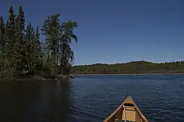
Nistosap Lake
Nistosap Lake is a glacial lake on the Mistik Creek chain, approximately 22 kilometres (14 mi) northeast of Bakers Narrows. As a segment of the Mistik Creek, it is part of the Nelson River watershed, in the Hudson Bay drainage basin in the Northern Region of Manitoba, Canada.
| Nistosap Lake | |
|---|---|
 Nistosap Lake | |
 Nistosap Lake | |
| Location | Manitoba |
| Coordinates | 54°49′29″N 101°24′59″W |
| Lake type | Glacial Lake |
| Primary inflows | Mistik Creek |
| Primary outflows | Mistik Creek |
| Basin countries | Canada |
| Max. length | 1.5 km (0.93 mi) |
| Max. width | .7 km (0.43 mi) |
| Surface elevation | 326 m (1,070 ft) |
| Islands | 2 |
The surrounding mixed deciduous and coniferous forest is part of the Churchill River Upland portion of the Midwestern Canadian Shield forests.[1] The region around the lake consists of rocky parallel ridges with poorly drained areas of muskeg and irregular stony shorelines due to intense glaciation.[2] The lake is situated on the well known "Mistik Creek Loop", a remote canoe route 80 kilometres (50 mi) in length which can be paddled in four days.[3][4]
Nistosap means 'thirteen' in Cree, as all of the fourteen lakes on Mistik Creek are named in numeric order in Cree.[1][5]
See also
References
- Manitoba Conservation and Water Stewardship (Summer 2012). Neso Lake Provincial Park Draft Management Plan (PDF). Manitoba Conservation and Water Stewardship. p. 2. Archived from the original (PDF) on 2016-03-04. Retrieved 2017-09-06.
- Lee, Eun (2000). "Temporal Distribution of Ectomycorrhizzal Fungi and Pollen" (PDF). Korean Journal of Ecology. 23 (2): 169–173. Retrieved 18 May 2014.
- Schick, RoseAnna (2003-06-21). "Live the song of the paddles". Winnipeg Free Press. Retrieved 18 May 2014.
- Berard, Real (1968). Mistik Creek Canoe Route. Manitoba Dept. of Natural Resources. Archived from the original on 2014-05-18.
- Place-Names of Manitoba. Canadian Board on Geographical Names. 1933. p. 67.