Noisy-le-Grand – Mont d'Est station
Noisy-le-Grand–Mont d'Est is a train station in Noisy-le-Grand, Seine-Saint-Denis, under Les Arcades department store.[1]
Noisy-le-Grand–Mont d'Est | |||||||||||
|---|---|---|---|---|---|---|---|---|---|---|---|
| RER station | |||||||||||
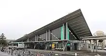
.JPG.webp) The building seen from the bus station. | |||||||||||
| General information | |||||||||||
| Location | France | ||||||||||
| Coordinates | 48.8406°N 2.5481°E | ||||||||||
| Owned by | RATP Group | ||||||||||
| Operated by | RATP Group | ||||||||||
| Line(s) | |||||||||||
| Platforms | 2 | ||||||||||
| Tracks | 3 | ||||||||||
| Other information | |||||||||||
| Station code | 87758334 | ||||||||||
| Fare zone | 4 | ||||||||||
| History | |||||||||||
| Opened | 9 December 1977 | ||||||||||
| Passengers | |||||||||||
| 2019 | 7,609,131 | ||||||||||
| Services | |||||||||||
| |||||||||||
Description
The station is in the Mont d'Est district of Noisy-le-Grand, under Les Arcades department store. One can walk from the station to the mall without going outside.
History
The station opened in 1977 as RER line A was officially created.
During the 1990s, a SK people mover was supposed to link the station and office blocks, but the project failed.[2] However, the line was created and the ghost station still exists.[3]
Traffic
As of 2019, the estimated annual attendance by the RATP Group was 7,609,131 passengers.[4]
Transport service
Train
Noisy-le-Grand–Mont d'Est is served by RER line A. The average waiting time for trains to Paris and Marne-la-Vallée–Chessy is 10 minutes. During peak hours, some trains from Paris terminate there.
Bus connections
The station is served by several buses:
 RATP Bus network lines: 120 (to Nogent-sur-Marne), 206 (to Emerainville and Pontault-Combault), 207 (to La-Queue-en-Brie), 303 (to Bobigny), 306 (to Saint-Maur – Créteil), 310 (to Noisy – Champs and to Les Yvris–Noisy-le-Grand) and 320 (a circular line serving several districts of Noisy-le-Grand) ;[5]
 Noctilien network night bus lines: N34 (between Paris (Gare de Lyon) and Torcy) and N130 (between Paris (Gare de Lyon) and Marne-la-Vallée–Chessy - Disneyland).[6]
Gallery
 Main entrance to the station
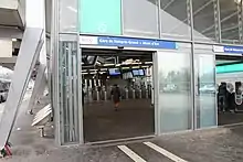
(with the bus station partly visible) Main entrance and hall of the station
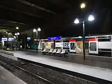
 Train serving the station
(towards Paris)
References
- "Department Stores, Shopping Centres & Galleries, The Business Directory: Paris & Ile de France, France". Angloinfo. Angloinfo. Retrieved 8 June 2016.
- "Le fiasco du mini-métro de Noisy-le-Grand". leparisien.fr (in French). Retrieved 2015-12-25.
- Métro SK de Noisy-le-Grand–YouTube, retrieved 2015-12-25
- "Trafic annuel entrant par station du réseau ferré 2019". Open Data RATP (Data.Ratp.fr) (in French). RATP Group. Retrieved 8 August 2021.
- "Plan du réseau de bus à Marne-la-Vallée (Secteur n°11)" [Map of the RATP bus network in Marne-la-Vallée (Sector n° 11).] (PDF). Ratp.fr (Color map showing the names of bus stops and main streets.) (in French). RATP Group. May 2020. Retrieved 19 August 2020.
- "Plan du réseau Noctilien (2017) - (Secteur : Paris & Sud-Est)" [Map of the night bus (Noctilien) network (2017) - (Sector: Paris and its south-eastern suburbs).] (PDF). Ratp.fr (Color map showing the names of the bus stops and the cities served.) (in French). RATP Group. April 2017. Retrieved 19 August 2020.