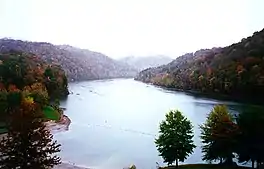
Nolin River Lake
Nolin River Lake is a reservoir in Edmonson, Grayson, and Hart counties in Kentucky. It was impounded from the Nolin River by the United States Army Corps of Engineers in 1963.[2] The Nolin River dam was authorized in 1938 as part of a flood control act. The lake varies from 2,890 acres (11.7 km2) in the winter to 5,795 acres (23.45 km2) in the summer.
| Nolin River Lake | |
|---|---|
 | |
 Nolin River Lake | |
| Location | Edmonson / Grayson / Hart counties, Kentucky, US |
| Coordinates | 37°18′40.81″N 86°14′15.09″W |
| Type | reservoir |
| Primary inflows | Nolin River |
| Primary outflows | Nolin River |
| Basin countries | United States |
| Surface elevation | 515 ft (157 m)[1] |
Nearby attractions include Mammoth Cave National Park, Nolin Lake State Park, Moutardier Resort and Marina, Ponderosa Boat Dock/Marina and Wax Marina. Moutardier is an unincorporated community that abuts Nolin River Lake. Moutardier is located on Kentucky Route 259, 10.3 miles (16.6 km) south-southeast of Leitchfield.[3]
References
- U.S. Geological Survey Geographic Names Information System: Nolin River Lake
- Kleber, John E., ed. (1992). "Lakes". The Kentucky Encyclopedia. Associate editors: Thomas D. Clark, Lowell H. Harrison, and James C. Klotter. Lexington, Kentucky: The University Press of Kentucky. ISBN 0-8131-1772-0.
- State Primary Road System: Grayson County (PDF) (Map). Kentucky Transportation Cabinet. 2011. Retrieved April 30, 2013.
External links
- US Army Corps of Engineers page on Nolin Lake
- Nolin Lake State Park facilities map
- Nolin Lake State Park interactive GIS map
This article is issued from Wikipedia. The text is licensed under Creative Commons - Attribution - Sharealike. Additional terms may apply for the media files.
