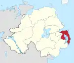
Ards and North Down
Ards and North Down is a local government district in Northern Ireland. It was created on 1 April 2015 by merging the Borough of Ards and the Borough of North Down. The local authority is Ards and North Down Borough Council.
Ards and North Down
| |
|---|---|
District | |
 | |
| Sovereign state | United Kingdom |
| Constituent country | Northern Ireland |
| Status | District |
| Admin HQ | Bangor |
| Incorporated | 1 April 2015 |
| Government | |
| • Type | District council |
| • Body | Ards and North Down Borough Council |
| Area | |
| • Total | 177.0 sq mi (458.3 km2) |
| Population (2021) | |
| • Total | 163,827 |
| • Density | 930/sq mi (360/km2) |
| Time zone | UTC0 (GMT) |
| • Summer (DST) | UTC+1 (BST) |
| Ethnicity | 97.7% White[2] |
| Website | http://www.ardsandnorthdown.gov.uk/ |
Geography
The new district is in the East of Northern Ireland, covering the Ards Peninsula, most of Strangford Lough and the southern shore of Belfast Lough. It has an estimated population of 163,827.[3] The original name of the new district was recommended on 17 September 2008.[4]
Council
Ards and North Down Borough Council replaces Ards Borough Council and North Down Borough Council. The first election for the new district council was originally due to take place in May 2009, but on April 25, 2008, Shaun Woodward, Secretary of State for Northern Ireland, announced that the scheduled 2009 district council elections were to be postponed until 2011.[5] The first elections took place on 22 May 2014 and the council acted as a shadow authority until 1 April 2015.
At a meeting of the shadow authority on 15 December 2014, councillors voted in favour of changing the council's name to East Coast Borough Council, and to submit an application to the Department of the Environment to change the name with effect as of 1 April 2015.[6] However, the council's website launched on 1 April 2015 refers to the new council as "Ards and North Down Borough Council", and this name has continued in use.
Freedom of the Borough
The following have received the Freedom of the Borough of Ards and North Down.
Individuals
- Gary Lightbody OBE: 30 August 2022.[7]
Military Units
- The Irish Guards: 24 June 2022.[8]
Organisations and Groups
- The South Eastern Health and Social Care Trust: 1 September 2018.[9]
See also
References
- "LGBC Moltaí Leasaithe Athbhreithniú 2021-2022" (PDF). Local Government Boundaries Commissioner for Northern Ireland. 18 January 2022. Retrieved 25 April 2022.
- "Main statistics for Northern Ireland Statistical bulletin - Ethnic group" ONS. Retrieved 22 September 2022
- "Mid-Year Population Estimates, UK, June 2021". Office for National Statistics. 21 December 2022. Retrieved 18 October 2023.
- "Provisional Recommendations of the Local Government Boundaries Commissioner for Northern Ireland". LGBC. Archived from the original on 20 September 2008. Retrieved 26 September 2008.
- Northern Ireland elections are postponed, BBC News, April 25, 2008, accessed April 27, 2008
- "Northdown Borough Council - New name signifies a new beginning for local Council". Archived from the original on 12 January 2015. Retrieved 7 January 2016.
- Cochrane, Amy (7 July 2022). "Snow Patrol announce one-off Northern Ireland gig to celebrate Gary Lightbody's Freedom of Borough award". The Belfast Telegraph. Retrieved 12 July 2022.
- "Freedom of the Borough - The Irish Guards". Ards and North Down Borough Council. Retrieved 27 June 2022.
- "Video of Freedom of the Borough Event 2018". Ards and North Down Borough Council. Retrieved 18 July 2021.