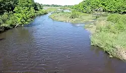
North Fork Ninnescah River
The North Fork Ninnescah River is a river in the central Great Plains of North America. Its entire length lies within the U.S. state of Kansas. It is a tributary of the Ninnescah River.[3]
| North Fork Ninnescah River | |
|---|---|
 North Fork Ninnescah River above Cheney Reservoir | |
| Location | |
| Country | United States |
| State | Kansas |
| Physical characteristics | |
| Source | |
| • location | Stafford County, Kansas |
| • coordinates | 37°50′07″N 98°44′56″W[1] |
| • elevation | 1,942 ft (592 m) |
| Mouth | Ninnescah River |
• location | Sedgwick County, Kansas |
• coordinates | 37°34′05″N 97°42′19″W[1] |
• elevation | 1,302 ft (397 m) |
| Basin size | 930 sq mi (2,400 km2) |
| Discharge | |
| • location | USGS 07144795 at Cheney Dam, KS[2] |
| • average | 119 cu ft/s (3.4 m3/s) |
| • minimum | 0 cu ft/s (0 m3/s) |
| • maximum | 1,910 cu ft/s (54 m3/s) |
| Basin features | |
| Watersheds | North Fork Ninnescah- Ninnescah-Arkansas- Mississippi |
Geography
The North Fork Ninnescah River originates in south-central Kansas in the Arkansas River Lowlands.[3] Its source lies in extreme south-central Stafford County approximately 11.5 miles (18.5 km) south of St. John, Kansas.[1][4] From there, it flows generally northeast before turning to the southeast near Plevna, Kansas. It then flows across a far eastern portion of the High Plains into Cheney Reservoir in the Wellington Lowlands. From the reservoir's dam, the river continues southeast to its confluence with the South Fork Ninnescah River in southwestern Sedgwick County to form the Ninnescah River.[3]
History
In 1965, the U.S. Bureau of Reclamation completed a dam on the river north of Cheney, Kansas for flood control and municipal water supply, creating Cheney Reservoir.[5]
See also
References
- "North Fork Ninnescah River". Geographic Names Information System. United States Geological Survey, United States Department of the Interior. Retrieved 2015-10-19.
- "Water-Data Report 2013 - 07144795 North Fork Ninnescah River at Cheney Dam, KS" (PDF). U.S. Geological Survey. Retrieved 2015-10-19.
- "2003-2004 Official Transportation Map" (PDF). Kansas Department of Transportation. Retrieved 2015-10-19.
- "37.835278,-98.748889". Google Maps. Retrieved 2015-10-19.
- "Wichita Project". U.S. Bureau of Reclamation. Retrieved 2015-10-19.