North Natuna Sea
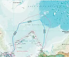
North Natuna Sea[1] (Indonesian: Laut Natuna Utara; Jawi script: لاوت ناتونا اوتارا) is a shallow body of water located north of Natuna Regency. Named by the Indonesian government in July 2017, Indonesia changed the northern part of its Exclusive Economic Zone in the South China Sea to the North Natuna Sea, bordering the southern part of Vietnam's Exclusive Economic Zone.[2][3] The North Natuna Sea lies between the Natuna Islands and the Natuna Sea and Cape Cà Mau south of the Mekong Delta in Vietnam.

| North Natuna Sea | |
|---|---|
| لاوت ناتونا اوتارا (Jawi) | |
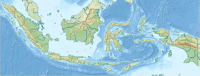
 North Natuna Sea of Riau Islands province. | |
 North Natuna Sea | |
| Coordinates | 5.553°N 108.226°E |
| Type | Sea |
| Native name | لاوت ناتونا اوتارا (Malay) |
| Basin countries | Indonesia |
| Islands | Natuna |
History
The naming of the North Natuna Sea itself has been done by the Malay people who inhabit the Natuna Regency area for a long time.[4] Since the 19th century, the waters of the Natuna Islands have been the territory of the Riau-Lingga Sultanate, which was previously controlled by the Kingdom of Pattani and the Johor Sultanate in Malaysia. Later claims were made by Malaysia based on this history, but these claims were discontinued in line with the Indonesia-Malaysia Confrontation.[5]
In 1982, the United Nations Convention on the Law of the Sea, related to the determination of territorial boundaries and exclusive economic zones, was signed by various parties. The convention confirmed the territorial waters of every country including Indonesia. In "Limits of Oceans and Seas, 4rd edition" (1986) and another revised edition (2000), the International Hydrographic Organisation's recognition of the formation of the Natuna Sea. Therefore, the southern boundary of the South China Sea was moved from the Bangka Belitung Islands to the northern part of the Natuna Islands, but the draft has never been ratified by the International Hydrographic Organisation.[6][7]
Indonesia's exploration of the North Natuna Sea has been conducted since the 1980s, with Exxon Mobil being the first to enter into an agreement regarding the management of oil and gas fields in the area, in the 1990s there was a lot of research and exploration, at the end of the 20th century the company began production. Then in the early 2000s many other companies began to manage the area.[8]
Along with China's increasing claims to the sea area, the Indonesian government began to re-map Indonesia's territory, in 2017, the Indonesian government officially used the name North Natuna Sea as the waters of the Indonesian EEZ area located north of the Natuna Sea.[4]
Geography
The North Natuna Sea is a narrow area of water located within Indonesia's EEZ, to the south of the South China Sea, northeast of the Gulf of Thailand, and north of the Natuna Sea. This sea area intersects with the EEZ boundaries of two ASEAN countries, Vietnam and Malaysia.
This sea is a strategic area because it is an area of international sea traffic originating from East Asia and heading to central and southern Southeast Asia, as well as sea traffic that will pass through the Strait of Malacca. It can be said that this area is a busy sea traffic area. In addition to being a dense sea traffic area, this area is also a central point for the Southeast Asian Region.[4]
Natural resources
The North Natuna Sea area is located at the junction of the deeper sea of the South China Sea and the shallower sea of the Natuna Sea and the Gulf of Thailand. Due to the geographical location and geological activity in this area, the North Natuna Sea region has abundant natural resources.
Biology
The geological formation process of the North Natuna Sea and South China Sea basins over hundreds of millions of years ago has created oil and gas traps under the bottom of the North Natuna Sea and South China Sea. Due to the geological formation of the basin, the North Natuna Sea has a shallow depth, which connects to the deep basin bathymetry of the South China Sea.
The shape of the basin creates a distinctive ocean current circulation pattern, called the Vietnam Jet Current (VJC) and the Natuna Off-Shelf Current (NOC). The Vietnam Jet Current is a high-speed current circulation flowing from the Pacific Ocean west of the South China Sea. The current circulates along the South China Sea cliffs on the northwest/north side passing through Vietnam. It then reverses direction as it approaches the Natuna Sea cliffs (North) so that it is then referred to as the Natuna Off-Shelf Current (NOC).
The Mekong River, which flows off the coast of Vietnam, supplies nutrients from the land to the bottom of the South China Sea. Nutrients from the river are then uplifted by the Vietnam Jet Current and the Natuna Off-Shelf Current. Chlorophyll and oxygen are also evenly and well distributed throughout the coastal waters in the South China Sea and North Natuna Sea due to these ocean currents. So that many marine biota pass by in the area.[9] The North Natuna Sea is the Republic of Indonesia Fisheries Management Area (WPP NRI) 711.[10]
Oil and gas
It is estimated that Natuna's oil and gas reserves are approximately 127 million barrels, with 14,386,470 barrels of oil and 112,356,680 barrels of gas. The area has the potential for hydrocarbon gas which is one of the largest sources in Asia, the potential can be obtained as much as 46 TCT.[11]
The North Natuna Sea area itself has a total of sixteen oil and gas field blocks, but as of 2021 there are eleven oil and gas blocks that have been managed among them:[12][13]
- Block A Natuna Sea
- Block B South Natuna Sea
- Block Cumi-Cumi
- Block Kakap
- Block Northwest Natuna
- Block East Natuna
- Block Northeast Natuna
- Block Nila
- Block South Sokang
- Block Tobong
- Block Tuna
Conflict
Often, the Chinese and Indonesian governments both assert that there is no state of dispute concerning their territorial claims, a stance taken to foster and maintain positive bilateral relations between the two nations.[14][15][16] In 2014, Chinese Foreign Ministry Spokesperson Geng Shuang stated that “There is no territorial dispute between Indonesia and China.”[17] In 2015, Indonesian Minister of Foreign Affairs Retno Marsudi also followed by asserting that "Indonesia does not have overlapping claim with any other countries" and that "no country ever claimed Natuna Islands."[18]
Even so, overlapping the claimed waters of the North Natuna Sea, which is Indonesia's EEZ with China's nine-dash line, China's claim to Indonesian waters is approximately 83,000 km2 or 30 per cent of Indonesia's sea area in Natuna.[19][20][21] This dispute began to surface in 2010, since then there have been frequent conflicts between the Chinese government and the Indonesian government due to the entry of Chinese-flagged vessels, such as fishing boats, research vessels, Chinese coast guard and Chinese warships into part of the North Natuna Sea area, which is a claim from China based on the history of fishing in the previous empire.[22]
Chinese research vessels have been travelling in the North Natuna Sea for some time, but none of their research results have been sent to the Indonesian government.
Fishing conflicts in the North Natuna Sea area are not only from Chinese-flagged fishing boats, but illegal fishing is also often carried out by Vietnamese and Malaysian-flagged fishing boats.[10]
References
- Parameswaran, Prashanth. "Why Did Indonesia Just Rename Its Part of the South China Sea?". thediplomat.com. Retrieved 2021-02-07.
- Tom Allard; Bernadette Christina Munthe (14 July 2017). "Asserting sovereignty, Indonésia renames part of South China Sea". Reuters. Retrieved 1 January 2020.
- "Indonésia Renames Its Portion of the S. China Sea". The Maritime Executive. 14 July 2017. Retrieved 1 January 2020.
- Sambogo, Alief (2018), "Penamaan Laut Natuna Utara oleh Pemerintah Indonesia dalam Prespektif Hukum Internasional" (PDF), Jurist-Diction, Universitas Airlangga, 1 (2), doi:10.20473/jd.v1i2.10787
- Gischa, Serafica (2020-01-04). "Sejarah Konflik Natuna dan Upaya Indonesia". KOMPAS.com (in Indonesian). Retrieved 2023-07-30.
- "Chapter 6: South China and Eastern Archipelagic Seas and It's Subdivision" (PDF). International Hydrographic Organization. 1986. p. 102-105. Archived from the original (PDF) on 2016-03-12. Retrieved 2017-07-19.
- "South China and Eastern Archipelagic Seas and It's Subdivision". International Hydrographic Organisation. 2000. Retrieved 11 January 2022.
- Irfany, Robby (2017-07-19). tnr, Ali Akhmad Noor Hidayat (ed.). "Penjelasan ExxonMobil Mundur dari Konsorsium Gas Natuna". Tempo. Retrieved 2023-07-30.
- Potensi Laut Natuna Utara, Ibarat Taman Bunga Kaya Nektar Bahan Madu, Tribun Batam, retrieved 8 January 2022
- Jay Fajar, Ancaman Berkepanjangan di Laut Natuna Utara, Mongabay.co.id, retrieved 8 January 2022
- Mengenal Natuna, Letak dan Potensi Kekayaan Alamnya, Kompas, retrieved 8 January 2022
- Gambaran Migas Kabupaten Natuna, Pemerintah Kabupaten Natuna, retrieved 8 January 2022
- Khairul Anam, Mengintip Operasi Pengeboran Migas di Laut Natuna Utara: Berlimpah Migas Laut Lepas, Tempo, retrieved 8 January 2022
- "The Next Front: China and Indonesia in the South China Sea - Foreign Policy Research Institute". www.fpri.org. Retrieved 2023-07-30.
- Zou, Yizheng (2023-03-01). "China and Indonesia's responses to maritime disputes in the South China Sea - forming a tacit understanding on security". Marine Policy. 149: 105502. doi:10.1016/j.marpol.2023.105502. ISSN 0308-597X.
- "Foreign Ministry Spokesperson's Remarks". bh.china-embassy.gov.cn. Retrieved 2023-07-30.
- Suryadinata, Leo (2014-04-24). "South China Sea: Is Jakarta no longer neutral?". The Straits Times. ISSN 0585-3923. Retrieved 2023-07-30.
- Humas (2015-11-21). "No Claim from China over Natuna Islands". Sekretariat Kabinet Republik Indonesia. Retrieved 2023-07-30.
- Pereira, Derwin (12 July 2016). "China shouldn't see Jakarta's friendship as sign of weakness". Belfer Center for Science and International Affairs. Retrieved 2023-07-30.
- Sundaryani, Fedina S. (19 July 2016). "Government hopes to expedite East Natuna oil block development". The Jakarta Post. Retrieved 2023-07-30.
- LCS adalah Laut Natuna Utara?, RRI, retrieved 8 January 2022
- Sengketa di Kawasan Laut Natuna Utara, indonesia.go.id, retrieved 8 January 2022