North Stainley
North Stainley is a village in the Harrogate district of North Yorkshire, England 4 miles (6.4 km) north of Ripon.[2] Historically part of the West Riding of Yorkshire, it is the closest settlement to the theme park Lightwater Valley which is 0.62 miles (1 km) to the south.[3]
| North Stainley | |
|---|---|
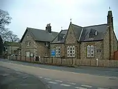
 The Church of England primary school in North Stainley | |
.svg.png.webp) North Stainley Location within North Yorkshire | |
| Population | 737 (2011 Census)[1] |
| OS grid reference | SE286768 |
| Civil parish | |
| District | |
| Shire county | |
| Region | |
| Country | England |
| Sovereign state | United Kingdom |
| Post town | RIPON |
| Postcode district | HG4 |
| Police | North Yorkshire |
| Fire | North Yorkshire |
| Ambulance | Yorkshire |
| UK Parliament | |
History
North Stainley is derived jointly from Old English and Old Norse and means a stone clearing.[4] The village is mentioned in the Domesday Book with 15 ploughlands and belonging to the Archbishop of York.[5] The name of the village derives from the Old English of Stān lēah, which means a stone wood or clearing.[6] North Stainley is on the south bank of the River Ure, and was in the West Riding of Yorkshire until 1974, when it was moved into North Yorkshire. It was formerly in the wapentake of Claro, and the Liberty of Ripon.[7]
The population of the parish in the 2001 census was 604,[8] rising to 737 at the 2011 Census.[1] In 2015, North Yorkshire County Council estimated the population of the parish to be 760. The parish includes the hamlet of Sleningford.[9]
The village is cut through by the A6108 road between Ripon and Leyburn.[10][11] It has a school, North Stainley Church of England Primary School, which is rated as being Requires Improvement by Ofsted[12] and a church, St Mary the Virgin.[13] The church was built in 1840 by the Staveley family, who owned the manor and built the Manor House in the 16th century.[14][15] The pub in the village is called The Staveley Arms.[16]
Since 1983, the parish has been part of the Skipton and Ripon Parliamentary constituency.[17]
References
- UK Census (2011). "Local Area Report – North Stainley with Sleningford Parish Parish (E04007400)". Nomis. Office for National Statistics. Retrieved 4 February 2020.
- "History of North Stainley, in Harrogate and West Riding | Map and description". www.visionofbritain.org.uk. Retrieved 4 February 2020.
- "98" (Map). Northallerton & Ripon. 1:50,000. Landranger. Ordnance Survey. 2016. ISBN 9780319261972.
- Ekwall, Eilert (1960). The concise Oxford dictionary of English place-names (4 ed.). Oxford: Oxford University Press. p. 436. OCLC 400936.
- "[North] Stainley | Domesday Book". opendomesday.org. Retrieved 4 February 2020.
- Ekwall, Eilert (1960). The concise Oxford dictionary of English place-names (4 ed.). Oxford: Oxford University Press. p. 436. ISBN 0-19-869103-3.
- "Genuki: In 1822, the following places were in the Parish of Ripon:, Yorkshire (West Riding)". www.genuki.org.uk. Retrieved 4 February 2020.
- UK Census (2001). "Local Area Report – North Stainley with Sleningford Parish (36UD099)". Nomis. Office for National Statistics. Retrieved 4 February 2020.
- "2015 Population Estimates Parishes" (PDF). northyorks.gov.uk. December 2016. p. 13. Archived from the original (PDF) on 4 June 2022. Retrieved 4 February 2020.
- "Quarry chiefs want extra 98 acres". The Yorkshire Post. 13 October 2009. Retrieved 4 February 2020.
- "299" (Map). Ripon & Boroughbridge. 1:25,000. Explorer. Ordnance Survey. 2015. ISBN 9780319245514.
- "North Stainley Church of England Primary School URN: 121578". November 2022. Retrieved 28 March 2023.
- "North Stainley St Mary the Virgin". explorechurches.org. Retrieved 4 February 2020.
- Pevsner, Nikolaus (2001). Yorkshire : the West Riding (2 ed.). London: Penguin Books. p. 380. ISBN 0-14-071017-5.
- Dale, Sharon (16 January 2012). "Hall or nothing for Robert". The Yorkshire Post. Retrieved 4 February 2020.
- Aird, Alisdair; Stapley, Fiona, eds. (2014). The good pub guide 2015. London: Random House. p. 921. ISBN 9780091958084.
- "History of North Stainley, in Harrogate and West Riding | Historical administrative units and statistics". www.visionofbritain.org.uk. Retrieved 4 February 2020.