Jesús (Ibiza)
Nostra Senyora de Jesús is a village on the northern side of Ibiza Bay,[1] a Spanish island of Ibiza, Spain. The village is in the municipality of Santa Eulària des Riu and is located on the designated road PMV 810.[2] The village is 2.0 miles (3.2 km) North of Ibiza Town and 6.7 miles (10.8 km) of Ibiza Airport.
Jesús | |
|---|---|
Village | |
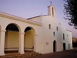
 The Parish Church | |
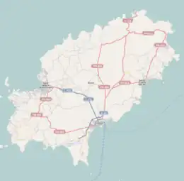
 Jesús Location of the village in Ibiza | |
| Coordinates: 38°55′51″N 1°26′58″E | |
| Country | |
| Region | Balearic Islands |
| Population (2006) | |
| • Total | 4,499 |
| Time zone | UTC+1 (CET) |
| • Summer (DST) | UTC+2 (CEST) |
Description
The village of Jesús is a short distance along the road to Cala Llonga from Ibiza town. It is now more of a suburb[3] of Ibiza town than a village, offering a wide range of restaurants and small shops. There are also several beaches in the vicinity of the village, such as Platja S'Estanyol and Talamanca.
The Can Pep Simó Estate
On the hillside above the village are two important housing developments. The Can Pep Simó estate, designed in the 1970s by Catalan architects Erwin Broner and Josep Lluís Sert. The developments are described as a combination of traditional and modern architecture and attract students of architecture from across the globe.
The Church of Nostra Mare de Jesús
At the heart of the village is the white washed parish church of Nostra Mare de Jesús which is considered to be the oldest church on the island. Despite the ever expanding sprawl of Ibiza town, there is still an open vista of the green fields and orchards towards the prominent hill of Dalt Vila. It is thought that Franciscan friars established the site in 1498.[4] After fifty years, the Franciscans left the site to the Dominican order, who eventually moved to the better protected Dalt Vila due to pirate raids. In 1755,[4] the old monastic building was turned into a parish church. What distinguished this church from others on the island is its altarpiece painted around 1500 by Rodrigo de Osona.[4] The altarpiece has 25 painted panels, with the central panel having a representation of the Virgin and child. The surrounding panels have images of saints and themes such as the Annunciation, the Nativity of Jesus, the Resurrection, and the Ascension.
References
- Mapa Topografico Nacional de Espana, 798 Eivissa. 1:50.000. Published: IGN - CNIG (Spain Civilian Survey): 2006.
- "579 Regional Map, Spain, Islas Baleares. Pub:Michelin Editions des Voyages, 2004, ISBN 2-06-710098-X
- The Rough Guide to Ibiza & Formentera. Pub:Rough Guides, Penguin Group, 2003, ISBN 1-84353-063-5
- Ibiza & Formentera’s Heritage, A Non-clubber’s Guide. Author: Paul R Davis Pub:Barbary Press, 2009, ISBN 978-84-612-2908-6