Nottoway River
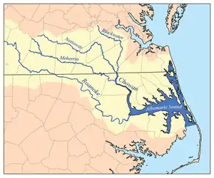
The Nottoway River is a river in the U.S. State of Virginia and northeastern North Carolina that is 155 miles (249 kilometers) in length. The river begins in Prince Edward County and merges with the Blackwater River to form the Chowan River in North Carolina. The river is part of the Chowan River system, which empties into the Albemarle Sound in North Carolina.
| Nottoway River | |
|---|---|
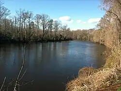
 Nottoway River in Courtland, Virginia | |
 | |
| Location | |
| Country | United States |
| State | Virginia, North Carolina |
| Physical characteristics | |
| Source | |
| • location | Boundary between Prince Edward and Lunenberg Counties |
| • coordinates | 37°06′22″N 078°19′18″W[1] |
| Mouth | Chowan River |
• location | Confluence with the Blackwater River to form the Chowan River |
• coordinates | 36°32′38″N 076°54′58″W[1] |
| Length | 155 miles[2] |
| Basin size | 1.1 million acres[2] |
| Basin features | |
| Progression | southeast |
| River system | Chowan River |
Course
The Nottoway River rises in a dense forest outside of Scholfield, an unincorporated community in Prince Edward County. The Nottoway serves as the boundary of Prince Edward and Lunenburg counties, then Nottoway and Lunenburg counties. The river serves as the boundaries for many counties such as Brunswick, Dinwiddie, Sussex, where it makes a northeastern jump, and Greensville County. The river then courses southeast into Southampton County. The Nottoway River reaches North Carolina 9.53 miles (15.34 km) south of Franklin, Virginia. The river only briefly enters North Carolina for a mere 1,455 feet (443 meters) where the river ends at the confluence of the Blackwater & Nottoway Rivers, creating the Chowan River in Hertford County, North Carolina.
Fishing
The Nottoway River is known for its abundance of bass, catfish, and bluegill, along with the river's multiple boat ramps across multiple counties.[3]
Cities and towns
Cities and towns along the river include:
External links
References
- "GNIS Detail - Nottoway River". geonames.usgs.gov. US Geological Survey. Retrieved 31 May 2019.
- "Nottoway River". www.a-cwrt.org. Ablemarle-Chowan Watershed Roundtable. Retrieved 31 May 2019.
- "Nottoway River | Virginia DWR". Retrieved 2020-08-27.