Nukutula
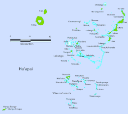
Nukutula is an island in the Haʻapai Archipelago, belonging to the Kingdom of Tonga.[1][2] Among neighboring islands are Telekitonga, Kelefesia, Nomuka, Tonumea, Fonoifua.[3]
 Kelefesia is the southernmost island | |
| Geography | |
|---|---|
| Location | South Pacific |
| Coordinates | 20.251°S 174.689°W |
| Archipelago | Haʻapai, Nomuka island group |
| Highest elevation | 5 m (16 ft) |
| Administration | |
| Division | Haʻapai |
Geography
Nukutula is a wooded sand cay, 18 feet high, lying on a reef about 2 miles northward of Nukufaiau.[4][5] The island lies in the center of ʻOtu Muʻomuʻa along with Nukufaiau. To the east are the islands of Fonoifua, Tanoa, and Meama with the reefs of Mai Reef and Lua Anga, and to the west is the main island of Nomuka.
Climate
The climate is tropical, but moderated by constantly blowing winds. Like the other islands in the Ha'apai group, Nukutula is occasionally hit by cyclones.
References
- Fiji, Tonga, and Nauru: Official Standard Names Approved by the United States Board on Geographic Names. U.S. Board on Geographic Names. 1974. p. 222. Retrieved 6 July 2023.
- "Nukutula island". geonames.org. Retrieved 6 July 2023.
- Department, Great Britain Hydrographic (1943). Pacific Islands Pilot: Vol. II. The Central Groups Comprising New Caledonia and Iles Loyalty; the New Hebrides Group and Santa Cruz Islands; the Fiji Islands and the Tonga, Samoa, Ellice, Gilbert, Marshall, Phoenix and Tokelau Islands. Hydrographic Department, Admiralty. p. 372. Retrieved 6 July 2023.
- Publications. U.S. Government Printing Office. 1961. p. 136. Retrieved 6 July 2023.
- Pacific Islands Pilot: Vol. II. The Central Groups Comprising New Caledonia and Iles Loyalty; the New Hebrides Group and Santa Cruz Islands; the Fiji Islands and the Tonga, Samoa, Ellice, Gilbert, Marshall, Phoenix and Tokelau Islands. Hydrographic Department, Admiralty. 1943. p. 374. Retrieved 6 July 2023.
This article is issued from Wikipedia. The text is licensed under Creative Commons - Attribution - Sharealike. Additional terms may apply for the media files.