Kat O
Kat O (Chinese: 吉澳) also named Crooked Island, is an island in Northeast Hong Kong.
吉澳 | |
|---|---|
.jpg.webp) The pier of Kat O | |
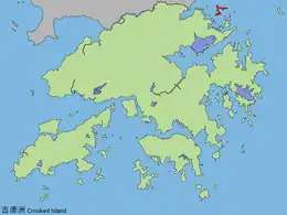 Location of Kat O in Hong Kong | |
| Geography | |
| Location | North District |
| Area | 2.35 km2 (0.91 sq mi) |
| Highest elevation | 122 m (400 ft) |
| Highest point | Kai Kung Leng (雞公嶺) |
| Administration | |
| Kat O | |||||||||||||
|---|---|---|---|---|---|---|---|---|---|---|---|---|---|
| Traditional Chinese | 吉澳 | ||||||||||||
| Literal meaning | Crooked Island | ||||||||||||
| |||||||||||||

Administration
Administratively, Kat O is part of North District. It is a recognized village under the New Territories Small House Policy.[1]
Geography

Kat O is located in the west of Mirs Bay.[2] With an area of 2.35 km²,[3] it is the largest island in North District, the second largest being Wong Wan Chau (Double Island).[4] Neighbouring islands include: Ap Chau, Ngo Mei Chau (Crescent Island), and Pak Sha Chau (Round Island). The village of Tung O (東澳) is located on its northwest coast.[4] Its highest point is Kai Kung Leng (雞公嶺), which is 122 m above sea level.[2]
O Pui Tong (澳背塘) is a bay surrounded by the crook-shaped Crooked Island and Yeung Chau.[5] O Pui Tong, together with the northwestern waters of Kat O, are two of the 26 designated marine fish culture zones in Hong Kong.[6]
History
Kat O was once a major fishing market in Hong Kong,[7] and long served as an important stopover for boats travelling between Hong Kong and the rest of China.[8]
During the Ming dynasty, a decree required all inhabitants to leave the island. Then in the 1660s, soon after the end of the dynasty, it was re-settled by Hakka people.[8] Other residents were Tanka fishermen.[7]
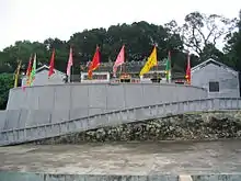
The Tin Hau Temple at Kat O was estimated to be built in 1763.[9] It is listed as a Grade III historic building.[10] Part of the temple building was used for the Tat O School until the school was moved to a new location in 1957.[7] A Pak Kung Shrine is also located in the vicinity.[11]
The island is home to three cannons. These are thought to have been made in the west, during the 19th century.[11]
Conservation
Kat O was part of the Plover Cove (Extension) Country Park since 1979.[12]
The Kat O Nature Trail spans 1 km long, stretching from the Kat O Ferry Pier to Ko Tei Teng (高地頂).[2]
The Kat O Geoheritage Centre (at No. 142 Kat O Main Street) was opened in 2010[13] by Kat O villagers, volunteer groups and the government to raise public awareness of geo-conservation, as part of the Hong Kong Geopark.[14]
References
- "List of Recognized Villages under the New Territories Small House Policy" (PDF). Lands Department. September 2009.
- Hong Kong Geopark: Kat O Nature Trail
- Survey and Mapping Office, Lands Department: Hong Kong geographic data sheet
- K.W. Lai, S.D.G. Campbell & R. Shaw, Geology of the Northeastern New Territories, p. 15, Civil Engineering Dept, Geotechnical Engineering Office, December 1996
- "O Pui Tong Fish Culture Zone". Project WATERMAN. The University of Hong Kong.
- "Marine fish culture, pond fish culture and oyster culture". Fisheries Branch. Agriculture, Fisheries and Conservation Department. 12 August 2019. Retrieved 16 December 2019.
- Antiquities Advisory Board. Historic Building Appraisal. Tin Hau Temple, Sai O, Kat O
- HKFP Venture: Kat O, Hong Kong’s forgotten island – once its international gateway, HKFP, by Rhoda Kwan. 6 Sept 2020
- Welcome to 18 Districts - North District
- Antiquities Advisory Board. List of the 1,444 Historic Buildings with Assessment Results
- "Crooked Island". 2016-03-04. Archived from the original on 2016-03-04. Retrieved 2019-05-10.
- Agriculture, Fisheries and Conservation Department: Plover Cove Country Park Archived 2013-09-29 at the Wayback Machine
- Time Out Hong Kong: "Secret Hong Kong islands", 29 Apr 2014
- Hong Kong Geopark: Kat O Geoheritage Centre
Further reading
- Choi, C.C. (1990). "Studies on Hong Kong Jiao Festivals" (PDF). Journal of the Royal Asiatic Society Hong Kong Branch. 30: 26–43. ISSN 1991-7295.
External links
- Delineation of area of existing village Kat O (Sha Tau Kok) for election of resident representative (2019 to 2022)
- Kut-O Chinese Association (Kent area) Website
- Pictures of Kat O: ,
- Hong Kong Geopark: "Lee Yuk Ying Introduces the Cultural History of Kat O to Visitors".
- Webpage about Kat O
- Antiquities Advisory Board. Pictures of Tin Hau Temple, Sai O, Kat O
- How to visit two of Hong Kong's most remote islands in one day CNN.com