Oberhalbstein Alps
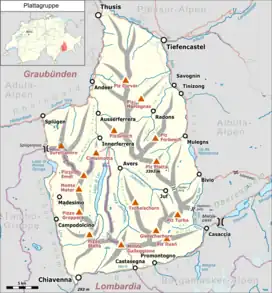
The Oberhalbstein Alps (German: Oberhalbsteiner Alpen) or Platta Group (Italian: Alpi del Platta) are a mountain range in the Alps of eastern Switzerland and northern Italy. They are considered to be part of the Central Eastern Alps. The Oberhalbstein Alps are separated from the Lepontine Alps in the west by the Splügen Pass; from the Plessur Alps in the north by the river Albula; from the Albula Alps in the east by the Septimer Pass and the river Gelgia; from the Bernina Range in the south by the Val Bregaglia.
| Oberhalbstein Alps | |
|---|---|
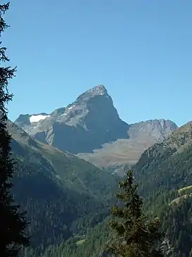 Piz Platta | |
| Highest point | |
| Peak | Piz Platta |
| Elevation | 3,386 m (11,109 ft) |
| Coordinates | 46°29′13.1″N 9°33′42.2″E |
| Geography | |
 Oberhalbstein Alps
The borders of the range according to Alpine Club classification of the Eastern Alps | |
| Countries | Switzerland and Italy |
| States | Graubünden and Lombardy |
| Range coordinates | 46°27.3′N 9°30.45′E |
| Parent range | Central Eastern Alps |
The Oberhalbstein Alps are drained by the rivers Hinterrhein, Gelgia, Liro and Mera.
Peaks
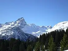
Piz Platta
The main peaks of the Oberhalbstein Alps are:
| Peak | Elevation | |
|---|---|---|
| m | ft | |
| Piz Platta | 3392 | 11,129 |
| Piz Forbesch | 3258 | 10,689 |
| Piz Timun | 3201 | 10,502 |
| Pizzo Stella | 3163 | 10,375 |
| Piz Duan | 3133 | 10,279 |
| Pizz Gallagiun | 3107 | 10,200 |
| Gletscherhorn | 3106 | 10,191 |
| Cima da Lägh | 3082 | 10,112 |
| Piz Grisch | 3062 | 10,050 |
| Usser Wissberg | 3053 | 10,016 |
| Piz Bles | 3045 | 9,990 |
| Surettahorn | 3027 | 9,971 |
| Tscheischhorn | 3019 | 9,905 |
| Piz Curvér | 2975 | 9,761 |
| Piz Alv | 2854 | 9,365 |
| Piz Miez | 2835 | 9,301 |
| Sur Carungas | 2829 | 9,281 |
| Piz Mez | 2718 | 8,917 |
| Piz Arlos | 2696 | 8,847 |
Passes
The main mountain passes of the Oberhalbstein Alps are:
| Mountain pass | location | type | elevation | |
|---|---|---|---|---|
| m | ft | |||
| Passo della Duana | Avers to the Val Bregaglia | snow | 2800 | 9187 |
| Passo da la Prasignola | Avers to Soglio | cattle path | 2720 | 8924 |
| Forcella di Lago or Madris Pass | Avers to Chiavenna | footpath | 2680 | 8793 |
| Forcellina | Avers to the Septimer Pass | footpath | 2673 | 8770 |
| Passo di Lei | Avers to Chiavenna | footpath | 2659 | 8724 |
| Stallerberg | Avers to Bivio | footpath | 2584 | 8478 |
| Pass da Sett (Septimer Pass) | Bivio to Val Bregaglia | bridle path | 2311 | 7582 |
| Pass da Niemet | Innerferrera to Madesimo | footpath | 2280 | 7481 |
References
- Swisstopo maps
This article is issued from Wikipedia. The text is licensed under Creative Commons - Attribution - Sharealike. Additional terms may apply for the media files.
