Ohio State Route 139
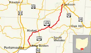
State Route 139 (SR 139) is a north–south road that stretches from New Boston at its southern terminus to Jackson, Ohio at its northern terminus. This route offers a quick, yet narrow and sharp route to Jackson. US 23 and SR 32 offer a more straight route with a higher speed limit, though less direct.
State Route 139 | ||||
|---|---|---|---|---|
 | ||||
| Route information | ||||
| Maintained by ODOT | ||||
| Length | 33.99 mi[1] (54.70 km) | |||
| Existed | 1924–present | |||
| Major junctions | ||||
| South end | ||||
| North end | ||||
| Location | ||||
| Country | United States | |||
| State | Ohio | |||
| Counties | Scioto, Jackson | |||
| Highway system | ||||
| ||||
| ||||
SR 139 begins at an intersection with US 52 in New Boston. The route goes north through a couple of traffic lights before passing through Portsmouth, Eden Park, Twin Valley, Rubyville, and Clarktown before it continues due east toward Minford. From there it crosses SR 335 and then begins to turn north once again. After reaching the Scioto County and Jackson County line, SR 279 splits off of State Route 139 and heads toward Oak Hill. SR 139 crosses SR 32 just outside Jackson and SR 776 within less than mile of downtown. The route then briefly overlaps SR 93 in downtown Jackson, terminating 0.15 miles (0.24 km) north where State Route 93 turns east.
History
SR 139 was first designated in 1923 along the New Boston–Jackson route it has always followed.[2] SR 139 fully replaced SR 402 which had been in existence since the creation of the state highway system in 1912.[3][4] No major changes have occurred to SR 139's routing since it was first designated.
Major intersections
| County | Location | mi[1] | km | Destinations | Notes |
|---|---|---|---|---|---|
| Scioto | New Boston | 0.00 | 0.00 | ||
| 0.11 | 0.18 | ||||
| Madison Township | 10.91 | 17.56 | |||
| Jackson | Hamilton Township | 18.92 | 30.45 | Western terminus of SR 279 | |
| Madison Township | 30.65 | 49.33 | |||
| Jackson | 33.35 | 53.67 | Eastern terminus of SR 776 | ||
| 33.74 | 54.30 | Southern end of SR 93 concurrency | |||
| 33.99 | 54.70 | Northern end of SR 93 concurrency | |||
1.000 mi = 1.609 km; 1.000 km = 0.621 mi
| |||||
References
- Ohio Department of Transportation. "Technical Services Straight Line Diagrams". Retrieved April 30, 2010.
- Map of Ohio Showing State Routes (MrSID) (Map). Cartography by L.A. Boulay, Director. Ohio Division of Highways. 1923. Retrieved August 18, 2013.
- Map of Ohio Showing Inter-County Highways (MrSID) (Map). Cartography by James R. Marker, State Highway Commissioner. Ohio State Highway Department. 1912. Retrieved August 18, 2013.
- Map of Ohio State Highways Showing All Improved Roadways (MrSID) (Map). Cartography by E.C. Blosser. ODOH. 1922. Retrieved August 18, 2013.

