Ohio State Route 348
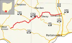
State Route 348 (SR 348) is an east–west state highway in the south central portion of the U.S. state of Ohio. Its western terminus is at State Route 125 approximately 6 miles (9.7 km) east of West Union, and its eastern terminus is at U.S. Route 23 just north of Lucasville – this is also the western terminus of State Route 728.
State Route 348 | ||||
|---|---|---|---|---|
 | ||||
| Route information | ||||
| Maintained by ODOT | ||||
| Length | 32.24 mi[1] (51.89 km) | |||
| Existed | 1935–present | |||
| Major junctions | ||||
| West end | ||||
| East end | ||||
| Location | ||||
| Country | United States | |||
| State | Ohio | |||
| Counties | Adams, Scioto | |||
| Highway system | ||||
| ||||
| ||||
History
SR 348 was commissioned in 1935, routed on its current route, with the eastern terminus at its intersection with SR 73 in Otway.[2][3] In 1939 the route was extended east to U.S. Route 23, near Lucasville.[4][5] A section of SR 348 from Otway to Lucasville was originally designated a part of Corridor B on the Appalachian Development Highway System. Only a section from U.S. Route 23 to west of SR 104 was ever completed.[6][7][8]
Major intersections
| County | Location | mi[1] | km | Destinations | Notes |
|---|---|---|---|---|---|
| Adams | Tiffin Township | 0.00 | 0.00 | ||
| Jefferson Township | 12.80 | 20.60 | Eastern terminus of SR 781 | ||
| Scioto | Otway | 19.78 | 31.83 | Southern end of SR 73 concurrency | |
| 19.93 | 32.07 | Northern end of SR 73 concurrency | |||
| Morgan Township | 30.97 | 49.84 | |||
| Valley Township | 32.24 | 51.89 | Western terminus of SR 728 | ||
1.000 mi = 1.609 km; 1.000 km = 0.621 mi
| |||||
References
- Ohio Department of Transportation. "Technical Services Straight Line Diagrams". Retrieved 2010-04-30.
- Ohio Department of Highways (1934). Map of Ohio Showing State Highway System (PDF) (Map). 1:760,320. Columbus: Ohio Department of Highways. OCLC 5673562, 7236991. Retrieved October 23, 2013.
- Ohio Department of Highways (1935). Official Highway Map of Ohio (PDF) (Map). [1:760,320]. Columbus: Ohio Department of Highways. OCLC 5673562, 54667348. Retrieved October 23, 2013.
- Ohio Department of Highways (1938). Ohio Official Highway Map (PDF) (Map). 1:633,600. Columbus: Ohio Department of Highways. OCLC 5673562, 7453129. Retrieved October 23, 2013.
- Ohio Department of Highways (1939). Ohio Highway Map (PDF) (Map). 1:633,600. Columbus: Ohio Department of Highways. OCLC 5673562, 7408341. Retrieved October 23, 2013.
- "Appalachian Highway Jobs Skid to Screeching Halt". The Press-Gazette. February 16, 1973. p. 4. Retrieved December 15, 2018 – via https://www.newspapers.com/.
{{cite news}}: External link in|via= - "State Denies Blocking Of Appalachian Road Network". Hillsboro Press Gazette. October 16, 1974. p. 1. Retrieved December 15, 2018 – via https://www.newspapers.com/.
{{cite news}}: External link in|via= - "Hearing Set For Highway Project". Hillsboro Press Gazette. June 24, 1977. p. 1. Retrieved December 15, 2018 – via https://www.newspapers.com/.
{{cite news}}: External link in|via=
