Ohio statistical areas

The U.S. State of Ohio currently has 57 statistical areas that have been delineated by the Office of Management and Budget (OMB). On March 6, 2020, the OMB delineated 11 combined statistical areas, 14 metropolitan statistical areas, and 32 micropolitan statistical areas in Ohio.[1]
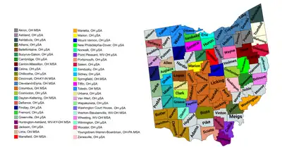
Map of the 46 core-based statistical areas in Ohio.
An enlargeable map of the 46 core-based statistical areas in Ohio.[1]

Statistical areas

The Office of Management and Budget (OMB) has designated more than 1,000 statistical areas for the United States and Puerto Rico.[2] These statistical areas are important geographic delineations of population clusters used by the OMB, the United States Census Bureau, planning organizations, and federal, state, and local government entities.

The OMB defines a core-based statistical area (commonly referred to as a CBSA) as "a statistical geographic entity consisting of the county or counties (or county-equivalents) associated with at least one core[lower-alpha 1] of at least 10,000 population, plus adjacent counties having a high degree of social and economic integration with the core as measured through commuting ties with the counties containing the core."[2] The OMB further divides core-based statistical areas into metropolitan statistical areas (MSAs) that have "a population of at least 50,000" and micropolitan statistical areas (μSAs) that have "a population of at least 10,000, but less than 50,000."[2]

The OMB defines a combined statistical area (CSA) as "a geographic entity consisting of two or more adjacent core-based statistical areas with employment interchange measures[lower-alpha 2] of at least 15%."[2] The primary statistical areas (PSAs) include all combined statistical areas and any core-based statistical area that is not a constituent of a combined statistical area.

Table

The table below describes the 57 United States statistical areas and 88 counties of the State of Ohio with the following information:[3]

  1. The combined statistical area (CSA) as designated by the OMB.[1]
  2. The CSA population according to 2019 US Census Bureau population estimates.[4]
  3. The core-based statistical area (CBSA)[2] as designated by the OMB.[1]
  4. The CBSA population according to 2019 US Census Bureau population estimates [4]
  5. The county name
  6. The county population according to 2019 US Census Bureau population estimates [4]
The 57 United States statistical areas and 88 counties of the State of Ohio

Combined statistical area 2019 population Core-based statistical area 2019 population County 2019 population
Cleveland–Akron–Canton, OH CSA 3,586,918 Cleveland–Elyria, OH MSA 2,048,449 Cuyahoga County, Ohio 1,235,072
Lorain County, Ohio 309,833
Lake County, Ohio 230,149
Medina County, Ohio 179,746
Geauga County, Ohio 93,649
Akron, OH MSA 703,479 Summit County, Ohio 541,013
Portage County, Ohio 162,446
Canton–Massillon, OH MSA 397,520 Stark County, Ohio 370,606
Carroll County, Ohio 26,914
Wooster, OH μSA 115,710 Wayne County, Ohio 115,710
Ashtabula, OH μSA 97,241 Ashtabula County, Ohio 97,241
New Philadelphia-Dover, OH μSA 91,987 Tuscarawas County, Ohio 91,987
Sandusky, OH μSA 74,266 Erie County, Ohio 74,266
Norwalk, OH μSA 58,266 Huron County, Ohio 58,266
Columbus–Marion–Zanesville, OH CSA 2,525,639 Columbus, OH MSA 2,122,271 Franklin County, Ohio 1,316,756
Delaware County, Ohio 209,177
Licking County, Ohio 176,862
Fairfield County, Ohio 157,574
Union County, Ohio 58,988
Pickaway County, Ohio 58,457
Madison County, Ohio 44,731
Perry County, Ohio 36,134
Morrow County, Ohio 35,328
Hocking County, Ohio 28,264
Zanesville, OH μSA 86,215 Muskingum County, Ohio 86,215
Chillicothe, OH μSA 76,666 Ross County, Ohio 76,666
Marion, OH μSA 65,093 Marion County, Ohio 65,093
Mount Vernon, OH μSA 62,322 Knox County, Ohio 62,322
Bellefontaine, OH μSA 45,672 Logan County, Ohio 45,672
Cambridge, OH μSA 38,875 Guernsey County, Ohio 38,875
Washington Court House, OH μSA 28,525 Fayette County, Ohio 28,525
Cincinnati–Wilmington–Maysville, OH–KY–IN CSA 2,280,246
1,727,037
Cincinnati, OH-KY-IN MSA 2,221,208
1,685,069
Hamilton County, Ohio 817,473
Butler County, Ohio 383,134
Warren County, Ohio 234,602
Clermont County, Ohio 206,428
Kenton County, Kentucky 166,998
Boone County, Kentucky 133,581
Campbell County, Kentucky 93,584
Dearborn County, Indiana 49,458
Brown County, Ohio 43,432
Grant County, Kentucky 25,069
Franklin County, Indiana 22,758
Pendleton County, Kentucky 14,590
Gallatin County, Kentucky 8,869
Bracken County, Kentucky 8,303
Union County, Indiana 7,054
Ohio County, Indiana 5,875
Wilmington, OH μSA 41,968 Clinton County, Ohio 41,968
Maysville, KY μSA 17,070 Mason County, Kentucky 17,070
Dayton–Springfield–Kettering, OH CSA 1,080,282 Dayton, OH MSA 807,611 Montgomery County, Ohio 531,687
Greene County, Ohio 168,937
Miami County, Ohio 106,987
Springfield, OH MSA 134,083 Clark County, Ohio 134,083
Greenville, OH μSA 51,113 Darke County, Ohio 51,113
Sidney, OH μSA 48,590 Shelby County, Ohio 48,590
Urbana, OH μSA 38,885 Champaign County, Ohio 38,885
Toledo–Findlay-Tiffin, OH CSA 831,295 Toledo, OH MSA 641,816 Lucas County, Ohio 428,348
Wood County, Ohio 130,817
Fulton County, Ohio 42,126
Ottawa County, Ohio 40,525
Findlay, OH μSA 75,783 Hancock County, Ohio 75,783
Fremont, OH μSA 58,518 Sandusky County, Ohio 58,518
Tiffin, OH μSA 55,178 Seneca County, Ohio 55,178
Youngstown–Warren, OH–PA CSA 637,964
528,540
Youngstown–Warren–Boardman, OH–PA MSA 536,081
426,657
Mahoning County, Ohio 228,683
Trumbull County, Ohio 197,974
Mercer County, Pennsylvania 109,424
Salem, OH μSA 101,883 Columbiana County, Ohio 101,883
Lima–Van Wert–Celina, OH CSA 217,454 Lima, OH MSA 102,351 Allen County, Ohio 102,351
Wapakoneta, OH μSA 46,699 Auglaize County, Ohio 45,656
Celina, OH μSA 41,172 Mercer County, Ohio 41,172
Van Wert, OH μSA 28,275 Van Wert County, Ohio 28,275
Mansfield–Ashland–Bucyrus, OH CSA 216,132 Mansfield, OH MSA 121,154 Richland County, Ohio 121,154
Ashland, OH μSA 53,484 Ashland County, Ohio 53,484
Bucyrus-Galion, OH μSA 41,494 Crawford County, Ohio 41,494
Charleston-Huntington-Ashland, WV-OH-KY CSA 776,694
164,675
Huntington-Ashland, WV-OH-KY MSA 355,873
59,463
Cabell County, West Virginia 91,945
Lawrence County, Ohio 59,463
Putnam County, West Virginia 56,450
Boyd County, Kentucky 46,718
Wayne County, West Virginia 39,402
Greenup County, Kentucky 35,098
Carter County, Kentucky 26,797
Charleston, WV MSA 257,074 Kanawha County, West Virginia 178,124
Jackson County, West Virginia 28,576
Boone County, West Virginia 21,457
Lincoln County, West Virginia 20,409
Clay County, West Virginia 8,508
Portsmouth, OH μSA 75,314 Scioto County, Ohio 75,314
Point Pleasant, WV-OH μSA 56,414
29,898
Gallia County, Ohio 29,898
Mason County, West Virginia 26,516
Mount Gay-Shamrock, WV μSA 32,019 Logan County, West Virginia 32,019
none Wheeling, WV-OH MSA 138,948
67,006
Belmont County, Ohio 67,006
Ohio County, West Virginia 41,411
Marshall County, West Virginia 30,531
Athens, OH μSA 65,327 Athens County, Ohio 65,327
Pittsburgh-New Castle-Weirton PA-OH-WV CSA 2,603,259
65,325
Pittsburgh, PA MSA 2,317,600 Alleghany County, Pennsylvania 1,216,045
Westmoreland County, Pennsylvania 348,899
Washington County, Pennsylvania 206,865
Butler County, Pennsylvania 187,853
Beaver County, Pennsylvania 163,929
Fayette County, Pennsylvania 129,274
Armstrong County, Pennsylvania 64,735
Weirton-Steubenville, WV-OH MSA 116,074
65,325
Jefferson County, Ohio 65,325
Hancock County, West Virginia 28,810
Brooke County, West Virginia 21,939
New Castle, PA μSA 85,512 Lawrence County, Pennsylvania 88,512
Indiana, PA μSA 84,073 Indiana County, Pennsylvania 84,073
Parkersburg-Marietta-Vienna, WV-OH CSA 149,250
59,911
Parkersburg-Vienna, WV MSA 89,339 Wood County, West Virginia 83,518
Wirt County, West Virginia 5,821
Marietta, OH μSA 59,911 Washington County, Ohio 59,911
none Defiance, OH μSA 38,087 Defiance County, Ohio 38,087
Coshocton, OH μSA 36,600 Coshocton County, Ohio 36,600
Jackson, OH μSA 32,413 Jackson County, Ohio 32,413
none Holmes County, Ohio 43,960
Highland County, Ohio 43,161
Preble County, Ohio 40,882
Williams County, Ohio 36,692
Putnam County, Ohio 33,861
Hardin County, Ohio 31,365
Pike County, Ohio 27,772
Adams County, Ohio 27,698
Henry County, Ohio 27,006
Meigs County, Ohio 22,907
Wyandot County, Ohio 21,772
Paulding County, Ohio 18,672
Harrison County, Ohio 15,040
Morgan County, Ohio 14,508
Noble County, Ohio 14,424
Monroe County, Ohio 13,654
Vinton County, Ohio 13,085
State of Ohio 11,623,775

See also

Notes

  1. The OMB defines a core as "a densely settled concentration of population, comprising an Urban Area (of 10,000 or more population) delineated by the Census Bureau, around which a core-based statistical area is delineated."[2]
  2. The OMB defines the employment interchange measure as "the sum of the percentage of workers living in the smaller entity who work in the larger entity plus the percentage of employment in the smaller entity that is accounted for by workers who reside in the larger entity."[2]

References

  1. Revised Delineations of Metropolitan Statistical Areas, Micropolitan Statistical Areas, and Combined Statistical Areas, and Guidance on Uses of the Delineations of These Areas (March 6, 2020). "0MB BULLETIN NO. 20-01" (PDF). Office of Management and Budget. Retrieved December 15, 2021.{{cite web}}: CS1 maint: multiple names: authors list (link)
  2. "2020 Standards for Delineating Core Based Statistical Areas". Office of Management and Budget. July 16, 2021. Retrieved December 15, 2021.
  3. An out-of-state area and its population are displayed in green. An area that extends into more than one state is displayed in teal. A teal population number over a black population number show the total population versus the in-state population.
  4. "Annual Estimates of the Resident Population for Counties in the United States: April 1, 2010 to July 1, 2019". United States Census Bureau, Population Division. April 2020. Archived from the original on March 27, 2020. Retrieved April 9, 2020.

40.2862°N 82.7937°W / 40.2862; -82.7937 (State of Ohio)

This article is issued from Wikipedia. The text is licensed under Creative Commons - Attribution - Sharealike. Additional terms may apply for the media files.