Okta
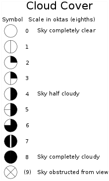
In meteorology, an okta is a unit of measurement used to describe the amount of cloud cover at any given location such as a weather station. Sky conditions are estimated in terms of how many eighths of the sky are covered in cloud, ranging from 0 oktas (completely clear sky) through to 8 oktas (completely overcast). In addition, in the SYNOP code there is an extra cloud cover indicator '9' indicating that the sky is totally obscured (i.e. hidden from view), usually due to dense fog or heavy snow.[1]

When used in weather charts, okta measurements are shown by means of graphic symbols (rather than numerals) contained within weather circles, to which are attached further symbols indicating other measured data such as wind speed and wind direction.[2]
Although relatively straightforward to measure (visually, for instance, by using a mirror[3]), oktas only estimate cloud cover in terms of the area of the sky covered by clouds. They do not account for cloud type or thickness, and this limits their use for estimating cloud albedo or surface solar radiation receipt.
Cloud oktas can also be measured using satellite imagery from geostationary satellites equipped with high-resolution image sensors such as Himawari-8. Similar to traditional approaches, satellite images do not account for cloud composition.
Oktas are often referenced in aviation weather forecasts and low level forecasts: SKC = Sky clear (0 oktas); FEW = Few (1 to 2 oktas); SCT = Scattered (3 to 4 oktas); BKN = Broken (5 to 7 oktas); OVC = Overcast (8 oktas); NSC = nil significant cloud; CAVOK = ceiling and visibility okay.[4][5]
Hand-drawn maps

In the early 20th century, it was common for weather maps to be hand drawn. The symbols for cloud cover on these maps, like the modern symbols, were drawn inside the circle marking the position of the weather station making the measurements. Unlike the modern symbols, these ones consisted of straight lines only rather than filled in blocks which would have been less practical on a hand drawing. A reduced set of these symbols were used on teleprinters used for distributing weather information and warnings. These machines were 5-bit teleprinters using a modified version of the Baudot-Murray code.[7]

Unicode
There are some symbols in Unicode which resemble those used for oktas. However, some okta symbols lack a similar-looking Unicode character. The use of Unicode to render oktas depends on whether a font with these characters is installed; Unicode symbols may be difficult to work with in software that does not render these characters uniformly.
The Unicode set of related symbols includes:
| Symbol | Unicode code point (hex) | Alt code | Name | Resembles |
|---|---|---|---|---|
| ◯ | U+25EF | 9711 | Large Circle | 0 okta |
| ⌽ | U+233D | 9021 | Apl Functional Symbol Circle Stile | 1 okta |
| ◔ | U+25D4 | 9684 | Circle with upper right quadrant black | 2 oktas |
| ◑ | U+25D1 | 9681 | Circle with right half black | 4 oktas |
| ◕ | U+25D5 | 9685 | Circle with all but upper left quadrant black | 6 oktas |
| ⬤ | U+2B24 | 11044 | Black Large Circle | 8 oktas |
| ⊗ | U+2297 | 2297 | Circled Times | Sky obstructed |
References
- Meteorological Office (2000). "2.4. Cloud Amount". Observer's Handbook (4th reprinted ed.). UK Meteorological Office. pp. 29–30. ISBN 0861803531.
- "BBC – Standard Grade Bitesize Geography – Synoptic charts and weather: Page 2". BBC website. Retrieved 2012-01-22.
- "Make a Sky Mirror to Observe Clouds and Contrails". My NASA Data. NASA. Archived from the original on 17 November 2015. Retrieved 15 November 2015.
- "Cloud Coverage". Department of Earth, Ocean and Atmospheric Sciences, Vancouver Campus, The University of British Columbia. Archived from the original on 10 February 2022. Retrieved 17 March 2022.
- AIP Australia. airservicesaustralia.com. 17 March 2005
- "Aviation weather report code", Weather Forecasting Online, 1964, retrieved 15 January 2023.
- "Weather teletype code", Weather Forecasting Online, 1957, retrieved 15 January 2023.