Omu Peak
Omu Peak (Romanian: Vârful Omu) is a mountain peak of the Bucegi Mountains in Romania. It is located in Brașov, Dâmbovița and Prahova counties.
| Omu Peak | |
|---|---|
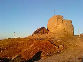 Cabana Omu | |
| Highest point | |
| Elevation | 2,505–2,514 m (8,219–8,248 ft) |
| Prominence | 1,345 m (4,413 ft) |
| Coordinates | 45°26′44.95″N 25°27′22.72″E |
| Naming | |
| Native name | Vârful Omu (Romanian) |
| Geography | |
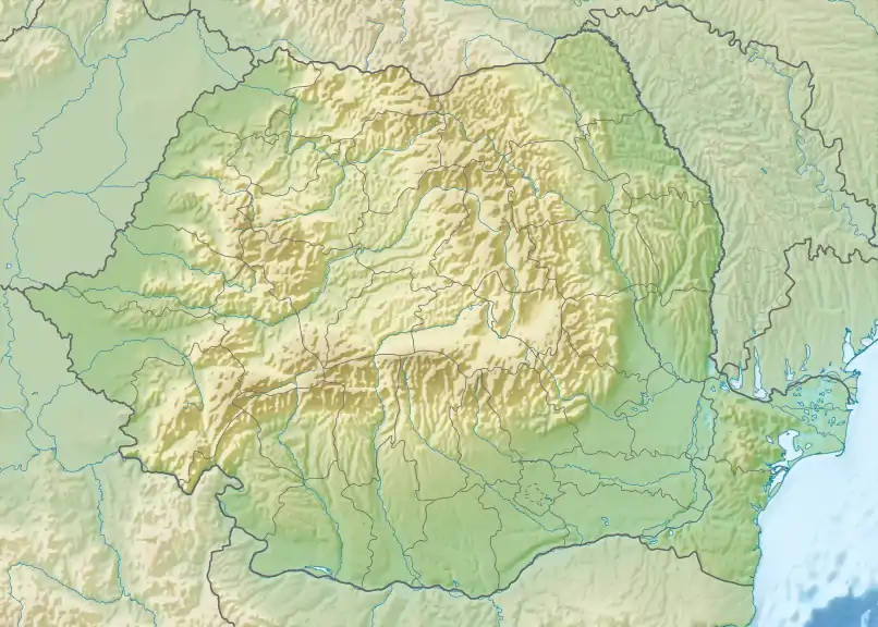 Omu Peak Location in Romania | |
| Location | Romania |
| Parent range | Bucegi Mountains |
The top of Omu Peak is flat and sprawling; there is a weather station and a tourist shelter (Romanian cabana) Omu (2505 m above sea level),[1] which is the highest mountain shelter in the entire Carpathians. The first wooden shelter was built in 1888 on the initiative of the Transylvanian Carpathian Society. Rebuilt many times, it is now as a stone and wooden building, it offers 30 beds and a buffet. The hostel does not have electricity and running water. It is open from March to November.[2]
The top of the mountain is a rock, several meters,[1] which is probably why different sources indicate different heights of the summit at 2505,[3] 2507[4] and 2514 m[5] above sea level.
Climate
Due to altitude, the climate is alpine (Köppen: ETH). The annual average temperature is −1.8 °C (28.8 °F), the hottest month in August is 7.2 °C (45.0 °F), and the coldest month is −10.0 °C (14.0 °F) in February. The annual precipitation is 950.1 millimetres (37.41 in), of which July is the wettest with 140.0 millimetres (5.51 in), while November is the driest with only 49.0 millimetres (1.93 in).
| Climate data for Vârful Omu (elevation 2504m, 1991–2020 normals, extremes 1928–present) | |||||||||||||
|---|---|---|---|---|---|---|---|---|---|---|---|---|---|
| Month | Jan | Feb | Mar | Apr | May | Jun | Jul | Aug | Sep | Oct | Nov | Dec | Year |
| Record high °C (°F) | 5.6 (42.1) |
7.0 (44.6) |
12.2 (54.0) |
12.8 (55.0) |
16.6 (61.9) |
18.1 (64.6) |
22.1 (71.8) |
20.8 (69.4) |
19.2 (66.6) |
16.0 (60.8) |
13.6 (56.5) |
8.2 (46.8) |
22.1 (71.8) |
| Average high °C (°F) | −7.2 (19.0) |
−7.2 (19.0) |
−5.0 (23.0) |
−0.9 (30.4) |
3.6 (38.5) |
7.6 (45.7) |
9.8 (49.6) |
10.3 (50.5) |
6.0 (42.8) |
2.7 (36.9) |
−1.3 (29.7) |
−5.6 (21.9) |
1.1 (34.0) |
| Daily mean °C (°F) | −9.9 (14.2) |
−10.0 (14.0) |
−8.1 (17.4) |
−3.8 (25.2) |
1.0 (33.8) |
4.8 (40.6) |
6.8 (44.2) |
7.2 (45.0) |
3.1 (37.6) |
−0.1 (31.8) |
−4.0 (24.8) |
−8.2 (17.2) |
−1.8 (28.8) |
| Average low °C (°F) | −12.5 (9.5) |
−12.6 (9.3) |
−10.7 (12.7) |
−6.2 (20.8) |
−1.2 (29.8) |
2.5 (36.5) |
4.3 (39.7) |
4.8 (40.6) |
0.9 (33.6) |
−2.6 (27.3) |
−6.5 (20.3) |
−10.7 (12.7) |
−4.2 (24.4) |
| Record low °C (°F) | −32.3 (−26.1) |
−38.0 (−36.4) |
−29.6 (−21.3) |
−25.0 (−13.0) |
−14.0 (6.8) |
−12.0 (10.4) |
−8.0 (17.6) |
−7.0 (19.4) |
−15.0 (5.0) |
−19.0 (−2.2) |
−30.8 (−23.4) |
−32.4 (−26.3) |
−38.0 (−36.4) |
| Average precipitation mm (inches) | 51.2 (2.02) |
50.5 (1.99) |
63.9 (2.52) |
64.6 (2.54) |
98.2 (3.87) |
139.9 (5.51) |
140.0 (5.51) |
105.5 (4.15) |
70.5 (2.78) |
60.3 (2.37) |
49.0 (1.93) |
56.5 (2.22) |
950.1 (37.41) |
| Average precipitation days (≥ 1.0 mm) | 10.2 | 10.8 | 12.5 | 13.3 | 16.2 | 14.9 | 14.3 | 10.7 | 9.1 | 8.4 | 8.7 | 10.2 | 139.3 |
| Average snowy days | 30.5 | 27.6 | 30.9 | 30.0 | 26.6 | 8.4 | 0.3 | 0.2 | 4.1 | 11.4 | 19.6 | 30.0 | 219.6 |
| Source 1: NOAA[6] | |||||||||||||
| Source 2: Administrația Națională de Meteorologie (extremes)[7] | |||||||||||||
References
- "Geografie Muntilor Bucegi" (in Romanian). Cabana Omu. Archived from the original on 2021-01-19. Retrieved 23 March 2021.
- "Cabana Omu" (in Romanian). Cabana Omu. Archived from the original on 2021-01-19. Retrieved 23 March 2021.
- "Introducere in Parcul Natural Bucegi" (PDF) (in Romanian). Archived from the original (PDF) on 4 February 2017. Retrieved 23 March 2021.
- "Bucegi Mountains – Accommodation". Archived from the original on 29 December 2019. Retrieved 23 March 2021.
- "Lista siturilor de importanţă comunitară" (PDF). natura2000.ro (in Romanian). p. 408. Archived from the original (PDF) on 2014-08-20. Retrieved 23 March 2021.
- "Vârful Omu Climate Normals 1991-2020". National Oceanic and Atmospheric Administration. Archived from the original on 2023-08-30. Retrieved August 29, 2023.
- "Vârful Omu: Record mensili dal 1929" (in Italian). Administrația Națională de Meteorologie. Archived from the original on 30 August 2023. Retrieved 30 August 2023.