Ostriv Velykyi Potomkin
Ostriv Velykyi Potomkin (Ukrainian: Острів Великий Потьомкін, lit. 'Big Potemkin Island'; Russian: Остров Большой Потёмкин, romanized: Ostrov Bolshoy Potyomkin), also known as Potemkin Island,[1][2] is a river island located within the Dnipro river in the Kherson urban hromada of Kherson Raion of Kherson oblast of Ukraine.
Native name: Острів Великий Потьомкін | |
|---|---|
 Ostriv Velykyi Potomkin  Ostriv Velykyi Potomkin | |
| Geography | |
| Location | Lower Dnipro river |
| Coordinates | 46°34′40.3″N 32°32′24.4″E |
| Type | River island |
| Area | 25 km2 (9.7 sq mi) |
| Administration | |
| Oblast | Kherson Oblast |
| Raion | Kherson Raion |
| Hromada | Kherson urban hromada |
Geography

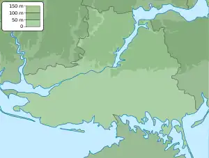
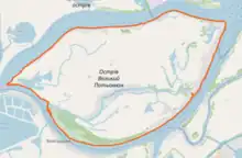
Ostriv Velykyi Potomkin is located within the Dnipro River as a river island. Two small lakes known as Lake Zakitne and Lake Nazarove-Pohorile are contained within the island.[3] The island is divided into two parts by the Strait of Pudov (Ukrainian: Пудова Протока, romanized: Pudova Protoka), which flows through its center.[4] The total land area of the island is approximately 25 square kilometers, located around 5 kilometers to the south of Kherson city and 2 kilometers to the north of the town of Hola Prystan.[5]
History
Being located along the historic route from the Varangians to the Greeks, Ostriv Velykyi Potomkin had strategic significance for the Kyivan Rus', who established settlements on it and used it as their primary Black Sea port. Some historians believe that the historical city of Oleshshia was located on the island, whereas others believe it was closer to modern Oleshky.[6][7] Regardless of which view is correct, archaeological excavations have found evidence of the island's settlement during the period of the Kyivan Rus'.[8]
According to the Institute of Archaeology of the National Academy of Science of Ukraine, in the 14th century, Ostriv Velykyi Potomkin became a trading post of the Republic of Genoa, one of many Genoese colonies along the Black Sea.[5]
After it was conquered by the Russian Empire, following the annexation of the Crimean Khanate in 1783, the island was renamed after Russian prince Grigory Potemkin (Ukrainian: Григорій Потьомкін, romanized: Hryhorii Potomkin), gaining the name it retains until today.[5]
During the Second World War, Ostriv Velykyi Potomkin was used as an outpost by Ukrainian partisan detachments opposing the German occupation of Ukraine, who made use of the lower Dnipro river's floodplains to arrange sabotage operations against the Nazi German invaders.[5]
Russian invasion of Ukraine
Following the 2022 Russian Invasion of Ukraine, Ostriv Velykyi Potomkin came under Russian occupation in the early period of the conflict as a result of the Southern Ukraine campaign. During the 2022 Ukrainian southern counteroffensive in November, it returned to Ukrainian control on 11 November, along with the nearby regional capital of Kherson.[9] However, by 15 December 2022, it was confirmed that Russian forces had re-occupied the island, and had begun forcibly deporting civilians from it.[10][11]
The island has since been a site of fighting between the two sides, attempting to gain control.[12] Yevhen Yerin, head of the Joint Press Center of the Defense Forces in the Tavria direction, stated on 4 January 2023 that Ostriv Velykyi Potomkin remained in a grey zone, despite the presence of military personnel, being controlled by neither side. He added that it was unlikely Ukraine would be able to establish full control over the island before gaining control of east-bank Kherson.[13] On 6 June 2023, as a result of the Nova Kakhovka dam collapse, Ostriv Velykyi Potomkin was partially submerged below the Dnipro river, necessitating the military forces of both sides to withdraw, and thereby temporarily ending fighting on it.[14]
References
- Toponymic information is based on the Geographic Names Database, containing official standard names approved by the United States Board on Geographic Names and maintained by the National Geospatial-Intelligence Agency. More information is available at the Resources link at www.nga.mil. The National Geospatial-Intelligence Agency name, initials, and seal are protected by 10 United States Code § Section 425.
- Hird, Karolina; Stepanenko, Kateryna; Bailey, Riley; Mappes, Grace; Layne, Philipson; Klepanchuk, Yekaterina; Kagan, Frederick W. (9 December 2022). "Russian Offensive Campaign Assessment, December 9". Institute for the Study of War. Retrieved 16 December 2022.
- Shevchenko, I. V. (30 December 2020). "ФАУНА CHIRONOMIDAE (INSECTA, DIPTERA) ПОНИЗЗЯ ДНІПРА. ЧАСТИНА 1: ПІДРОДИНА TANYPODINAE" [CHIRONOMIDAE (INSECTA, DIPTERA) FAUNA OF LOWER DNIPRO. PART 1: SUBFAMILY TANYPODINAE]. Scientific Bulletin of Natural Sciences (Biological Sciences) (in Ukrainian) (29): 73–87. doi:10.32999/ksu2524-0838/2020-29-8 – via Kherson State University.
- "Strait of Pudov". Wikimapia. 2013. Retrieved 20 March 2023.
- Chernysh, Oleh (2023-01-03). "Бої за Великий Потьомкінський острів. Що це означає для звільнення Херсонщини?" [Battles for Potemkin Island. What does this mean for the liberation of Kherson Oblast?]. BBC News Ukrainian (in Ukrainian). Retrieved 2023-03-18.
- Vortman, Dmytro Yakovych; Plakhonin, Andrii Havrylovych (1993). "ОЛЕШШЯ" [OLESHSHIA]. Encyclopedia of History of Ukraine (in Ukrainian). Naukova Dumka. 3: 728. Archived from the original on 19 October 2016.
- Buiskykh, Serhii Borysovych; Iievlev, Mykhailo Mykhailovych (1991). "Про осіле населення понизь Дніпра та Південного Бугу у X—XIII ст" [Settled population of the lower Dnipro and south Buh in the 10th-13th cent.] (PDF). Arkheolohiia (in Ukrainian). 4: 89–104. Retrieved 16 December 2022 – via The All-Ukrainian Рublic Association of Archaeologists .
- "Поселение на Большом Потемкинском острове" [Settlement on Ostriv Velykyi Potomkin]. Мой город — Херсон (in Russian). Retrieved 16 December 2022.
- Rohalska, Nadiia (2022-12-09). "Окупанти готують десантну операцію на Дніпрі: засіли на острові під Херсоном, – Машовець" [The occupiers are preparing an amphibious operation on the Dnieper: they landed on an island near Kherson, - Mashovets]. StopCor (in Ukrainian). Retrieved 2022-12-17.
- "Invaders Plant Landmines at the River Banks in Kherson Region and Attempt to Connect ZNPP to Russian Energy System - General Staff". TSN.ua. 2022-12-15. Retrieved 2022-12-17.
- Rohalska, Nadiia (2022-12-26). "Окупанти намагаються переправитись на правий берег з островів під Херсоном: їх зупиняють ЗСУ" [The occupiers are trying to cross to the right bank from the islands near Kherson: they are stopped by the Armed Forces]. StopCor (in Ukrainian). Retrieved 2022-12-28.
- "Snipers and Icy Water: Ukrainians Risk Dnipro River Crossings". Voice of America. 7 December 2022. Retrieved 2022-12-16.
- "All islands are in so-called 'grey zone' – Defense Forces". Interfax-Ukraine. 4 January 2023. Retrieved 2023-02-03.
- "Дом Остапа Вишни и город-порт Олешня. Какие достопримечательности находятся в зоне подтопления из-за подрыва Каховской ГЭС" [The house of Ostap Vyshnia and the port city of Oleshshia. What sights are in the flood zone due to the destruction of the Kakhovka Hydroelectric Power Plant]. New Voice (magazine) (in Russian). 2023-06-07. Retrieved 2023-06-08.