Otava (river)
The Otava (German: Wottawa) is a river in the Czech Republic, a left tributary of the Vltava River. It flows through the Plzeň and South Bohemian regions. It is formed by the confluence of the Vydra and Křemelná rivers. Together with the Vydra, which is its main source, the Otava is 134.8 km (83.8 mi) long, which makes it the 13th longest river in the country. Without the Vydra, it is 111.7 km (69.4 mi) long.
| Otava | |
|---|---|
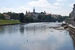 The Otava in Písek | |
| Location | |
| Countries | Czech Republic |
| Regions | |
| Physical characteristics | |
| Source | Vydra |
| • location | Modrava, Bohemian Forest |
| • elevation | 975 m (3,199 ft) |
| Mouth | |
• location | Vltava |
• coordinates | 49°1′30″N 13°29′47″E |
• elevation | 348 m (1,142 ft) |
| Length | 134.8 km (83.8 mi) |
| Basin size | 3,826.9 km2 (1,477.6 sq mi) |
| Discharge | |
| • average | 26.0 m3/s (920 cu ft/s) near estuary |
| Basin features | |
| Progression | Vltava→ Elbe→ North Sea |
Etymology
The origin of the name is unclear. The word otava literally means "second harvest of grass", but the name of the river is probably of pre-Slavic origin and the resemblance to the word otava is only coincidental. A possible but unproven origin is the Germanic word Vatahva, meaning "quick water".[1] According to one theory, the name of the river is derived from the Celtic words áth a ava, which meant "river with many fords".[2]
Characteristic
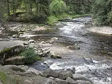
From a water management point of view, the Otava and Vydra are two different rivers with separate numbering of river kilometres. The Otava itself is formed by the confluence of the Vydra and Křemelná in the territory of Hartmanice, and is 111.7 km (69.4 mi) long. In a broader point of view, the Otava (as Vydra) arises in the territory of Modrava in the Bohemian Forest, by the confluence of the Modravský potok, Filipohuťský potok and Roklanský potok at 975 m (3,199 ft) and flows to Zvíkovské Podhradí, where it enters the Vltava River at the elevation of 348 m (1,142 ft). It is 134.8 km (83.8 mi) long. Its drainage basin has an area of 3,826.9 km2 (1,477.6 sq mi).[3]
The Otava has many relatively significant tributaries. The sources and longest tributaries of the Otava are:
| Tributary | Length (km) | River km | Side |
|---|---|---|---|
| Blanice | 94.7 | 32.8 | right |
| Lomnice | 59.3 | 24.9 | left |
| Volyňka | 46.1 | 54.6 | right |
| Ostružná | 41.3 | 88.9 | left |
| Křemelná | 30.3 | 111.7 | left |
| Brložský potok | 27.0 | 35.5 | left |
| Novosedelský potok | 24.3 | 60.5 | right |
| Vydra | 23.1 | 111.7 | – |
| Březový potok | 21.3 | 62.9 | left |
Settlements
The largest settlements on the river are the towns of Písek and Strakonice. The river flows through the municipal territories of Hartmanice, Rejštejn, Dlouhá Ves, Sušice, Dobršín, Rabí, Žichovice, Velké Hydčice, Malý Bor, Horažďovice, Střelské Hoštice, Horní Poříčí, Katovice, Strakonice, Slaník, Přešťovice, Štěkeň, Čejetice, Putim, Kestřany, Písek, Čížová, Vrcovice, Vojníkov, Vráž, Ostrovec, Oslov, Varvažov and Zvíkovské Podhradí.
Bodies of water
The drainage basin is rich in fishponds, especially in the area of the České Budějovice Basin. There are 4,768 bodies of water in the basin area; the largest of them is the Labuť pond with an area of 101 ha (250 acres), built on the stream of Kostratecký potok. In the area of the confluence of the Vltava and the Otava, the extensive Orlík Reservoir is built on the Vltava, which also extends into the lower course of the Otava. Apart from this reservoir, no other reservoir or pond is built directly on the river.[3]
History
In earlier times, the banks of the Otava were popular for gold panning. It is still possible to find flakes of gold here.[2] The sand panned for gold also gave the name to Písek (literally "sand").[4]
Tourism
The Otava is suitable for river tourism. The course of the river is lined with many campsites for tourists and paddlers.[2]
References
- Loucká, Pavla (1997-09-05). "Řeky si pojmenovali nejdřív" (in Czech). Vesmír. Retrieved 2023-10-12.
- "Otava – skvělá řeka, kde vodácká doprava není příliš hustá" (in Czech). CzechTourism. Retrieved 2023-10-12.
- "Základní charakteristiky toku Otava a jeho povodí" (in Czech). T. G. Masaryk Water Research Institute. Retrieved 2023-10-12.
- "Historie města" (in Czech). Město Písek. Retrieved 2023-10-12.
External links
- River flow at Písek station – Flood Warning and Forecasting Service of the Czech Hydrometeorological Institute