Outline of Meghalaya
The following outline is provided as an overview of and topical guide to Meghalaya:

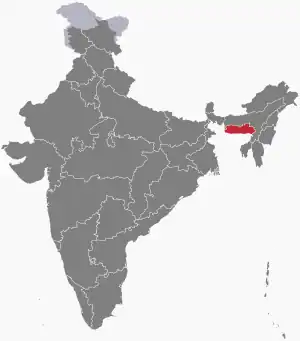
Location of Meghalaya
Meghalaya – state in north-east India. The name means "the abode of clouds" in Sanskrit. The state is the wettest region of India, recording an average of 12,000 mm (470 in) of rains a year.[6] About 70% of the state is forested.[8] The Meghalaya subtropical forests ecoregion encompasses the state; its mountain forests are distinct from the lowland tropical forests to the north and south. The forests are notable for their biodiversity of mammals, birds, and plants.
General reference
Names
- Common English name: Meghalaya
- Official English name(s): Meghalaya
- Nickname(s):
- Adjectival(s): Meghalayan
- Demonym(s): Meghalayans
Rankings (amongst India's states)
- by population: 23rd
- by area (2011 census): 23rd
- by crime rate (2015): 22nd
- by gross domestic product (GDP) (2014): 24th
- by Human Development Index (HDI):
- by life expectancy at birth:
- by literacy rate:
Geography of Meghalaya
- Meghalaya is: an Indian state, and one of the Seven Sister States
- Population of Meghalaya: 3,211,000 (2014)
- Area of Meghalaya: 22,429 km2 (8,660 sq mi)
- Atlas of Meghalaya
Location of Meghalaya
- Meghalaya is situated within the following regions:
- Time zone: Indian Standard Time (UTC+05:30)
Districts of Meghalaya
Municipalities of Meghalaya
- Cities of Meghalaya
- Capital of Meghalaya: Capital of Meghalaya
Demography of Meghalaya
Government and politics of Meghalaya
- Form of government: Indian state government (parliamentary system of representative democracy)
- Capital of Meghalaya: Capital of Meghalaya
- Elections in Meghalaya
Union government in Meghalaya
Branches of the government of Meghalaya
Executive branch of the government of Meghalaya
Legislative branch of the government of Meghalaya
Judicial branch of the government of Meghalaya
- High Court of Meghalaya
- Chief Justice of Meghalaya
Law and order in Meghalaya
- Law enforcement in Meghalaya
History of Meghalaya
Culture of Meghalaya
- Architecture of Meghalaya
- Cuisine of Meghalaya
- Monuments in Meghalaya
- World Heritage Sites in Meghalaya
Art in Meghalaya
Sports in Meghalaya
Sports in Meghalaya
- Cricket in Meghalaya
- Football in Meghalaya
Symbols of Meghalaya
- State animal:
- State bird:
- State flower:
- State seal: Seal of Meghalaya
- State tree:
Economy and infrastructure of Meghalaya
Health in Meghalaya
Health in Meghalaya
See also
References
- "Definition of Meghalaya in English from the Oxford Dictionary". Oxford Dictionaries. Archived from the original on August 19, 2012. Retrieved 30 August 2016.
- Define Meghalaya at Dictionary.com
External links
- Official website
- Tourism of Meghalaya (Official)
- Outline of Meghalaya at Curlie
This article is issued from Wikipedia. The text is licensed under Creative Commons - Attribution - Sharealike. Additional terms may apply for the media files.
