Pagar Alam
Pagar Alam (sometimes written as Pagaralam, Jawi: ڤاݢر عالم), is a city in South Sumatra, Indonesia. It was formerly part of Lahat Regency, from which it was separated as an independent city on 21 June 2001; before being established as an independent city, Pagar Alam was an administrative city within Lahat Regency. It has an area of 633.66 km²[2] and a population of 126,181 at the 2010 Census[3] and 143,844 at the 2020 Census;[4] the official estimate as at mid 2022 was 147,071 (comprising 75,280 males and 71,891 females).[1]
Pagar Alam | |
|---|---|
| Other transcription(s) | |
| • Jawi | ڤاݢر عالم |
 Coat of arms | |
| Nickname: "Besemah" | |
| Motto(s): Besemah Kota Perjuangan (Besemah, The City of Struggle) | |
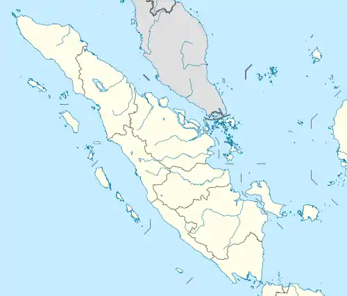
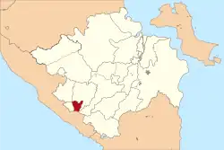 Location within South Sumatra | |
| Coordinates: 4°1′0″S 103°15′0″E | |
| Country | |
| Province | |
| Government | |
| • Mayor | Ida Fitriati |
| • Vice Mayor | Novirzah Djazuli |
| Area | |
| • Total | 633.66 km2 (244.66 sq mi) |
| Population (mid 2022 estimate) | |
| • Total | 147,071 |
| • Density | 230/km2 (600/sq mi) |
| [1] | |
| Time zone | UTC+7 (Indonesia Western Time) |
| Area code | (+62) 730 |
| Website | pagaralamkota.go.id |

Pagar Alam is located by the Bukit Barisan Mountains, at the feet of Mount Dempo, a volcano and the highest mountain in South Sumatra. It is 298 km southwest from the province's capital city of Palembang and 60 km southwest of the town of Lahat. The city is bounded by Bengkulu Province to the south, Jarai District to the north, Kota Agung District to the east and Tanjung Sakti Pumi District to the west. Pagar Alam is the one of the main suppliers of vegetables in Palembang. Its location in the highland makes the city slightly cooler than many of the other South Sumatra cities; this, together with its astounding landscape, makes the city one of the main tourist destinations in South Sumatra and it is often visited by local tourists, especially from Palembang. Currently, the city is led by Alpian Maskoni as the mayor of the city.
Geography
Pagar Alam is located by the Bukit Barisan Mountains, at the feet of Mount Dempo. Much of the soil in the city consists of latosol and andisol with rugged and hilly topography. The soil in this city is classified as soil with high fertility (class I).
Demography
In 2000, Pagar Alam's population was only 112,025 and it increased to 126,181 ten years later, and 143,844 after a further decade. One of the factors in the population increase has been the settlement of migrants who want to live in this city. Beside the city's native inhabitants, the Malay (Besemah), the city population also consists of several other groups, such as the Javanese, Minang, Batak, Chinese, Arabs, and Indians.
Administrative Districts
Pagar Alam is administratively divided into five districts (kecamatan), tabulated below with their areas and their populations at the 2010[3] and 2020[4] Censuses, together with the official estimates as at mid 2022.[1] The table also includes the number of administrative villages (rural desa and urban kelurahan) in each district, and its postal codes.
| Name of District (kecamatan) | Area in km2 | Pop'n Census 2010 | Pop'n Census 2020 | Pop'n Estimate mid 2022 | Density per km2 (2022) | No. of villages | Post codes |
|---|---|---|---|---|---|---|---|
| Dempo Selatan (South Dempo) | 239.08 | 11,611 | 12,783 | 12,981 | 54.3 | 5 | 31521 |
| Dempo Tengah (Central Dempo) | 151.96 | 12,663 | 14,749 | 15,142 | 99.6 | 5 | 31520 |
| Dempo Utara (North Dempo) | 123.98 | 19,934 | 23,031 | 23,608 | 190.4 | 7 | 31510 |
| Pagar Alam Selatan (Southern Pagar Alam) | 63.17 | 44,755 | 50,361 | 51,361 | 813.1 | 8 | 31522 - 31529 |
| Pagar Alam Utara (Northern Pagar Alam) | 55.47 | 37,218 | 42,920 | 43,979 | 792.8 | 10 | 31511 - 31519 (a) |
| Totals | 633.66 | 126,181 | 143,844 | 147,071 | 232.1 | 35 |
Note: (a) excluding the kelurahan of Sukorejo, which has a post code of 31551.
Climate
Pagar Alam has an elevation moderated tropical rainforest climate (Af) with heavy rainfall year-round.
| Climate data for Pagar Alam | |||||||||||||
|---|---|---|---|---|---|---|---|---|---|---|---|---|---|
| Month | Jan | Feb | Mar | Apr | May | Jun | Jul | Aug | Sep | Oct | Nov | Dec | Year |
| Average high °C (°F) | 27.3 (81.1) |
27.8 (82.0) |
28.1 (82.6) |
28.3 (82.9) |
28.3 (82.9) |
28.0 (82.4) |
27.8 (82.0) |
27.9 (82.2) |
27.9 (82.2) |
28.0 (82.4) |
27.6 (81.7) |
27.3 (81.1) |
27.9 (82.1) |
| Daily mean °C (°F) | 22.6 (72.7) |
22.9 (73.2) |
23.2 (73.8) |
23.4 (74.1) |
23.4 (74.1) |
23.0 (73.4) |
22.6 (72.7) |
22.8 (73.0) |
22.9 (73.2) |
23.1 (73.6) |
22.9 (73.2) |
22.7 (72.9) |
23.0 (73.3) |
| Average low °C (°F) | 18.0 (64.4) |
18.1 (64.6) |
18.3 (64.9) |
18.6 (65.5) |
18.6 (65.5) |
18.0 (64.4) |
17.5 (63.5) |
17.7 (63.9) |
17.9 (64.2) |
18.2 (64.8) |
18.3 (64.9) |
18.0 (64.4) |
18.1 (64.6) |
| Average precipitation mm (inches) | 321 (12.6) |
257 (10.1) |
284 (11.2) |
284 (11.2) |
229 (9.0) |
142 (5.6) |
126 (5.0) |
151 (5.9) |
177 (7.0) |
255 (10.0) |
286 (11.3) |
313 (12.3) |
2,825 (111.2) |
| Source: Climate-Data.org[5] | |||||||||||||
Transportation
Atung Bungsu Airport
Atung Bungsu Airport is the only airport in Pagar Alam. It is opened on 28 February 2013.[6] With air transport it now is less than one hour from Palembang, instead of eight hours using land transportation.[7]
Education
Colleges
- Sekolah Tinggi Ilmu Tarbiyah (STIT)
- Sekolah Tinggi Keguruan & Ilmu Pendidikan (STKIP) Muhammadiyah Pagar Alam
- Sekolah Tinggi Ilmu Ekonomi (STIE) Lembah Dempo Pagar Alam]
- Sekolah Tinggi Teknologi Pagaralam (STTP) Simpang Mbacang
Tourism
Beside its landscapes, the city also offer heritage tourism with a lot of megalithic sites. The Pagaralam government will build an integrated tourism area in a 26 hectare bamboo forest at Curup Jahe in North Pagaralam.[8]
References
- Badan Pusat Statistik, Jakarta, 2023, Kota Pagar Alam Dalam Angka 2023 (Katalog-BPS 1102001.1672)
- LETAK GEOGRAFI DAN TOPOGRAFI DAERAH
- Biro Pusat Statistik, Jakarta, 2011.
- Badan Pusat Statistik, Jakarta, 2021.
- "Climate: Pagar Alam". Climate-Data.org. Retrieved November 11, 2020.
- "Lapangan terbang Atung Bungsu Pagaralam diresmikan". February 28, 2013.
- Irene Sarwindaningrum (June 15, 2015). "Kota Pagar Alam: Atung Bungsu Pembuka Pintu..."
- "Media Indonesia - Pagaralam Bangun Kawasan Wisata Terpadu". Archived from the original on 2011-07-18. Retrieved 2011-07-12.
External links
- (in Indonesian) Official website
Regencies and cities of South Sumatra | ||
|---|---|---|
Capital: Palembang | ||
| Regencies | ||
| Cities | ||